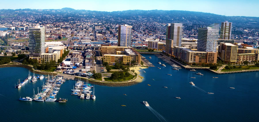
While the ground was broken for Signature’s massive Brooklyn Basin project (a 64-acre East Bay development which will yield up to 3,100 units of housing, 200,000 square feet of commercial/retail space and 30 acres of open space along Oakland’s waterfront) back in 2014, the focus has been on preparing the site and infrastructure for construction.
But in two weeks time, Oakland’s Planning Commission is slated to approve the plans for Brooklyn Basin’s first building to rise, an eight-story structure with 241 apartments over 3,000 square feet of ground-floor retail space, 10,000 square feet of amenity and lounge space for residents, and a ground floor garage for 241 cars on Brooklyn Basin’s “Parcel B.”
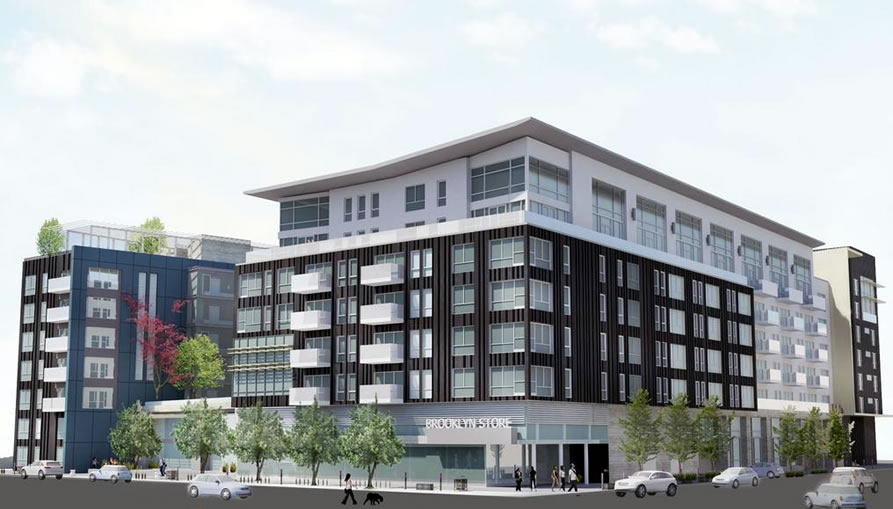
Designed by BAR Architects, the Parcel B building will front 9th Avenue, at the corner of Clinton Lane, across the street from the future Shoreline Park.
Glad to see a development going in that will add more cars to the already-packed freeway that borders it.
Make sure to bike there when you check the project out
Or not. When I tried to bike through the area at the end of June, the stretch of the Embarcadero between JLS and 5th Avenue was closed. Not insurmountable, but having Google Maps was helpful.
It’s closed for replacement of the bridge over the Lake Merritt inlet…for a year or two I believe. We can be hopeful, I guess, that something of interest happens during that interval.
the project’s parking ratio is over 1.3!
Agreed, the master plan should be redesigned. It looks like a generic “master plan”. Why to the blocks always have to by so large and so car oriented. They could have designed a border garage and then a walk-able interior. Instead we get a business park full of residences? Who wants to live in that!
This will be awesome. Love the waterfront treatment with multiple mooring sites and that small beach. I’d love to see this urban waterfront development occur across other Bay front parts of Oakland. It has the potential to become something spectacular. If Coliseum City gets built it will only add to it all. Bay front symphony hall a la Sydney? One can dream.
That’s what I’m talking about
Interesting how you support highrise development in Oakland, but oppose pretty much everything proposed for SF.
I’ve noticed this too. Do you have a financial incentive to do this, Dave?
High-rise development can be good or bad. I don’t totally oppose it, but I do oppose it in SF as my belief is SF should be a low to mid-rise city. To enhance the terrain – the hills.
As to development in general, SF is max’d out given the current infrastructure. Most new housing and office development should, IMO, shift to the East Bay. Better access to transit and more central to the area’s population which is shifting east.
This development will provide a big net increase in East Bay housing and that is a win-win-win. For Oakland, for SF and for the Bay Area as a whole.
Because the transportation capacity in Oakland is not seriously impacted already?
Come on man. At least PRETEND to show some consistency.
In your opinion…..but not in the opinion of people who prefer to live in San Francisco. Which is a lot of people.
So high rises enhance Oakland’s terrain, because there aren’t any hills in Oakland?
Nothing like a beach on an industrial waterway!
Nothing like a waterfront with no beach at all… SF Embarcadero
SF has miles of beaches. Nothing like a city with miles of waterfront and no beach at all …. Oakland.
Snark attack.
The Embarcadero’s an incredible asset to the city. And far more economically productive (both retail and commercial/light industrial) than would be a beach in that location.
I also think it looks great and is exactly what Oakland should be doing.
(I’m a fan of waterfront development in Oakland AND in San Francisco)
The dream for a waterfront A’s stadium is still alive.
See A’s owner taking a look at waterfront site for new ballpark
Which is the same waterfront site Mayor Quan was pushing back in 2013, at which point A’s co-owner Lew Wolff characterized the redevelopment of the Howard Terminal site as…”as close to impossible as anything.”
Somebody’s already trying hard to promote the Howard Terminal site for the A’s. When you search on “Howard Terminal, Market Street, Oakland, CA” in Google Maps, the sidebar image is of an A’s game at the Coliseum. Funny.
Exactly. The A’s have been talking about a new stadium in Oakland for years (decades?). I doubt they’re serious. My guess is that they’re hoping to move to San Jose or sell.
Since that time, the City has initiated and is close to completing its Downtown Specific Plan, which is the vehicle for pre-approving a potential A’s stadium at the Howard Terminal…..not a perfect plan but the City seems to be doing its part.
I think Oakland is trying. I don’t think the A’s are.
… actually the As would prefer to move to San Jose but MLB won’t allow that.
Yep. The A’s are going to pretend to look for a stadium until they get permission to move to San Jose or Vegas or somewhere else, or until they sell the team.
The M&R report (now pay walled) intimated that “it’s different this time” because majority owner John Fisher is involved. We’ll see…
Depending on whether you are talking about Oakland or San Francisco, it’s like two different people completely.
Ha Ha… you look at that cluster of prison like buildings, and that pile of rocks, and see beaches & symphony hall??
[Editor’s Note: If you look at the plans for Crane Cove Park, as linked above, you might see beaches and an events “hall” as well. And don’t forget about the plans for The Ramp.]
Great looking project, scale, variety of heights and architecture. Beautiful location. Glad to see Oakland stepping up to the plate with more housing.
Are they removing the 9th Ave terminal building? Don’t see it in the drawings.
Never mind, found some other renderings that show how it will be incorporated.
Looks like it’s just akin to keeping the facade for show. Too bad they couldn’t rehab it like the piers on Embarcadero.
I wouldn’t say “just the facade”…it looks like 5-6 bays (tho only the roof on the last two bays). The Terminal has the disadvantage of being rather remote from things, unlike the Embarcadero in SF…and of course the world only needs just so much space to launch self-driving trucks into the bay 🙂
That open space “shoreline park” will be completely wasted space. Really unfortunate.
It would be nicer if they replicated what was done in Point Richmond at Craneway Pavilion.
I am so excited about this project! Compared to what used to be there (or not be there you could say), this is just amazing. Even Dave and Furturist are pretty positive about it all!
I wonder if the extra density could support a BART infill station around there, maybe around 14th and 8th or so?? LM station isnt that far…..but….
Just for the record, I am mostly, always upbeat and positive about new developments in SF or other cities. I support new housing, responsible growth, improved transit systems, respect for neighborhood context and scale, and even(oh my!) support high rise construction in areas appropriate and zoned for it.
A BART station at 8th and 7th would be pretty amazing, but will never happen.
There’s been talk of a San Antonio/Eastlake infill station at 14th St for awhile (info on page 9-10, 23 of this slide deck). It makes sense; that area is one of the densest in Oakland, the tracks are at level grade at ground level, so building a station would cost far less than a new underground station, it’s right next to the 16th St overpass that connects the waterfront to the rest of Oakland, and that stretch between Lake Merritt & Fruitvale is the longest in Oakland without a BART stop (2.8 miles). Hopefully the influx of people at Brooklyn Basin is the push that finally makes it happen.
Hopefully the plan would be for a station that could be skipped. BART really needs to address the lack of express trains. Same comment for an in-fill station at 30th and Mission
This, exactly. I’m all for lots of BART infill stations … but BART service is slow as it is. We need some express bypass tracks in several places (does every train need to stop at West Oakland? Glen Park? Colma?). We could also benefit from some inner-system shuttles – e.g. from 16th & Mission to MacArthur, or Berkeley. Take some of the SRO pressure off the core lines at rush hour.
Ideally, we could get a second transbay tube including a BART station here and in Alameda.
BART could branch off just north of a San Antonio station, with additional stations at 5th/Embarcadero (Brooklyn Basin station) and JLS, turn west with a station on Alameda island and then in a new tube to points west in SF. Just sayin’.
“But in two weeks time, Oakland’s Planning Commission is slated to approve the plans for Brooklyn Basin’s first building to rise…”
So the initial approval that got the infrastructure improvements started in 2014 didn’t include approval of the buildings themselves? I suppose that makes sense if the project as a whole included entitlements for the rough massing and scale of the expected buildings. It would be a bummer if the developer submitted their proposal and were rejected because the project was too large.
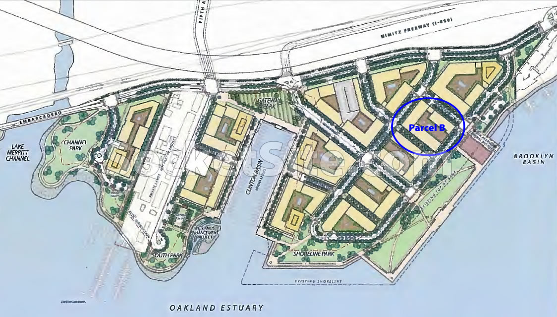
That’s correct and in fact this proposal is only for Building B. Each build will require separate approvals and I believe it is probable there will be different architects involved with future buildings, although an exterior design language has been specified to ensure a level of external consistency. Also, I believe the build for Shoreline Park was approved sometime this past Winter.
The basic parameters were all set in the original EIR, like the MacArthur BART project. This building has been through a few rounds of Design Review and is requesting a Final Development Permit to begin construction. The EIR, upcoming community meetings, and timeline are at namelink.
This will be the third time the Building B proposal has gone to the Planning Commission this summer. The previous attempts (June 22 and July 27) resulted in requests for revisions. I hope the author’s optimism is well placed and the third time is the charm so this work can get going.
2 or 3 rounds of planning comments is very typical for nearly every project. it’s up to the development team to keep the ball rolling.
I’ve got to admit this project looks pretty awesome. I just wonder how much consideration was given to those rising sea levels…
Pfft, that’s a problem for future us 😛
Based on environmental impact reports filed by the developer, Brooklyn Basin is a problematic project. As are more than two-dozen megaprojects now rising around San Francisco Bay.
Read the exhaustive coverage by the San Francisco Public Press from last year and navigate to the interactive map (which already needs updating).
We found that all told, projects with development cost of more than $21 billion have been permitted on lands lower than 8 feet in elevation. Scientists studying sea level rise say the high-level predictions for the West Coast for the year 2100, including extreme storm surge, put flood levels that high. See also: Treasure Island, Mission Rock, Golden State Warriors arena, Pier 70, Candlestick Point, Facebook headquarters and many more.
Local and regional land-use enforcement is generally anemic, and building standards are wildly inconsistent from city to city. Municipalities have a financial incentive to approve such projects because they yield short-term tax windfalls. But future taxpayers will likely have to fund expensive protections such as levees, seawalls and emergency relocations for flood-damaged communities caused by the current waterfront building frenzy.
This concern is the correct perspective on the matter. Sea level rise WILL continue and nature cannot be bargained with. A Netherlands or Venice-style system of massive tidal locks / flow controls at the GG channel seems highly unlikely due to depth of channel and volume of shipping traffic. Without a tidal gate placed there, the problem can only be dealt with on-location, that is, everywhere around the Bay at or under 10 feet elevation.
If sea levels rise so far to affect those projects then $21B will be a drop in the bucket compared to other damages.
Better to fight global warming than to passively accept it. And part of fighting global warming is to create more efficient communities that reduce fossil fuel consumption. Like this one.
Hmm, I wonder if global warming and sea level rise is the “hook” that could finally allow for a stronger regional government – an entity to coordinate and control planning and transportation on a Bay-region level; it’s primary impetus would be to account for and accommodate sea level rise and other global warming impacts, but in the process it could become the one regional agency responsible for transportation and infrastructure planning and integration.
TL; DR: We need a “Greater SF” government, much like London or Toronto, in order to be as efficient and productive as possible.
I am not as familiar with the East Bay as I should be since I usually go north on weekends.
For anyone familiar with the Oakland and San Leandro Bay front, could this type of project be replicated for stretches between here and through San Leandro? I assume its mostly industrial right now but, as that use fades in the Bay Area, this type of project would be a perfect replacement use of the land.
Imagine a min-Miami style waterfront stretching down a chunk of the East Bay shoreline.
In some spots it already is (what? the elderly retiree aspect of Miami isn’t what you meant? 🙂 )
But the opportunities are limited: if you go north from SL, you have the airport, then Bay Farm Island (which is already built up w/ SFR’s…and I don’t think Alameda is itching to become Palm Beach West), then the MLKJr Shoreline Park, then the remaining stretch of small parcels on a narrow shoreline.
Ok, I’m imagining a mini-Miami style waterfront down a chunk of the East Bay shoreline, and now I need a stiff drink.
Seriously, there is a lot of underused land between this project and Coliseum; the problem would be any sense of connection to the rest of the city across some formidable barriers: lots of trains, a truly revolting freeway, and lots of industrial/warehouse/distribution facilities that are in no way fading – vacancy rates are low and demand is high, actually. (Those Amazon drones are going to have to assemble their deliveries somewhere, and there might even be a few decent working -class human jobs involved.)
Oakland can easily (except for the NIMBY’s) shovel plenty more housing in just by building up empty lots within a few blocks of a BART station and along existing residential-commercial corridors. Land that’s this intensively industrial now might be more suited to expansion and modernization within that use. And, it’s not necessarily the wisest thing to concentrate development of any kind hard up against an uncertain future shoreline. We could be better off trying to restore some wetlands instead.
The project is exciting but the master plan and skyline are boring. City of Oakland should take this opportunity to create a unique shoreline and waterfront community to boost the image of the city. Planning and design is the first important key to success.
Surprisingly (to me) Brooklyn is a historic name for this place, and not just an attempt to make a trendy connection to Brooklyn NY.
Hmmm….a floating water bridge to Alameda seems interesting to try out maybe, and the classic: Caution advisory signs : Its wet and slippery!
Unfortunately a floating bridge would block marine traffic.
Why such low density? This is an odd use of precious land. Why not take a sustainable approach and build densely? The consistent under building of land in the Bay Area is short sided and pandering to the “progressive” no change agenda.
Why such a high density? This is an odious use of precious landfill. Why not take a sustainable approach and reclaim the wetlands? The extensive building of land in the Bay is shortsighted and passes on very high and unfunded costs to maintain to future generations.
What are you talking about? The plan is for 3000 units in 64 acres, of which half will be open space. That’s averaging 100 du/ac over the entire developed portion of the site. That isn’t bad at all.
UPDATE: In related news, Plans for Brooklyn Basin’s Future Shoreline Park Refined.