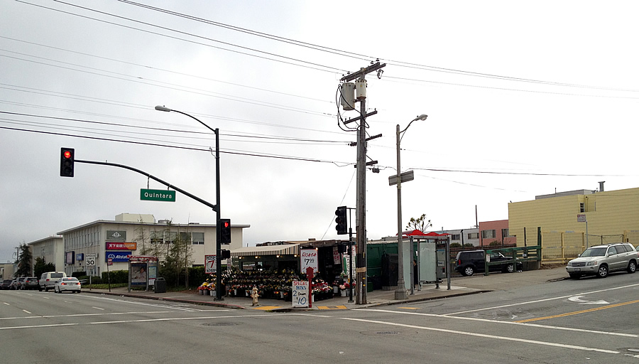
The plans to level the Sunset District flower stand and two undeveloped lots on the southwest corner of Quintara and 19th Avenue, and construct a four-story building across the site, have taken one step forward and two steps back as the City isn’t in favor of the preliminary proposal nor design.
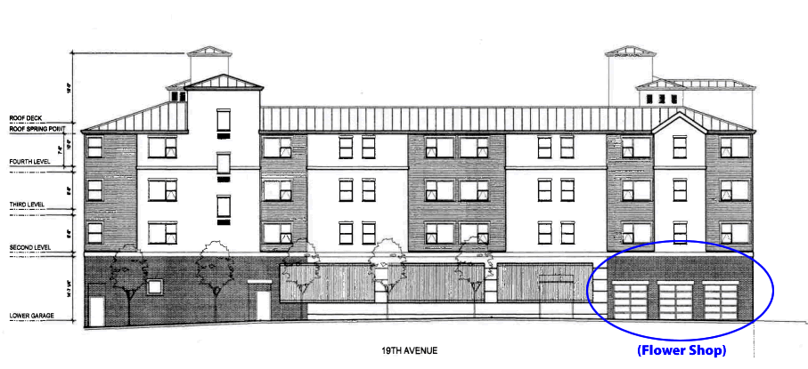
As we first reported last year, the proposed development includes 42 apartments over parking for 56 cars at the base of the building, with a 615-square-foot commercial space on the corner designed for the flower stand to return.
From Planning’s review of the preliminary project plan which was mailed on Friday:
“Parking is not an appropriate street-facing use. The Department requests that the project respect the legislated nine-foot setback along 19th Avenue and provide residential units with individual entrances in accordance with the draft ground floor residential design guidelines.
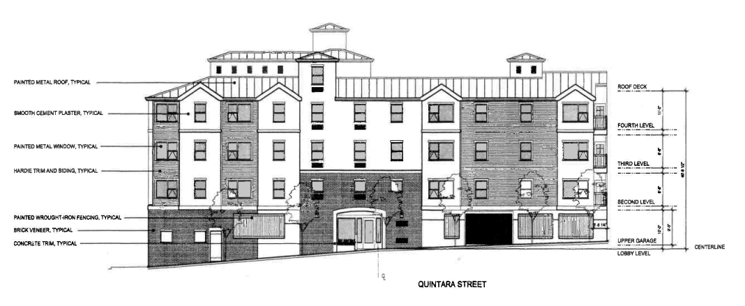
A similar treatment is requested along Quintara Street where the lobby should also be located.”
But, the proposed flower shop was deemed “appropriate at the corner.”
In addition, while the site is zoned for development up to 40-feet in height, it isn’t principally zoned for more than two-unit buildings. And while the development team was angling to invoke the State’s Housing Density Bonus Program to allow for more units and height, “The City finds that the State Density Bonus Law cannot be applied to a Planned Unit Development (PUD) as requested in the Proposed Project, since a PUD is itself a discretionary increase in density granted by the Planning Commission above what is allowed as-of-right under current zoning.”
The state law could, however, be applied to an alternative code-compliant scheme which consists of four two-unit buildings and two single-family homes with a total of 10 dwelling units across three-fifths of the project site (the parcels fronting Quintara and 55 feet along 19th). And if applied, the 35% density bonus would allow for up to 14 units to be built on the scaled-down site.
Or if the project team moves forward with its pursuit of a Planned Unit Development, as originally proposed, a maximum of 41 units rising up to 40 feet in height would be allowed across the full site.
Is that a “faux-prison” style? or a mix hybrid rail-station-library-stucco-stone-clad miserable design sim. to the stuff we see in the sunset where planning did not pay attention to the monstrosity of elements until too late? Looks like there wont be any green-space, green-roof, solar, or understanding of how the sea-water will deteriorate everything till its too late…
Transit? what transit? (North to South) that is… You cannot board the bus system currently.
It’s hard to say anything definite about the design, given the included sketch, but it looks no worse than the squat two story concrete thing in the background of the photo.
That is the problem. The squat, oppressive Sunset. Among the most unattractive neighborhoods of any US city. And this is a middle class neighborhood not a lower/poorer class neighborhood.
The mistake that was made when the Sunset was planned, in greed IMO, maximize as many units as possible to make someone a profit, is being replicated today. A shame.
Just imagine what could be done if the Sunset was being developed today?! But oh wait – with the current PTB it would turn out the same. We are scr****.
Class project – take a Sunset block at the ocean. Start from scratch. How would you develop it? It could be done in an intimate, open space, resident friendly way and still up the density significantly. We will never see that. 100 years from now – who knows?
The mistake that was made when the Sunset was planned was 125-foot-deep lots with setbacks. The area could have supported 50% more population with no visual impact if it had been platted a little tighter.
What does transit have to do with this design?
The lack of any green space – here or anywhere in these new developments – is criminal.
There is only one solution at this point. Altering the planning code to require ground level open space (restrict the project footprint) across the board. Planning refuses to do it so an initiative seems the only way. I brought this up at our local neighborhood group recently and the response was good.
its the details that need to be worked out.
Allow residential projects a larger footprint and commercial less so.
That one change to the code would transform, in a good way, what the City is trying to do here and maybe more impactful what they are trying to do with the Hub,
This is a fairly prominent intersection in the city and could support a much larger, more dramatic building than this exceedingly modest and forgettable proposal.
19th is a transit diasater. Adding a significant amount of density to this site is absurd.
Sloat has turned into a commute nightmare and Portola too. The City cannot keep adding large amounts of units without any transit mitigation. There is none here.
This is ripe for an initiative challenge if they try to go higher density.
The overbuilding downtown is impacting all of the City. 19th is bad enough, but Sloat and Portola are bottlenecks in the past few years during morning commute.
Provide a transit improvement in the area before allowing a developer to squeeze in every unit the developer can get to maximize profit. JMHO.
In the meanwhile, people could just walk 3 blocks to the light rail on Taraval.
Nah, too easy.
But in fairness, a huge part of the rush hour traffic on 19th is people commuting to the peninsula, many of them coming from Marin. No local transit improvement could alleviate that.
Ugly prison look isn’t required? I thought that was by design. Recall a recent architectural study re: Sunset District found only 30 some residences with any historic value whatsoever. Thousands built since WWII are just plain ugly and horrible.
“Parking is not an appropriate street-facing use” and “provide residential units with individual entrances” seem like rules that would not be appropriate for 19th Ave. There is little pedestrian traffic on 19th to care what the street-facing appearance of the building is. Nobody wants their door to open out to 19th Ave. Seems a bit ridiculous. A little green space buffer, however, would be nice.
19th is a mess, but as pointed out earlier it’s mostly the Marin-Peninsula traffic. It sucks for the Sunset to be a thoroughfare between two places that don’t contribute anything to the neighborhood but fumes. I’m not sure improving 19th (whether by some elevated or underground road) would do anything but encourage people to think that it’s reasonable to live in Marin and work in the Peninsula which is just a recipe for sprawl and idiotic commutes.
Whoa, ~90% of 19th Ave traffic is San Franciscans, including the commute traffic. Only ~3k Marin residents commute to the Peninsula and some of those carpool. 19th Ave carries ~75k cars per day each direction, per Caltran traffic count.
FWIW, the removal of two elevated freeways in SF (Embarcadero and Central north of Market) shifted about as much traffic to 19th Ave as the entire Marin-Peninsula commuter flow, according to Caltran studies.
@Jake, you and your facts are roaching the SF buzz which knows, just knows, that SFers are green, car-free, all-organic, socially-conscious altruists. It is only other people who drive through our streets in their devil machines, polluting and ruining our idyllic neighborhoods like the leeches they are, and eating fast food and drinking cheap beer and wine too.
I’m curious as to where you get the 90% figure? I drive 19th fairly regularly and my anecdotal experience is that the percentage would be much lower. Now, I would probably also argue that a large portion of the traffic is passing through SF but is not necessarily commuters.
I used the census and caltrans stats as mentioned above. Caltrans does traffic counts of Rt 1 and Quintara is actually one of the intersections where they count (and Lincoln, Fulton, Lake, …). Don’t know how you or anyone else could reliably know what percentage of the cars you experience originated in Marin. Also, don’t know how your anecdotal experience could possibly be much of a representative sample, given that Caltrans says 27 million cars per year pass by Quintara on Rt 1 southbound.
As you indicate, I don’t know how I or anyone else could know what percentage of the cars originate in Marin or SF for that matter. With 100k plus cars entering SF daily on route 1 at the SM county line and 50k plus entering SF daily at the 101 junction, it would seem that the percentage of SF residents driving on 19th Ave would be less than 90%.
As to your first sentence, what I wrote was wrt to the cars you encounter in your personal experience. The US Census gathers the origin and destination for commuters. They tell us that more than twice as many SF residents commute to Marin for work as Marin residents that commute to San Mateo and Santa Clara combined. They tell us that tens of thousands of residents of the western neighborhoods of SF commute to San Mateo and Santa Clara counties. If you wanted you could look up how many residents of your census tract commute to San Mateo. The Census data indicates the commute flow is in the range of 90% SF residents on 19th Ave.
As to your second sentence, well, Rt 1 in SF from the junction with 101 to the SM county line is 7 miles long. It isn’t some closed tube the whole length. The many cross streets admit entries and exits, allowing trips on 19th Ave that originate and terminate in SF without ever registering on the counts you mentioned. It also allows an SF resident to enter SF at either end and exit 19th Ave to a cozy parking space in SF. I’ve done this myself, perhaps you have too.
And BTW, the Rt 1 and 101 junction in SF is not at the county line. It is in the Presidio and the traffic count there includes cars that enter Rt 1 from Doyle Drive. Shocking as it might seem, there are residents of SF that drive through the Presidio via Doyle Drive and Rt 1. IIRC, quite a few complained when Doyle was closed and their traffic rerouted during the rebuild.
Jake,
As you note, the regular commute flow may very well be approximately 90% SF residents and I don’t dispute this. However whenever I travel southbound on Route 1 in the AM, there appear to be plenty of northbound automobiles entering SF, not all of which exit before it becomes 19th Ave. They could, in fact, be SF residents returning to their homes, but are more likely to be a portion of the 75k SM residents commuting into SF.
In addition, 19th Ave serves as the primary western highway for transiting SF for all other purposes in addition to commuting. As anyone who has driven 19th Ave during non-commute hours can attest, the flow of traffic is not necessarily light and given the information available I think it’s tough to ascertain the residency of passengers and/or drivers of the vehicles. As far as I know, the census does not delineate trips that are non-commute oriented.
When I drive from around South Park to around SF State or Stern Grove, I use 280 to Brotherhood Way to Junipero Serra to 19th Ave. Maybe a “portion” of the ceaseless northbound flow you encounter on 19th Ave in the AM is me. As for the 75k SM residents commuting into SF, well, you could lookup their destinations by census tract if you want. I think you would find there aren’t many job centers in the western half of SF, especially in proportion to the jobs in the eastern half of SF that take the 280 and 101 traffic from SM in the AM.
Yes, the US Census commute questions are just for commute to work. SFMTA publishes estimates of all trips taken in SF by residents and non-residents and by travel mode. According to them, ~90% of trips in SF are by SF residents. And the car mode share of SF residents is about the same as non-residents. Sadly, the sandy western sublurbs of SF are congested by the neighbors driving their cars on average ~3 trips per day per person. Those folks backing up the (non-existent) 19th Ave turn lane onto Sloat aren’t Daly Citizens on their way to the Lucky/FedEx/Petco/Ross/etc strip mall. They got those and Ohno Hawaii BBQ around Serramonte, not far from the Target and Home Depot where so many SFers shop.
BTW, in the area of SF parked on either side of Stern Grove (Taraval to Eucalyptus and west of 19th Ave), one third of the residents with a job commute to work in a county other than SF (mostly mostly SM). 90% of those commuters drive to work. That means that on average about every other parksidian house contributes a commute car to our neighboring counties. And it means that just that wee little slice of the western SF suburbs generates more than half as many car commuters to SM county as all of Marin. We may finally have found an answer for why it costs so much to live in such poor weather: they need the fwy to the golden eggs.
I wonder which takes more time for a Parksidian: to walk to wait for and ride the Taraval hypertoad express to a job within walking distance of Market St or drive solo to free parking at Oracle in Belmont or thereabouts.
Thanks, Jake, that is great data. Disabuses me of my preconceptions. Though it does support what studies have shown: build a freeway (or rail line or whatever) and development will follow. People will make their decisions based on the facts out there. And those who live in the Western neighborhoods have found the 280 to SM County seems to be acceptable, while having to slog thru SF and various bridges make the East Bay and Marin less an option except for the most sturdy of commuters.
If the roads were improved so that the commute was acceptable, more people would make that choice. So is 19th Ave a “success” in preventing sprawl the way the 280 has managed to encourage it? Who knew?
many people in richmond and presidio and laurel heights (anywhere west of masonic lets say) uses 19th to get down to peninsula. me included. I wish 19th were elevated.
19th is a problem without a solution at this late date. IMO.
No way an elevated roadway would be built and no way an undergrounding will be done.
The best solution,though just as impractical, would be to tear out the housing from the Park to Taraval and do a greenway akin to Sunset. Adding a few lanes to boot.
UPDATE: Rezoning Could Quadruple Density of 19th Avenue Development