As we first reported earlier this year:
Plans for a modern 10-unit development to effectively rise on the northwest corner of 17th and Roosevelt, below the summit of San Francisco’s Mount Olympus on the southern border of Ashbury Heights, have been in the works since 2014.
As proposed by Dawson & Clinton, the existing single-family home at 271 Upper Terrace, which sits atop the site and was purchased, along with the undeveloped lot at 4500 17th Street below, for $2.2 million in 2014, would be demolished while the existing duplex at 301-303 Upper Terrace, which was purchased for $1.85 million, would be remodeled; the three lots would be subdivided into five; and four new duplexes, three of which would front 17th Street, would rise up to six stories in height upon the project site, for a total of ten (10) modern units with parking for a total fifteen (15) cars.
And with San Francisco’s Planning Department having just issued the proposed development a Preliminary Mitigated Negative Declaration, which, if upheld, would obviate the need for a detailed environmental impact report to be prepared, the Mt. Olympus project is one step closer to reality.
While an appeal of the aforementioned Preliminary Mitigated Negative Declaration was subsequently filed in May, said appeal was withdrawn last week and the Mitigated Negative Declaration for the project was quickly signed and issued.
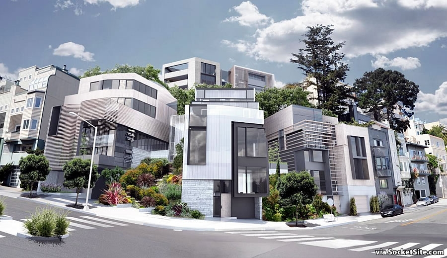
And if the refined plans for the proposed Mount Olympus development, as newly rendered above, are approved and the ground is broken, the project team is now estimating it would take around 37 months to complete, including the required excavation of the existing hillside and removal of about 13,640 cubic yards of soil.


Either that is a terrible rendering or it’s showing something that is unappprovable: a garage that exits directly into a crosswalk. I assume it’s the former.
I thought exactly the same thing. Must be the rendering. It really makes it look like that unit is centered almost directly on the intersection. Better to exit onto Roosevelt than the middle of the intersection, but hopefully not into a crosswalk!
It’s kind of funny because the corner property only one block up 17th (at Clayton) was developed in the past 10 years or so, and has a similar condition with a garage entrance VERY close to the intersection, and I always wondered how it was approved, and what a huge frustration it would be try to use the garage entrance. To me, it was an OBVIOUS case of where there should have been one curb cut to a common parking garage rather than individual garage doors in a townhouse style development.
OMG I made the same comment 11 years ago (see link above).
Nice garden and new cross walk on 17th St. I wish there is a traffic light at the intersection. Driving up the steep slope of 17th, it is painful top stop behind a line of cars at the stop sign.
Especially when you drive, as I do, a manual shift car or motorcycle.
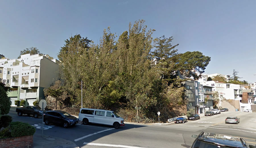
That corner appears to me to be made of sheer rock. Excavating it will be interesting.
That does look like a lot of work – is that how much work was done to make surrounding lots buildable?
4 years to entitle and 36 months to construct, not to mention likely another year to get a building permit. 8 years for 10 units.
So we are talking 1,000 to 1,400 truckloads of dirt? That is really going to make traffic suck on this busy and steep street.
“13,640 cubic yards of soil”?
That would be a cube 24 yards – 72 feet ! – across. That seems absurd, even for a hillside that clearly will require a lot or digging…I wonder if 13,640 cubic FEET wasn’t meant (or maybe 1364 cubic yards)
If you know the area, which is an intersection countless San Francisco drivers traverse past regularly daily, you wouldn’t doubt that it’s 24 yards. But if not, look at the picture. It’s easily 72 feet across.
But 72 feet high as well ?? And 72 feet deep ?? Or more to the point: is the plan to remove the entire hill ?? It certainly sounds like it, and – combined with a (more than) 3 year timeline – it certainly sounds, if not downright wasteful, then at least the most extravagant idea anyone could come up with.
I think they mean 13,640 cubic yards of soil. If you go out to the site, stand there and look at, it looks a cube 72*72*72…
Well then I’m glad this group wasn’t around during the city’s founding: I’m sure Nob Hill would have ended up Nob Flat.
It should be open space.
WOW. Really? I used to drive past this lot on the way to my house. The trees are covering the HUGE amount of large boulders/stones there. Good luck with that.
UPDATE: Mount Olympus on the Market