While running a few years behind schedule, the three alternatives and two design options for redesigning the 2.2‐mile segment of Market Street between Octavia Boulevard and The Embarcadero, with the stated goal of revitalizing and improving San Francisco’s busiest pedestrian street, bicycle thoroughfare and transit corridor, “making it safer and easier for people to get around and creating a vibrant and inclusive destination where people want to live, work and visit,” have been consolidated into a master Better Market Street plan.
From San Francisco’s Planning Department, which has just commenced the formal environmental review required to proceed:
In general, the proposed project would continue to provide four travel lanes on Market Street, with two center lanes and two curb lanes between Franklin and Beale streets. More than four lanes west of Franklin Street and three lanes east of Beale Street would be provided. The width of the vehicular travel lanes would remain approximately the same as existing conditions.
New sidewalk-level bicycle lanes would be installed in each direction on Market Street between the curbside lanes and sidewalks, and a new street-level parking protected bicycle lane would be installed on Valencia Street between Market and McCoppin streets.
And if all goes as now envisioned, the Environmental Impact Report (EIR) for the City’s Better Market Street project, which kicked-off in 2011, should be released around the end of this year, the project could be approved in mid-2019, and the ground for the first segment of the project, from Sixth to Eighth, could be broken in 2020.
We’ll keep you posted and plugged-in.
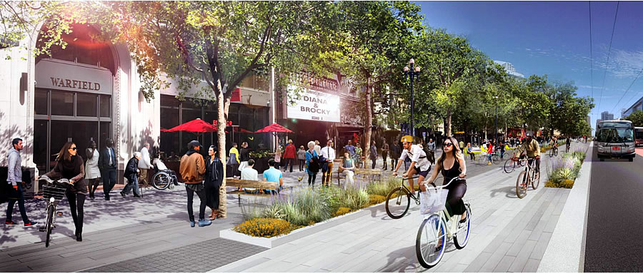
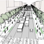
I love the first picture: Let’s clean up Market Street by putting trees in front of the strip joint so people can’t see it.
Better bike lanes are a solid improvement, but two factors will prevent this tree-lined sidewalk cafe dream vision: (1) the weather, and (2) the Tenderloin.
You’re also forgetting (3) the bike lanes are the same level as the sidewalks, so every tourist / phone-distracted hipster / sprawling homeless person will be weaving in and out of and blocking the bike lanes. As a bike commuter, I’m stunned that this passed multiple levels of review.
Uh, biking on Market street *today* you have to weave around tourists and homeless folks. But the new lanes will also supposedly be lined with a planted/physical barrier (along with textured/bumpy paving, like they do in Europe) dividing them from the sidewalk.
Ah yes, a few bumps in the pavement will keep all tourists and other pedestrians from straying into the bike paths. Just like how on the bike path in the Panhandle, I *never* have problems interacting with oblivious pedestrians. (That last bit was sarcasm, BTW…)
And in any event – and as someone who bikes Market from Davis to McAllister every evening – the only thing I’m dodging on the street at present are Muni busses, Ubers, and scooters. If you’re having to weave around homeless people and tourists while biking, it sounds like you’re biking (illegally) on the sidewalk.
Um, no—I biked around a homeless person wandering into the intersection at 7th and market last night. And I agree, the Panhandle bike path could use a planted barrier / textured paving different from the other sidewalks in the Panhandle, though aligning a *new* bikeway along the parking edge of Fell and Oak would be ideal. Just like this one on Market.
Well I agree 110% about the Panhandle path – we should follow the mode of Copenhagen and other cities, and have dedicated “bike freeways” – and the Panhandle path is the perfect place to start, given that there’s a perfectly usable (and recently repaved) pedestrian path paralleling it to the south.
This rehaul is already going to be very costly, meanwhile the city continues to let much of its existing infrastructure deteriorate. Cost was likely a factor in the bike lane design. Also, I am not sure how you keep pedestrians out of a bike lane without building an unsightly solid wall or a high fence. I am sure aesthetic considerations were part of the design decision.
Life is always a little inconvenient, and we have to learn to make do. Automobile drivers and even other pedestrians have to deal with distracted pedestrians and sprawling homeless people, too. Such is life in the big city. Just keep your eyes open and navigate around the obstacles in your way–this is good advice for all areas of life.
I don’t think it would be a negative at all to have ~3′ high open-work fencing between the sidewalk at the bike lane … something attractive and very open, so that it’s not a visual barrier, but that’s still substantial enough to prevent meandering and accidental wandering into the bike lane. And it would serve double-duty by deterring jaywalking and mid-block Uber/Lyft pickups.
It’s still a vast improvement over existing conditions.
If they repave and correct the horrific street pavement quality. That should come FIRST.
Yes, ideally they should have planned for curbs marking the bike lanes with the surface lowered to the street level. That works very effectively in European cities. I suppose they could slather the bike lanes in bright green like elsewhere that would be a pretty clear indication for stray pedestrians.
Heroin addicts and other “victims of society” probably don’t even see the green?
Any link to the source of this announcement? The Better Market Street site has not been updated with any final info. The “Headlines” section ends in 2017, the “Press Releases” section ends in 2015, and the image carousel links to meetings from 2 months ago.
It hasn’t been formally announced (other than as reported above).
^ this is a solid point. Easy solution would be to drop the bike lane to drive lane elevation to create a grade separation and an indication to pedestrians to stay out.
I suspect that if they did that that the bike line would turn into a river whenever it rained.
See the little planting sections. One guess, and one only, what those will be used for.
If they can keep the fecal matter to the tree planters it would be an improvement over the current status quo, where it is randomly deposited anywhere on the sidewalk.
Anyone who has visited Barcelona recently and walked Diagonal will see a lot of similarity to the design, reduction in lanes and installed of permanent bicycle pathways.
La Rambla was also prominently featured in design proposals at the Civic Center Public Realm meeting last week.
Fitting to take examples from another gridded city retrofitting pedestrian-friendliness onto its automobile-oriented design. If only we actually shared their willingness to build seas of 6-story residential.
It’s true. Barcelona is always the example I like pointing to when people complain about 6 stories being too tall for non-commercial areas.
And nobody would dare criticize the Eixample as a sea of victim of “six-story sameness” when Gaudí made the format work just fine…
I have never been one to complain about the “sameness” in Mission bay, personally.
please tell me you are not comparing Mission Bay to the Eixample. mission bay is a wasted canvas.
Will buses share the road with private cars? From my experience, one of the reasons for slow transit speeds is because it has to share the road with automobiles. If the buses had their own dedicated lanes (and grade-separated and barricaded to prevent cars and trucks from entering the lanes), that would increase average speed and reduce trip times.
The current operation of bus-only lanes on Mission and Geary is a case-in-point. The ‘bus only’ paint fails to prevent all non-municipal drivers from entering the lane. In some cases, the design requires drivers to enter the lane – for example when making a turn. Muni would substantially benefit from physically separated bus lanes.
Joel,
Completely agree with the inefficiency of buses sharing lanes with cars. A grade separated lane would be great. Even better would be NO cars on Market between Embarcadero and 5th, 6th, or 7th. I’m not anti-car at all but the truth is we don’t need private cars on Market St.
The plan (from my recollection) includes banning all private vehicles, including Lyft and Uber, from Market street. The only vehicles allowed will be buses, streetcars, medallioned taxis, and delivery vehicles.
That’s correct. Though how the city plans to prevent cars from turning there is dubious, since they can’t seem to enforce traffic laws generally.
I have seen some videos on YouTube of remotely-actuated, retracting bollards. The bus transponder triggers the system and the bollard retracts into a cavity until it is flush with the street and allows the bus to pass. Once the bus has passed, the bollard rises from the street and again blocks the lane.
These videos are often accompanied by other videos showing motorists, following behind the bus, who whether from ignorance of the bollards or selfish attempts to beat the bollards, soon collide with or find themselves “beached” on a rising bollard. It is hard not to laugh at their misfortune.
The bollards seem like a clever, but I suspect expensive, solution to keep private cars off of a lane.
Bollards can be viewed in person on the shuttles serving the central campus at Stanford.
At least Market represents a centralized corridor to enforce rather than being spread out all over the city. It wouldn’t take many tickets costing hundreds of dollars (and probably a publicity campaign too) to deter people.
Put a fork in small business along that corridor; as if it wasn’t already dead. Bus and bicycle only is great for transit and safety, but bad for business as these commuters whiz by. Let’s just build homeless shelters along that strip. Every one of SF’s progressive policies win!
You have it backwards, getting people out of cars increases foot traffic for adjacent businesses on a corridor.
You’re not getting people off speeding bicycles and buses as they commute. Pedestrians will not increase with a bus only/ bike only model. With the exception of Zuni, everything died on that corridor after it was made unfriendly to cars.
Such as? I don’t know that too many folks are pining for the donut shop that used to be at 7th and Market.
I admit I’d love if that poke place on the ground floor of the Twitter building would stay open past 8.
This is not Hayward. Do people in SF really expect to pull up right up to the junky Chinese electronics shop in their 5,000 pound Escalades?
Looks like they left the trains and tracks of the F out of these fantasy renders.
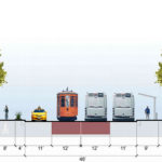
Looks like the F survived in the street section. Hopefully that means light rail is going to remain.
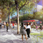
The tracks are visible in the 2nd rendering at the top of the page. They aren’t being removed.
Street car tracks are certainly being kept. There are plans to add additional tracks near 7th (IIRC) for short turns (which might not be in this particular plan).
The plan does include a short-turn loop for F-line streetcars, using McAllister and Charles Brenham Place (the northern extension of Seventh Street). This will allow Muni to balance service on the F-line, a much needed improvement.
Looks so clean and beautiful, like a proper boulevard in a fine European city! Looking forward to relaxing with an outdoor coffee near the warfield theater.
Heh heh
Glad this is finally happening, but lets not forget that the first public meetings on this project were in 2011. Seven years for a 2.2 mile bike path. Pathetic leadership.
“…a new street-level parking protected bicycle lane would be installed on Valencia Street between Market and McCoppin streets”
That’s less than the length of a football field. Seems a bit strange to have a super short spur like that. Certainly better than nothing, but why not extend the parking protected lane way farther down Valencia?
By all means, lets build more bike lanes for cyclists to ignore and ride on the sidewalk anyway. [cue the “It’s all pedestrians/cars faults we pay no attention to traffic laws” diatribe]
Does this project include the redesign and rebuild of UN and Hallidie Plazas? Or is that on the wishlist and out of scope? Seems like they would both be great candidates for a design competition à la Harvey Milk Plaza / Castro Station.
UN plaza redesign is in the scope of the Civic Center Public Realm plan.
Hallidie Plaza redesign is in the scope of the Powell Station Modernization project.
Great social engineering to bring in more young and mobile, but a inconvenience for others. Where do delivery trucks load, essential for the livelihood of businesses? Where’s the drop off for the disable and families with kids and baggage in tow?
Design is too bicycle centric.
This is all addressed in the plan. But by all means, fly off the handle about literally nothing.
You clearly haven’t read the plan, since it includes a lot more loading/dropoff and pedestrian safety improvements than Market currently has.
Check out the cross section. 64 feet dedicated to sidewalks/transit stops, 46 feet dedicated to transit/auto, and 16 feet dedicated to bicycles.
I wish the folks who did these rendering were held accountable for a reality check. Will the bike path really be tiled in that sexy basalt like tile? No, it will very likely be the bright green paint on asphalt. Why can’t the folks at planning show reality?
Putting the bike lane, higher than the street is a good idea. Currently being the same level as the street, uber and lyft use it as parking, and it creates many unsafe situations as bicycles swirve onto traffic without looking.
I don’t think it’ll be asphalt if it’s at sidewalk level. Probably not tile, as you said. I’d guess concrete like a normal sidewalk.
Can we get a clarification on when construction is supposed to start? The above article says 2020, but the Better Market Street website says:
* 2018 – Answer to FAQ question 6, construction schedule
* 2020 – The graphic on the front page
* 2021 – Answer to FAQ question 4, project schedule
2020. As reported above.
Looks like the elevated bike path will come from part of paved sidewalk and car loading zone. But there are also fire hydrant and BART entrances along the way. Looks like a very expensive project to pull off.
I assume that the reason it’s not a more radical change is that we can’t afford to move the streetcar rails.
how to fix market street. clean it up. dont allow people to poop and shoot up on the sidewalks. force addicts into treatment and hospitalize mentally ill. Voila. All revitalized. without doing that, the rest is lipstick on a pig.
Gotta agree. There should be 2 teams of cleaners EVERY day. One team starting from City Hall, one team starting from the Ferry building. They can meet up at Powell Street. Driving some kinda golf cart Zamboni power washing machines. Heck make them look like little cable cars. Have one team play Tony Bennett music, one team play Scott McKenzie music to make tourists and pedestrians wake up and get out of the way. Get Shriners hats. Whatever.
But updating the sidewalk and not doing the hard work of addressing the filth and social issues? That is a plan for failure.
or how about arresting the drug dealers and rounding up the vagrants. then we wouldn’t need to power wash the place twice a day.
The drug dealers outside of the Civic Center Bart stop are crazy threatening. They need to be put in jail asap.
The mentally ill? Not jail – They need to be institutionalized for their own good. Napa?
The Vagrants? If we can afford to jail them – we can afford to throw some more shelters up on the piers for them to have basic housing…
Quite the tripping hazards currently out there along market street, question is should there be an EQUITY balance and some of this funding be spent on other major corridors that have not seen ANY focus and funding from the city….?
the primary tripping hazards on market street are people sleeping on the sidewalk.
Is this really anything more than losing a significant part of the sidewalks to bike lanes?
We’re gonna miss those sidewalks. And there’s going to be an awful lot of weaving side to side for everybody wherever there’s a bus/tram stop. Not to mention the pedestrian/bike congestion at intersections.
But, hey, at least this way bicyclists will know we really appreciate them.
Um, WHAT? There are currently 2 lanes of traffic each way. There will continue to be 2 lanes of traffic each way. Currently bikes are squeezed into the traffic lanes at every intersection (and hence cars and the peloton are dangerously interweaving). Under the new plan, they’ll be separated the whole way – so all the brash Muni drivers no longer have to honk their horn in anger when they’re “stuck” behind a bike (that inevitably winds up going down Market at twice the average speed as a Muni bus).
Regardless, there are sidewalks of 25′ and 20′ on the N and S sides of Market, respectively. If you can’t accomplish whatever it is you try to accomplish on a sidewalk in 20′ or 25′, then no amount of planning and bike-bashing is going to help you.
Market Street is too narrow to accommodate four traffic lanes, two bikes lanes, wide commercial sidewalks, a “sidewalk energizing zone” (or whatever they call outdoor seating), AND the islands required by the inner set of public transit lanes.
We’re trying to squeeze too much in. Something should have been moved to Mission St., either the bikes or most of the buses.
As for me “bashing” bikes, my preference would have been for a bike lane down the middle of Market, with no vehicular left turns allowed for the entire stretch. From what I understand, that wasn’t an option because of the cost of moving the rails apart. My second choice would be to turn over Mission St to bicycles and, if needed, ONE lane of buses going one way towards the Ferry Building.
Where are all of the drug dealers in the rendering?
Sorry, but the artist didn’t put in filthy raving homeless people and junkies shooting up on the sidewalks. Local color, as they say.