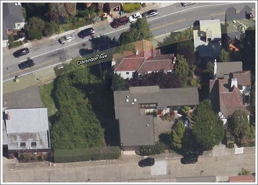
First approved for infill development in 2005 despite its neighbors’ objections, including one referring to the proposed project as “a source of oppression,” the construction of 1410 Stanyan commenced at the end of 2010 and is nearing completion.
While the site is clearly visible in the pre-construction aerial view above, as a plugged-in reader writes, like the neighbors, you probably didn’t see this one coming:
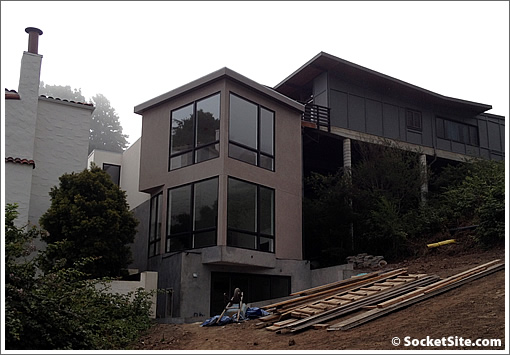
The new two-story home was “pushed, squeezed [and] shoehorned into the space between two existing homes,” one fronting on Clarendon and the other on Mt. Spring Avenue. With respect to any oppression, at least they didn’t build a three-story home as proposed.
The big green space in the aerial which you probably thought was the site? That’s actually an undeveloped, and currently unbuildable, stretch of Stanyan Street, the Stanyan Street Right of Way.
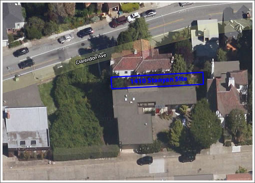
Maybe you could use a bright red box to highlight the area on the aerial map.
[Editor’s Note: We didn’t want to give it away in the first aerial, but a second has been added above.]
It looks like there is still a ton of greenspace/yard even with this source of oppression (to wealthy neighbors) in place.
What are they building, a hallway? That tract doesn’t even have road access.
Totally did not see that coming.
Is that a garage visible on the ground floor, perhaps to be accessed via the hillside where the material currently lies?
Anyone know what this lot transacted for?
This is a great solution and clean modern home to a difficult infill site.
[Removed by Editor along with referenced, and appropriately challenged, comment.]
One of my first jobs as a young Architect to be was as the number two to guy doing residential design in San Francisco.
Back in those pre-digital days, he would spend entire afternoons at city Hall patiently going through what were called “Sanborn” maps of the city real estate parcels looking for build-able lots no one knew about.
That section of Stanyan has always been very mysterious to me. The paved portion of Stanyan t-bones into Belgrave (the last section being super-steep), but the maps show it continuing up the hill, even crossing Clarendon. Between Clarendon and Belgrave, its a sort-of-private, gated mini-park; it looked more like a big vacent lot up past Clarendon. Is this all city land that they declined to pave because of the steepness, or is it privately held?
There used to be a street nearby called ‘Estelle’ running off Stanyan, between Belgrave and 17th (shows up on old Sanborn maps). It was carved into lots by the city long ago but you can still see the odd-shaped pieces on the map. This is a non-standard part of town…
At least one of the neighbors saw this one coming as the lot was sold off by the uphill house owner on Mt. Spring.
No garage but lower area now living space. Access to property unknown.
@redseca2: just the other day I was looking up Sanborn maps, available on line (link below) if you have a SFPL account (free). It takes a bit of sleuthing around to look up the correct city area but it’s fascinating to see how things evolved over time in SF
The Google maps non-45-degree view shows it after construction is underway. It looks like it gets access to Clarendon by eating up nearly half of the unbuildable area for a driveway. I’m sure they’ll replant, but still. Perhaps that area is technically the extension of Stanyan. Otherwise, the address makes little sense. Anybody know?
Yeah, I ride my bike past there all the time. I thought for sure they were just building a driveway for one of the upper houses.
Personally, I’d rather have that new/recent construction a few doors down Clarendon with the four-story glass elevator, but this is nice, too. 🙂
[Editor’s Note: Gone (And Going) Up At 47 Clarendon.]
Looks like the property sold with entitlements on 9/7/2010 for $450,000 (Deed K223-6). The prior sale was for the same price in 1994. Not a bad deal, actually, if you don’t need parking. See link below for property information.
http://ec2-50-17-237-182.compute-1.amazonaws.com/PIM/
Here is a map that shows Stanyan crossing Clarendon, Mountain Spring and St. Germain, and extending up to “Twentieth Street” which appears to correspond with Palo Alto Street.
http://www.sfgenealogy.com/sf/sanborn/v6indb.pdf
Thanks for that old map Patrick. Gotta love the optimism of continuing the SF grid right through Miraloma Park and up the east face of Mt. Davidson and the south face of Twin Peaks. There would be solid work for a half dozen more clutch and brake shops if the streets had been built out that way.
Listed at 2,498,000. No parking(?)