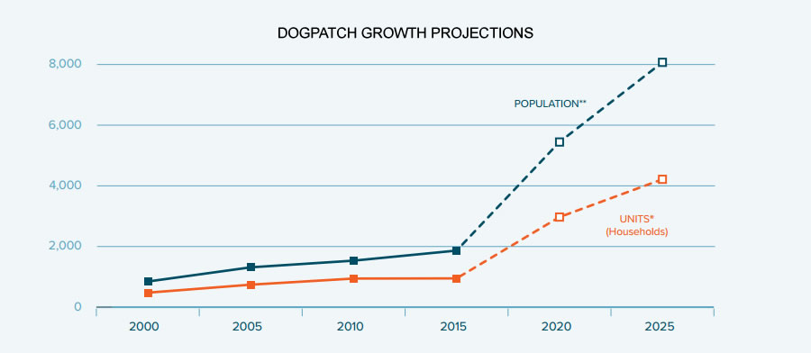
With around 3,000 units of housing expected to be built in Dogpatch over the next decade, not including another 2,700 units which could eventually rise on the Potrero Power Plant site, the population of the neighborhood is expected to soon double, if not triple.
And with that in mind, a comprehensive Central Waterfront / Dogpatch Public Realm Plan – which is intended to both guide and prioritize the development of new neighborhood public spaces, streetscapes and parks – has been in the works since 2014, the final draft of which is slated to be presented to San Francisco’ Planning Commission in two weeks time.
Three core tenets form the foundation of the plan:
1. A network of complete streets: “Dogpatch Streets should be complete in all senses of the word: broken links in the street grid should be closed, and areas with new residential and commercial growth should include the amenities serving higher pedestrian and bicycle use. Pedestrian and cyclist connections to adjacent neighborhoods, new waterfront parks, and neighborhood institutions should be comfortable and safe.”
2. A diversity of high-quality open spaces: “As the neighborhood continues to grow with new residents and workers, informal open spaces should be upgraded, expanded, and multiplied alongside existing formal parks. Renovations should accommodate diversifying user needs, upgrades to facilities and furnishings, and night time safety. New open spaces should be implemented throughout the plan area, giving more equal and ready access to recreational facilities.” And,
3. A landscape expressive of unique history and character: “Streetscape and open space designs should be responsive to immediate land uses, and endeavor to highlight remnant warehouse architecture and other historic fabric. Rather than draw on standard solutions found ubiquitously throughout the city, designs, materials and furnishings in the public realm should also borrow from industrial forms and palette. Key historic buildings associated with past institutional use should also be adaptively reused to serve new needs.”
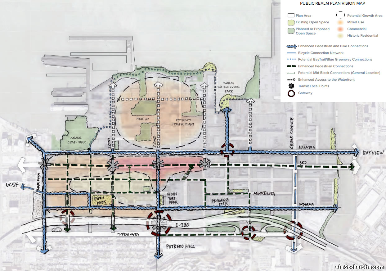
As mapped below, enhanced pedestrian connections are envisioned to be concentrated in the northern portions of the plan area, where residential and commercial land uses are most prevalent.
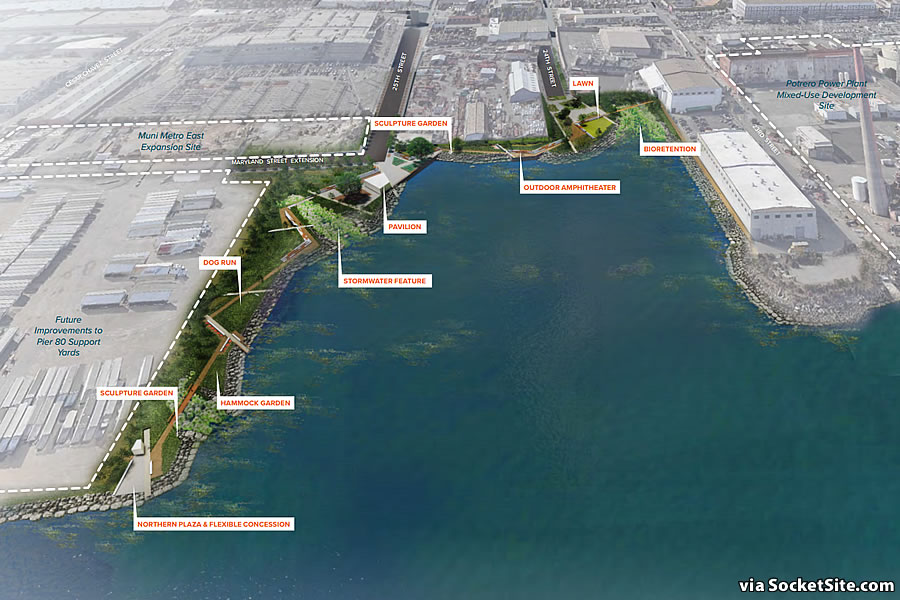
And the largest open spaces are to be arrayed along the bay’s shoreline, making east-west streets – especially those providing connections to the adjacent Potrero Hill neighborhood – even more important, with 18th, 20th and 25th Streets becoming connectors to large waterfront open spaces, such as the future Warm Water Cove Park as newly rendered below.


The development pipeline for Central Waterfront (including the Potrero Power Plant) shows roughly 6400 residential units. Attention should also be given to the amount of office space being developed in Dogpatch, Potrero/Showplace and in nearby Mission Bay. Commercial development will bring tens of thousands of workers and visitors to the area.
Back in the day this would certainly mean the leveling of Irish Hill at 22nd. I wonder how they’ll do it now.
I believe what remains of Irish Hill is set to be the centerpiece of a park or undeveloped open space.
It’s a shame the Spreckels Sugar Factory didn’t survive into this era of preservation and adaptive reuse. It would have made for an impressive neighborhood landmark and a prime candidate for chic industrial lofts or open floorplate offices the market is so hungry for.
Yes but: “The 1899 brick power house, machine shop, meter house and purifying shop built by SF Gas & Electric still stand on (sic) Humbolt Street”
Aren’t these the same buildlngs – tangentially related to the refinery, and largely proposed for demolition – that were the subject of much discussion here?
I fear we would have been told it “didn’t pencil” and left w/ a token chimney, or bronze sugar-sack off to the side.
Hopefully the C&H Sugar factory in Crockett doesn’t meet the same fate. Seems like that operation might be reaching obsolescence.
They could easily add 10K unites in this space if creating more housing were at all a priority. Unfortunately, Potrero Hill NIMBYs are the worst kind of NIBMYs.
Weird for you to talk about things that quite literally haven’t happened yet in regards to this site.
Meanwhile, trying to build a 3 story structure anywhere on the west side will get you crucified.
What’s with the 3 “Transit Focus Points”? I would love to collapse the 2 Muni stops into a single stop at 22nd & 3rd for the following reasons:
* Much closer to Caltrain Station
* More business/commericial destinations at 22nd than 20th + 23rd combined. 23rd station is at a corner of food truck parking lot, ambulance parking lot and moving truck parking lot. Whoever planned that station is probably called Bart Simpson.
There are actually four Transit Focus Points on that map, but one of them is 22nd & 3rd.
My bad, there are actually five. I didn’t see the one on 22nd under 280.
I agree. The siting of the T-line boarding platforms up and down 3rd Street (Willie Brown Blvd) could use rethinking.
The platforms are extremely expensive, since they are long enough to accommodate a 4-car train even though the line uses only a single car, and are way the hell up in the air, due to running in and out of the subway.
Platform cost is one of the best arguments for low-floor boarding streetcars like the Bombardier Cobra.
The platforms on Embarcadero are long enough for 4-car trains, but once you turn onto 3rd, it’s all 2-car platforms starting with stop on 4th between King & Berry.
A network of complete streets? So the SFMTA are going to open Minnesota through the Woods yard? 🙂
UPDATE: Plan to Shape the Public Realm of Dogpatch Slated for Adoption