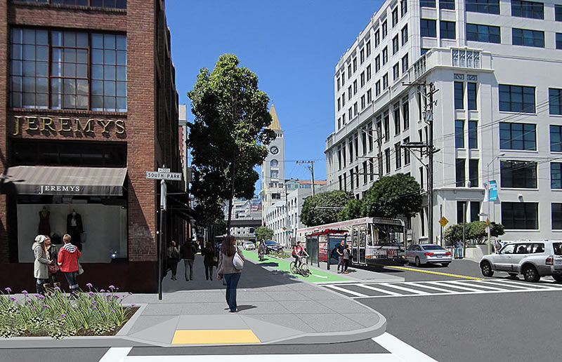
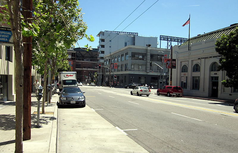
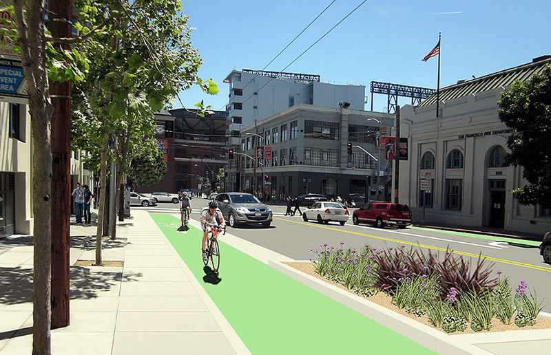
The Environmental Impact Report for San Francisco’s proposed Second Street Improvement Project, which intends to transform Second Street, from Market to King, into a pleasant “multi-modal corridor” and “green connector,” with separated bike lanes (cycle tracks) on both sides of the street, a whole host of sidewalk and streetscape improvements and a complete repaving of the road, has just been published.
In addition to a widening of the sidewalks between Harrison and Townsend and installing cycle tracks in both directions along Second, the project would also install transit boarding islands with planted medians at most transit stops and eliminate two right-turn lanes at Harrison
The travel lanes along Second Street would generally be reduced from two to one in each direction and left turns would be restricted at most intersections.
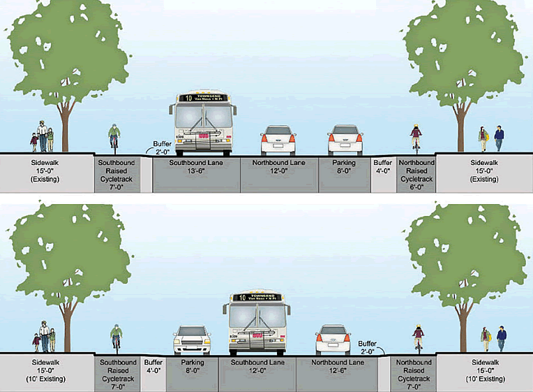
The project would limit general parking and relocate some commercial and passenger-loading spaces along the corridor, as proposed, which would result in a reduction of roughly 10 percent of the existing 1,700 on-street parking spaces within a one block radius of Second.
Assuming the project’s Impact Report is approved, the public hearing for which will be held next month, construction for the Street the Second Improvement Project is slated to start in early to mid-2016 and continue for approximately 1 year. The exact timing will be dependent upon the number of comments on the Impact Report generates and any challenges to which the City will need to respond.
Wonderful! now they just need to work on making some of these other SoMa streets not feel so wide, dirty and industrial. SoMa has the possibility of having some truly grand boulevards if people will let it happen. Folsom is going to be getting a lot more trees with all the construction going on, I know that much.
SOMA is not Dallas
Isn’t the Caltrain extension going underneath 2nd, from Townsend up to the Transbay Terminal? How does that project figure into the scheduling of the 2nd street improvements?
The Caltrain extension is planned as a bored tunnel; it shouldn’t have much of an impact the surface of Second Street.
Its my understanding that there’s two ways to put the tunnel in. The first is as you mention, a deep bored tunnel – not disruptive to the surface but more expensive than the second, which is to bore less deeply and is less expensive, but also disruptive to the surface.
From where I see things, it looks like getting CalTrain to the Transbay Terminal is more about cost than anything else. So you would assume that they would go with the method that is less expensive, but they would be tearing up the 2nd street improvements and have to redo them.
I think it’s supposed to be cut and cover, so it’ll have a major impact.
It’ll never happen, however.
Holy molasses! When I bought a condo on 2nd street in 2000 they were talking about this. Now, 15 YEARS later they’ve released an EIR?
Can’t this city do anything in less than 20 years?!
Man. I’m saying.
I know the GOV is slow with everything, but I can’t imagine that all of the (negative) public commentary does much to help.
Hopefully they ban left turns from South Park into 2nd St northbound.
This will add a light at 2nd and South Park. It was the most requested improvement. With proper signalling, that should make the pedestrian crosswalks there much safer and still allow the left turn from South Park onto 2nd. A bigger problem for traffic would be the turns from 2nd to South Park, as this plan will only have one lane of traffic in each direction.
I think it’s jolly fun how certain people on here think SoMa should have the density of Manhattan, but the street grid of Mayberry.
In this case, the result is just as much concrete as before, but with ugly planter spaces (that will be neglected) and greatly diminished traffic capacity – at a time when both office square footage and the number of residential units in this area is exploding.
I agree. Wait til the traffic congestion gets worse and worse thanks to fewer lanes for the over entitled cyclists.
terrible solution.
I never understood the idea of an entitled cyclists. It makes no sense to complain about traffic congestion, when driving a car in a dense area is the only thing causing the congestion. Congested for whom? If you don’t like the congestion, then get out of your cars, and find another way to get around, as their really are so many smart and easy ways to get around this city, if you get out of your car. Coming from LA, and moving to SF 25 years ago, I have embraced the transit friendly, walking friendly and cycling friendlier streets, and as a result, I have learned that getting around this city is easy, fast and cheap, when you get rid of the car. The entitled people aren’t the cyclist, but the motorist who refuse to give up their entitlement, and carry on driving in congestion, and complaining about it, as if doing so will some how change the density of this city to one that will become amenable to cars. Go to LA and other car oriented cities, and you quickly see that the car route is a failed urban planning nightmare. Adding freeways, wider lanes for cars, expressways, etc, and removing historic transit has made getting around next to impossible because the easier you make it for cars, the more people drive, filling the streets with even more cars and worsening congestion for everybody. There need to be options besides the automobile, and many have already accepted and figured this out, except of coarse the entitled motorist, who take no personal responsibility for the consequences of their driving, such as pollution, global warming, “oil wars” in the Middle-East, and grid-lock on roads with too many cars. Open your, if you can see through the soot coming out of your exhaust pipe.
When SF moves behind 3rdworld public transit, then more people will get out of their cars. Bike lanes are not the solution as only 2.6% of commutes are by bike and that number will never get above 6-7%
^^ this, exactly. I’m not going to bike from the Richmond to SoMa, and the transit options are ridiculous — 45+ minutes by bus to go 4 miles. If there were an E/W subway under Howard or Folsom and a N/S subway under 1st or 2nd, etc., then maybe all this surface traffic calming stuff would be justified. (or at least would not have such negative effects)
And again, go to my original point. When was the last time some of you were in Manhattan – or London, or Chicago downtown, or Sydney CBD? Even these cities, with far more elaborate public transit, aren’t car-free utopias; far from it, they are cheek-by-jowel with cars and taxis and busses, on multiple-lane streets.
You could ride a bike from Richmond to SoMa. I ride a lot farther than that when I need to / want to.
I’ve been to Manhattan very recently; personal cars are not the main mode of transportation. The Citi-Bike program is by far the best way to get around all of mid and lower Manhattan, it is ridiculously fun and way quicker, better than any alternative (assuming its not raining or snowing, then you need the transit).
I ride a lot. I used to occassionally ride from the FiDi to Mill Valley, when we lived there. *occassionally*. It’s not something I, nor most people, are going to do on a regular basis. EVER.
I ride a bike from the Richmond to Soma. It’s totally workable as an everyday method, and it doesn’t require you to be a hill-climbing dynamo. It keeps getting better– from the protected lanes on the three blocks of Oak to various intersection treatments, it’s clear that people have put a fair bit of thought into improving it.
@sierrajeff – it probably takes you 45 min to drive South of Market from the Richmond. Why would the bus be any quicker?
Urban cycling for commuting is, and will remain, an option for a very small percentage of the SF population; mainly that of young, fit urban men (not all, but most). Nothing inherently wrong with that option, but want many of find wrong is the incredible amount of money being spent for bike lanes and the seriously disruptive change to traffic patterns; increased congestion and lack of parking.
All this while all the city can show on 2nd street is an outmoded, slow,clunky bus down the middle. It’s not much beyond 3rd world mode.
You’re wrong about the biking demographic Futurist. I keep an eye on my fellow bike commuters and see a lot of gray beards beneath the helmets.
Discard your prejudices and open your eyes.
@milkshake — really, you come back with “gray beards”? Discard your misogyny and open your eyes. You essentially proved @Futurist’s point.
I think the real issue here is the Bay Bridge traffic. I can’t see it decreasing at all since there’s no proposal I’ve seen or heard of to reduce the volume of cars, trucks, and buses on the bridge. All that traffic trying to get off of and onto the bridge from a radius of several blocks around 2nd street – with two lanes removed will be much more brutal than it is today. Second street is a key feeder for getting onto and off the bridge and into FiDi.
And I’m talking about normal daily traffic. During commute, its much more congested.
Even if you never drive, congetstion is a terrible thing. More air pollution and far less safe to be a pedestrian or bicyclist. The ultimate goal should be to have everyone in all modes of travel move as safely and quickly as possible. Unfortunately the 2nd Street plans looks pretty but causes more problems than it solves.
Thank you, Urban Planner, for your comment.
great points! drivers shouldn’t complain about congestion – they ARE congestion
Agreed. Also, it’s not like they’re making any transit improvements that will deter people from driving. (Caltrain extension to the TTC is a looooooooooong ways off.) Speaking of transit…with one lane of traffic in each direction, MUNI will operate even more slowly as it gets stuck behind other vehicles. You’d think they’d create transit-only lanes, but it looks like the pro-bike forces win out yet again (let’s see how many of them actually use the dedicated lanes.)
The reverse is even more true. You’re going to see traffic backed up stopped behind buses as they load/unload in the only lane for vehicular traffic in each direction.
Yes! few will use the costly bike lanes, but they insist and bully the SFMTA they MUST HAVE THEM.
“costly” bike lanes? Yuk yuk. They’re one of the cheapest options in the transportation toolbox.
How did you feel about the cost of the 80/880/580 interchange remodel over in Oakland?
To clarify, what about the approx. $55m SF has spent so far, or more on bike lanes in The City where only about 3-4% of the population uses them.
And what about the proposed cost of $500m ++ to add a bike lane to the bay bridge?
Yes, that is COSTLY.
The half billion dollar proposal for a bike lane on the west span is kind of an outlier, don’t you agree? And if you’ve been paying attention you know that I oppose it too. Also how many miles (or yards if it makes more sense working without fractions) of freeway do you think you could buy for $55 million?
Stick to reality.
Less than 1% of the SFMTA’s budget is devoted to bicycle projects. On the other hand, I sure love the new Doyle Drive’s protected bike lanes and its transit only lanes have really sped up my commute. And the (non-existent) bike lanes on the recently redone stretch of Divisadero have made the street so much safer for my kids.
$55 million lol. How about that lovely $7 billion we just spent on half a bridge?
The bridge that has a bike lane and collects tolls from cars and trucks but not from bikes. If all the cars on that bridge were changed into bikes, we would still need the bridge and it would still have cost billions of dollars to build, though it would only need to be about two-thirds as wide.
The direct cost of creating bike lanes tends to be low because most are built by repurposing existing road surfaces. The accounting for this project doesn’t debit the bike budget for the existing investment in or value of the 20-foot wide portion of 2nd Street that this plan will dedicate to the exclusive use of cyclists. It is not like there is some bike account that is buying the travel lane asset from some motor-vehicle account. And ROI arguments over the pavement of 2nd Street would never result in bike lanes, maybe a dedicated bus lane, but not a bike lane.
Without a full accounting, money arguments are specious at best and usually just another way to avoid the real issues.
Besides, the indirect costs are more important and more why we should or shouldn’t do this. And those include safety. Look at how quickly SF put in the Folsom bike lane after a tragic death there. They didn’t wait until there was a repaving project to bundle it into like they are with 2nd Street.
For all the posturing about how wonderful this will be, the facts are that 2nd is one of the least used bike routes in the northeast quadrant, per the last bike count. Where is the urgency to convert traffic lanes to cycletracks on all those streets with more bike riders than 2nd? Just about every intersection on 2nd is already congested to unacceptable levels according to SFMTA. And this plan will make them even worse, according to the newly released draft EIR.
and how many billions were spent on the new Bay Bridge? or Doyle Drive? Freeway projects get lots of money. $55MM is a drop in the bucket.
Mark, TEP is already improving Muni service. The SFMTA is implementing other measures to speed up Muni service (like double berthing of trains in the subway, buying more buses and LRVs, and hiring and training more operators). Muni is improving. And a second BART tube (although it is decades off) will help, too.
From a quick scan of the draft EIR (400+ pages), it looks like they only considered two alternatives to doing nothing and both have dedicated cycle tracks. If that is the case, then this is a rigged document. Perhaps the subtitle is a not so subtle clue: “Supplement to the San Francisco Bicycle Plan Environmental Impact Report.”
Alternative 1 is do nothing. Here are partial descriptions of the other alternatives from the summary:
“Alternative 2 would include a northbound and southbound Class II bicycle lane, except along two blocks: northbound between Stevenson and Market streets and southbound between Townsend and King streets. Bicycle sharrows would be added to the travel lane at these two locations.”
“Under Alternative 3, Second Street would include northbound and southbound Class II bicycle lanes, from Market to Townsend streets. Between Townsend and King streets, a northbound bicycle lane would be provided, and bicycle sharrows would be added to the southbound travel lane. The proposed bicycle lanes would be accommodated by removing one travel lane in each direction along most of Second Street.”
Wow! You can’t be more rigged than that! Our tax dollars at work for a small but vocal minority — welcome to SF. Sometimes I hate this City
Love being hijacked by the powerful lobby of 25-45 yo white guys from bike coalition that represent the interest of 3% of the city. That’s the definition of entitlement
Then be sure to file your public feedback on the report! Go on the record, not merely the SocketSite comment box. Common sense has to stand up and be heard.
Is it really too much to ask for just ONE street south of Market to be redesigned in a manner that makes bicycling safe and encourages everyone from age 8 to 80 (and beyond) to cycle if they’re able to do so? SOMA and Mission Bay are adding thousands of residents – might as well encourage and foster safe, multi-modal options. Certainly in many European cities but also in cities like New York, Chicago, and Vancouver proposals like this are considered common sense. Do today’s bicyclists and all potential bicyclists deserve to continue to be marginalized and at constant risk of injury and death? Is it so hard to share ONE street in a manner that truly benefits and promotes all modes of travel?
4th St could accommodate a dedicated two-way bike lane. It is flat and straight and goes directly between the Caltrain Station and the heart of Market St. It will have underground train service to relieve some of the load from the surface. It already has a bike lane in Mission Bay. The existing design is a dangerous relic of the car-centric era, with two-lane wide turns at many intersections and two lanes feeding a one lane fwy on-ramp at Harrison. It could even be made a two-way street with dedicated cycle tracks and dedicated turn lanes (right on Mission, Howard, Harrison; left on Folsom, Bryant).
It also doesn’t directly feed traffic onto the Bay Bridge ramps which has the worst congestion in the Bay Area resulting in the most backup road surfaces in SF.
In all these ways 4th st is a better choice than 2nd for dedicated cycle tracks.
Jake – On the surface 4th does look like a better option. I’d prefer putting bike lanes on 4th too if it were feasible. The hitch is that there’s a freeway interchange with I-80 on 4th. Freeway interchanges and bikes do not mix well. Actually freeway interchanges alienate anyone not in a car. Try walking through the ramp side of 4th or 5th under I-80 and you will see what I mean. 4th’s also connects to the quasi-onramp to I-280 that is King St.
A proper installation of bike lanes on 4th would be a lot more expensive than doing the same on 2nd. And it would interfere with 4th’s function as a feeder to two freeways. Motorists would scream. Actually entitled motorists scream whenever any roadspace is allocated to bicyclists but doing this on 4th would get the realistic motorists (and even people like myself) screaming.
I really don’t understand all of this kvetching over allocating some of the space on just one of the many parallel streets in this area. C’mon, there are plenty of other options for motorists to avoid 2nd.
@MoD, how about 3rd as an alternative for bike lanes? 2nd is also a freeway feeder (the Bay Bridge) and just as messy as 4th. Traffic to/from the bridge use 2nd and Bryant, Harrison, and Folsom. And as someone who walks 2nd quite a bit seven days a week, its no fun crossing those particular intersections as people race to get on/off the bridge. And its worse during commute and pre/post Giants games.
Can’t Think of Cool Name – The only issue I can see with 3rd is that it is one-way. Splicing a 2-way bike route into a one-way street is suboptimal and might present a safety hazard since people might not expect bike traffic coming from the opposite direction. Then there are awkward transitions into/out of the counterflow lane at intersections.
And they are exactly the demographics of the entitled urban bike riders.
Except of course when it gets too cold out or it rains.
If we keep repeating words like “entitled” does that make the allegation more accurate? Or does it serve to further alienate others from your cause? Entitled is defined as: believing oneself to be inherently deserving of privileges or special treatment. If we’re going to toss this word around, please consider the position of motorists in contemporary U.S. society. Motorists can pollute with impunity, no questions asked. How many Spare the Air days have we had this winter? How much has our planet been warming? Are bicyclists really the enemy?
Have any of you driven down 2nd Street during the morning or evening commute? It is already essentially a 1 lane street (or blocked entirely) for through traffic because of unloading trucks, Bay Bridge delays, cars blocking the box, and left turners stopping all traffic. To drive 5 blocks without stopping requires constantly changing from lane to lane to avoid these vehicles. A single vehicle lane that encourages through traffic due to intersection redesigns, elimination of left turns, etc. will help people actually MOVE. This plan benefits people in cars, buses, on bikes, and on foot. Love it.
@Hunter, I hear you, but the issue I have is the growing volume of traffic isn’t really taken into account in the plan from what I can tell. The area around 2nd street has become very dense, and getting more so by the month – hence there’s a lot more traffic traveling 2nd today since I’ve been observing it over the last almost ten years. The volume of traffic using 2nd today as a four lane street still causes congestion. Taking away two lanes will not solve the volume/density/congestion problem.
Like water, the excess traffic volume post the street change (if it happens) will find its own level, flooding onto other nearby streets. 2nd street, now as a two lane street will still be congested. Now other streets may very well be more congested than they are today.
On top of that, as noted elsewhere in this thread, the mechanics of how the street is proposed to function is based on every driver utilizing 2nd street being on good behavior all the time, every day.
I do believe 2nd needs a re-look, but not as a traffic calmed street in a very dense community.
I’ll propose Alternative 4: Remove parking on 2nd Street. Widen sidewalks for better pedestrian traffic with proper bus stops cut into the sidewalks so busses don’t let people off/force people to get on directly in the street. Find areas on 2nd for temporary parking for daily deliveries to 2nd street businesses. Keep the 4 lanes as a north/south thoroughfare from Market to King to improve flow of traffic from and to the Bay Bridge and through the neighborhood. Forget the bike lanes – move them to 4th street.
Looks great. I can’t wait.
Polk Street near Market still looks good. Hoping Sierrajeff’s pessimism turns out to be misguided.
it is misguided. These street improvement projects will be great.
Street improvements do not necessarily HAVE to remove traffic lanes to accommodate minimal cyclist use.
Some of use would like to see more than just “minimal cyclist use”.
Maybe they don’t have to, but the definitely should. Just because you don’t ride as a mode of transportation doesn’t mean it isn’t the best possible future of transportation. You’re free to sit in your car in traffic.
And with the reduced lanes of traffic on 2nd street, it will mean longer sitting times in the car in traffic.
Great!
Fortunately for those who don’t like bike lanes, there’s still Spear, Main, Beale, Fremont, 1st, 3rd, 4th, 5th, and 6th without any. So you are well taken care of.
Exactly. There are two main bike route over SOMA. Embarcadero and 7th/8th St. There is pretty much nothing in between that accommodate bikes. For cars the all these major through fare 3rd, 4th, 5th, 6th, 7th, 8th, 9th, 10th to choose from.
The southern half of 2nd actually have fairly light traffic. Most of the rush hour traffic are to and from bay bridge.
Bryant and Harrison are in the “southern half” of 2nd street. Those are the two most congested intersections on 2nd and they will both be worse because of this plan, according to the EIR.
I’d add to @Jake’s comment that during Giants games, King, Brannan and Townsend, all “southern half” streets will be worse as well…
agreed.
Agree with Easy. Planners in many cities (eg, Congestion Charge in London) are trying to reduce car use in town. Although it offends the Mr Toads, I think this will be a welcome improvement.
The 2013 bike count for 4-6PM at 2nd and Folsom was 278 bikes. That is less than 5% of the capacity of the dedicated bike lanes proposed in this plan.
By comparison, from 4-6PM, more than 11,000 cars use the nearby I-80 ramps to get on the Bay Bridge headed east (Bay Bridge Corridor Congestion Study – AC Transit). This is the most congested commute in the Bay Area.
Tail wagging dog….
Yet it’s the Bay Bridge that’s congested, and that’s not changing anytime soon. Optimizing SF city streets for car traffic headed to the bridge won’t help. However, optimizing SF streets for non-car traffic can help by making it easier, safer and more pleasant for people to avoid using cars altogether. And increase total capacity to boot.
This plan is not “optimizing SF streets for non-car traffic”. It actually impedes MUNI on 2nd according to the EIR. And MUNI carries more people on 2nd than bike there. All the pedestrian improvements can be made without creating cycle tracks.
This project will certainly have an impact on SF streets in eastern SoMa. I’ll leave out some of the unpleasant details from the EIR, including how this aggravates Giant game days.
The EIR classifies each of the following as “Significant and Unavoidable impact for which feasible mitigation is not available”:
The proposed project or project variant would cause the level of service to deteriorate at the intersection of
– Market and New Montgomery
– Mission and New Montgomery
– Harrison and Hawthorne
– Harrison and Second
– Howard and New Montgomery
– Townsend and Second
The proposed project or project variant would contribute cumulatively considerable traffic to the unsatisfactory operation at the intersection of
– Market and New Montgomery
– Mission and New Montgomery
– Harrison and First
– Harrison and Second
– Bryant and Second
– Bryant and Third
– Brannan and Third
– Townsend and Third
– King and Third
– Bryant Street/Fifth Street/I-80 Eastbound On-Ramp
I’d toss in added congestion and deterioration of service on Beale, Folsom, and the Embarcadero as traffic will undoubtedly reroute on those streets as well.
Vehicular traffic of all kinds will not be going down any time soon in this area, and will be going up with the addition of all the new construction going in within a block or two of 2nd street. A certain percentage of the people living in or working in those new buildings will undoubtedly be driving. And those buildings will be getting all kinds of daily delivery services.
Thanks for the data showing how ridiculous this plan is
We can decry this before it’s even built and pretend that it’s the result of a vast Bike Coalition – city government conspiracy or we can be real and recognize that a mere one of dozens of SOMA streets will be redesigned in a manner that gives bicyclists a bit of elbow room. Protected bike lanes here will be a big success. I’m as pro-transit as they come but I know that there are dedicated transit lanes (which entitled motorists routinely block) one block over, and the design shown above will allow for faster and easier Muni boarding. Rapidly growing neighborhoods need to improve their transportation infrastructure and SOMA is one of the best suited SF neighborhoods for bicycling with its flat, wide streets. All that is needed are redesigned streets so that bicyclists aren’t subjected to being routinely buzzed or honked at. If bicyclists have their own, protected lanes they won’t be in the way of the legions of SF motorists who drive as if they’re on the run, recklessly endangering those few souls brave enough to travel by foot or bicycle. Build it right and they will come (the bicyclists, that is) – and then everyone will benefit, even the most diehard of motorists (as “their” streets will be less congested).
This plan will make the MUNI bus slower not faster on 2nd. From the EIR: “The sum of the delay for Muni Route 10 in both directions would increase by 1 minute and 27 seconds.” And that includes the time saved by reducing the number of stops.
By far the majority of all travel on 2nd St is “those few souls brave enough to travel by foot.” I do it every day. Anyone that stands at any of the intersections would know this. And none of the pedestrian improvements require taking away a traffic lane. That is only required to create the 20-foot wide section of road dedicated to the exclusive use of cyclists.
Why do advocates for cycle tracks on 2nd hide behind pedestrians and MUNI instead of making their case on the merits?
The plan is worse for public transit and motorist use, which represents over80% of use of this street. It is a neutral for pedestrians which make up 15% , but helps the elitist entitled cyclists. How can this possibly be approved?
As those familiar with Muni service know, 2nd Street has minimal service and is a much less important Muni corridor than 3rd or (currently) 5th Streets. However, I’d be very happy to have the proposal include transit only lanes, but even without them it will become a better street for transit riders with smoother service and easier rider access to transit vehicles. Motorists can keep the hundreds of other lanes they have in SOMA and avoid 2nd Street.
This plan gives pedestrians considerably wider sidewalks and shorter street crossing distance (that’s not neutral, it’s a huge win for pedestrians).
Bicyclists don’t have any street with protected lanes outside of Golden Gate Park, Crissy Field, and one brief stretch in the Bayview. Bicyclists have been second class citizens for decades now and even with this and other proposals, this is not going to change any time soon. SOMA’s multi-lane streets encourage high motorist speeds and discourage cycling. Furthermore, SOMA today is largely an unpleasant environment for pedestrians (with a plethora of exhaust spewing and loud cars, trucks and motorcycles) and there is no need for it to stay that way. Motorists may be content with the status quo, but everyone will benefit if our streets are redesigned to foster healthier and more environmentally sustainable travel. It’s unfortunate that some SocketSite readers feel threatened by that but I’m certain that they’ll enjoy the result of this fine proposal – especially if they will walk or roll down the new 2nd Street.
While I agree in theory, it seems to me that 2nd street was the wrong street to improve from a biking standpoint — there are a number of other streets that are quite a bit more flat and thus easier to bike. Additionally the bridge traffic on 2nd street can be horrible at times, it is backed up quite a bit more than streets just a few blocks away. That being said, I am not going to oppose any road diet in SOMA since you are correct about ridiculously high speeds of vehicles during non peak hours.
To be fair, since it sounds like you have never taken the 10 bus during commute hours, I am not sure if muni service can actually get much worse. A minute and a half is negligible here, the bus is constantly blocked by cars trying to do merges at the last minute to get onto the bridge and cars blocking the box. It can take 30 minutes to get from 2nd and Townsend to 2nd and Harrison.
“It’s already bad, so what’s the beef with making it worse?”
I can’t say if 2nd Street would have been a candidate, but can we really not close a single street downtown to car traffic?
Hyperbole. Then show us one street you would close to ALL traffic including deliveries and show us how it would work and how you would re-route all the uses of that street.
And we’re not talking about alleys.
I guess other cities are full of hyperbolists, then, because plenty of European cities close entire districts to car traffic. They permit deliveries off hours. They allow taxis to drop off people who can’t walk. Residents have permits to enter and exit the areas and they drive v e r y s l o w l y. You want to see how it works? By an airline ticket.
“European cities” can close streets to cars because they have extensive huge comprehensive public transit systems, with multiple subway, tram, trolley and bus lines. What I find strange about the battle against cars is that drivers are not given an alternative. I have lived in London and never owned a car nor felt I needed one, but with my multiple appointments as an architect in various parts of the Bay Area, I can’t afford the time of riding a bike out to the outer Richmond as an example. When visiting job site I am bringing drawings, sample boards, construction project manuals, my computer, etc.
I’m currently in Milan. have been her for 1 week. Love the city and would love for SF to model transport system based on here instead of an irrelevant city like Amsterdam.
Milan has many modes of transport. Great subway, great light rail, great buses. Plenty of people taking scooters, motorbikes and cars. A few bicycles here and there, but very light traffic for a city of 1.2M+. Havent seen more than a couple of dedicated bike lanes. Haven’t seen much argument between diff commuters. They do have an ambitious plan to increase bicycle us up to 10% mode share in 10 years,but I don’t think they’ll get there because public transport is just too good. They also charge 5 euros per day for cars entering city center which is not a bad idea for SF.
In SF, We need to build a subway, increase light rail and increase scooter motorcycle use. If there are “viable” alternatives, car use will decrease. Forget the push for bicycle lanes. It’s a waste of money and will just slow down everyone else, let’s get some balls in the transportation office. Imagine if we increased motorbike or scooter use from 1.5 to 5%, increased bicycle from 3-5% and built a subway on geary and van ness . Big change. We should make it city policy to increase motorbike usage. I may run for Eric Mar’s supe seat
I’d love it if there were subways under Geary, Van Ness, 19th Avenue and maybe a few other streets, too. If the political will was there, money for such projects could be found. But in the world we live in, most new subway infrastructure is decades off. Bicycle infrastructure is relatively cheap and much quicker to implement. By the standards of many European cities (none of which may be in Italy), what San Francisco is proposing is very modest.
Your trip to Milan sounds enlightening, moto mayhem. Do you not see anything problematic about increased motor bike usage? Are you not concerned about increased air pollution? I encourage you to have an open mind to see what the results of this 2nd Street plan will be.
Motorcycles pollute way less than 95% of cars. I have an open mind to increasing many modes of transit, including cycling in the right places. However we should focus on moving the most people through streets in the least amount of time and closin off car lanes when 80% of people drive or take a bus in favor of bike lanes which represent 3%, will lead to increased congestion, is not good policy and just plain dumb
The more I read Moto Mayhem’s posts, the more I am now convinced San Francisco makes the perfect motorcycle city! I am not sure why I did not think of getting a motorcycle myself sooner. You can park in almost any neighborhood easily, hills are no longer an issue, and bike theft is not as serious a problem with a motorcycle due to license and stiffer penalties.
The smart money is buying property on 2nd. This is going to be one of, if not _the_ the nicest SoMa neighborhood street. It’s too bad we have to wait so long to see the proof, but once this domino falls things should get better on a whole host of currently mis-purposed streets in SF.
This is going to make an impossible street worse, and will ripple throughout SOMA. We need to take back the SFMTA from the anti-car bike zealots and hand it over to people focused on mass transit instead of rich white people wobbling around on their trikes.
The sky will fall if this proposal goes through!
It’s too bad that the strategy employed to discourage car use is make life difficult for everyone who drives rather than make transit more attractive for those with options. I find it cynical and hostile for a city that pretends to be more idealistic and thoughtful.
Definitely not enough “carrot” for drivers
I’m sorry but motorists have been gobbling the vast majority of transportation carrots for over half a century now. Time to go on a diet.
Yeah, before those nasty automobiles, it was a nirvana of mud and horsesh*t.
What does that have to do with the fact that the Bay Area has catered almost exclusively to drivers within our lifetimes? Is this some kind of strawman?
And FWIW, I don’t think autos are nasty. Overused and oversubsidizsed, yes.
Could you show me any statistic that says that drivers are subsidized, and by whom? I have read the opposite on sites such as The Antiplanner. What has been subsidized for decades is public transit, usually by revenue created from drivers, don’t believe me, look it up on the SFMTA website, or the Golden Gate Bridge website which shows how auto tolls are used to subsidize bus and ferry service. I would like to see bike riders pay registration, neighborhood stickers, and insurance like the rest of us.
I don’t have the stats at my fingertips but will offer just one little piece of the subsidy: “free” parking. Who do you think bears the cost of providing that?
I would agree that free street parking is subsidized and would have no problem with expensive neighborhood parking stickers, parking meters, or other road use and parking fees. I also agree with the person who wrote that if we are going to remove parking on streets like Second or Polk, private parking garages should be allowed to be built and they should be able to charge whatever fee the market will allow. I would have no problem if the MTA decided that some of those parking revenues were used for transit construction as well. By the same token, I feel that bikes should be charged some type of bridge fee if the Bay Bridge decides to extend the bike path west of Treasure Island.
Anon1, The gas tax has long since fallen behind paying for highway maintenance and subsidies from general funds are required. (Please see: Pay More At The Pump? Finding Money For The Federal Highway Trust Fund, which states, in part: “The federal government spends about $50 billion annually on transportation, but fuel tax revenues cover only $35 billion, leaving the rest to general fund transfers.”) In other words, all taxpayers (through income taxes, etc.) subsidize highways. And locally, property taxes, sales tax, bond measures, etc. subsidize roads and highways. Of course, driving’s external costs (related to pollution, public safety and public health resources expended for traffic related measures such as collisions and their consequences, oil wars, obesity, etc.) are not paid for by motorists but are borne by the public-at-large (and future generations).
If you assume that 200 million people in the us pay taxes and the fuel tax shortage is $15B, that means we are have to pay $75 for the subsidy yearly. Big deal.
@Anon1:
” the federal gas tax, which hasn’t been raised since 1993 and loses purchasing power to inflation every day. These two lost decades of road taxes are the reason the Highway Trust Fund, which is supposed to cover road costs, is expected to fail in 2015.
Meanwhile, as Gomez and Vassallo point out, European countries take in far more road revenue than they spend. As a result, the road system in Europe can be (and is) used to subsidize other public programs. That’s the opposite case of the United States, where general income taxes have subsidized the Highway Trust Fund to the tune of tens of billions of dollars in recent years.”
http://www.citylab.com/commute/2013/09/these-2-charts-prove-american-drivers-dont-pay-enough-roads/6917/
Wow. You really are quite angry over car ownership and driving in this culture, aren’t you?
And yet you own one, use our road and probably also use the “free” parking on our streets. Your extremism seems to know no bounds.
What’s up with the crazy untrue allegations this week Futurist? You used to post less offensively. And you might want to follow up here too.
I’m pretty sure my bike arrived at my bike shop in a truck. Same with my organic locally grown apples. And my medicines. I’m pretty happy the automobile and the truck exist. I love protected bike lanes as much as the next cyclist. But most of the proposals aren’t pro bike, they’re anti car.
There are a hundred things we can do to make everything more efficient, such as protected right turn arrows, so cars aren’t waiting for pedestrians all the time at places like 4th and market. We should put in bike lanes and then mostly get cyclists out of traffic lanes (yeah, I know the law.) We should build a couple of parking garages and then make dedicated bike lanes on polk. But mostly the cycling advocates are anti car, and as a cyclist, most of the crazies here, and elsewhere, don’t speak for me.
Well said.
This is a tired old strawman. No-one is saying that motor vehicles aren’t useful. What is being said is that a little of the assets allocate for motor vehicles need to be reallocated to enable better alternative transportation. The fact that there’s a conflict on those resources doesn’t mean you can equate pro-bike and pro-walk with anti-car. It is just some facets of this transformation are somewhat of a zero sum game.
We might be in agreement on off-street garages on Polk though. I’m for that so long as the garages are privately funded and operated.
Actually people are calling cars murderous death machines or something like that. I remember when I took a couple of b-school classes. As an engineer I tended to look for solutions in which everyone benefited. But what surprised me about the b-schoolers was the intense desire to beat the other guy, not increase the overall value of the deal. I see a lot of that in bike related negotiations. Bike lanes for a parking garage. Protected right turns for cars in exchange for dedicated bus lanes. There’s a ton of inefficiency in our transit network and it’s happening across all modes. There just seem to be so many stupid things with our transit infrastructure that we can solve by simple trade offs and redesigns, where everyone wins.
Well, some of us get labelled as Pro-car, anti-transit, which couldn’t be further from the truth. I am pro transit and clearly pro pedestrian as well as think we should not make it city policy to make it hard for drivers without a viable alternative. This plan is a case in point. The thing that bothers so many of us the catering to the white male gang of bicycle coalition which seems to have such power to influence our unproven and untrained city transportation leaders. This plan will slow buses and cars. Making it a nightmare for the vast majority in order to serve a tiny minority just doesn’t make good policy. Private vehicles will never go away. They are growing in numbers. Hopefully we will get away from fossil fuel, but the cars of the future will need lanes and space too
Yes. A very appropriate and real observation.
And I would love to see several of those garages in neighborhoods that severely need parking, since parking is being lost to wasted cycle lanes. And yes, those garages should be publicly funded.
I was vacillating on the idea of publicly funded garages until I realized two things:
1) they would bring tourism money into our commercial districts – something we need as a (the) center of culture for the bay area. We frequently forget that we do depend very much on the rest of the region for our local economy.
2) we could get a ton of protected bike parking out of the deal, so mine won’t be stolen again. We could even charge for it and make money, the same way we do for car parking
Yes, the publicly funded garages make a lot of sense, as you stated. I agree. Several were built in Santa Monica adjacent to the 3rd St. Promenade and are heavily used and very convenient. AND the allowed 3rd St. to become ALL pedestrian; very human scaled, tons of retail and restaurants and a great place to hang out.
We don’t seem to understand that concept: that of creating something (parking garages) to get something (successful pedestrian way). The anti-car rhetoric here and in SF is just as loud as ever; only full of sound and fury with no sense of reality. It serves no purpose, only to further alienate each side.
We have a BOS and Transit authority under the bullying and pressure of a small, but vocal group: Mainly the SF Bike Coalition who’s sole purpose is to create their own small minded agenda, that of little used bike lanes for the benefit of a small minority, creating many more problems for our roadways and traffic congestion.
And yes, they really are “protected bile” lanes and nothing more.
I lived in Sunnyvale/Santa Clara for 4 years before moving to SF. We didn’t even know there was a subway here. And BART closes down at midnight, so its not like you can take public transit if you think dinner is going to run late.
In other posts, I’ve mentioned that the lack of parking is a problem for my biomedical company. Techs servicing out equipment circle for 30 min to find parking. If we are lucky, they don’t bill us for that time. I probably think parking should be more expensive than you do, but it is the dominant mode of transportation, and it will be for a very long time.
SFMTA owns and operates 38 parking facilities with over 15,000 total spaces (namelink for details). Two are on Polk and many others are clustered around Union Sq and downtown. They even have some electronic bike lockers at three City-owned downtown garages.
There’s more than 60k publicly available off-street parking spaces in the downtown/northeast area plus SoMa. Without them many of the car commuters would have no place to park. Enablers of commerce and congestion. Your tax dollars produced a nice map of all parking in SF:
http://sfpark.org/wp-content/uploads/2014/04/ParkingCensusDataMap.pdf
World class city, amirite
An excellent design moving forward, that’s great to see. It’s too bad it’s taking so long, but it’s a complex situation. Widening the blocks of narrow sidewalks so the entire length of Second from downtown to the ballpark will have generous space for pedestrians and trees is brilliant: thank you Supervisor Kim. Providing protected bile lanes on this critical link in the SF bike network is wonderful. Sharing (street space) is good!
Sharrows are your friends.
“protected bile lanes”
well said
perhaps the BOS can rename one ‘The Jane Kim Memorial Bile Lane’
kinda chokes the throat, just like the roadway
Agreed that sharing street space is good – when it makes sense. This plan makes no sense.
Kim certainly does spew a lot of bile. Thx for pointing it out david
Bile lane – ha! ha! Bitter taste in mouth. Better check the gall bladder to make sure no blockages.
20 years ago all these people against these streetscape improvements would have been arguing to preserve 480.
I’ve lived in the affected area for over 20 years and I was in favor of tearing down 480 and the restrictions on car traffic and creation of bike lanes on Market. I also voted to remove the Central Fwy north of Market. I’ve written on SocketSite about the vital need for making the streets safe for cyclists, and lauded the bike lanes and other changes for bike safety at the wiggle, on Folsom, and on Townsend.
Practically no one objects to any of the streetscape improvements for pedestrians or for MUNI. Many people object to removing half of the through traffic lanes to create lanes dedicated to the exclusive use of a relatively small number of cyclists.
Why do so many of the advocates for cycle tracks on 2nd disparage opposing opinions and offering little more than patronizing platitudes?
Why do all the advocates for cycle tracks on 2nd ignore the many significant problems they will create as listed in the EIR and boldly hide behind pedestrians and MUNI instead of making their case on the merits?
Because there is no case to be made, except “we want it. Can we please have it? We deserve it. Cars are evil. We want to be like a less dense and less important European city”
Exactly. And let’s be clear; despite the money being spent on bike lanes, the reduction of on street parking, and the added congestion of fewer traffic lanes there has been almost NEGLIGABLE reduction in the NUMBER of cars on our public roadways.
Fact is, those cyclists who ride to work/commute ALREADY were doing that, long before the urban/hipster of bike commuting. The did not abandon, give up, or sell their vehicles, because for the most part they never owned one. They have not reduced the number of cars on the roads. They have simply, thru their loud tactics and “friends” in the right places, created more congestion on our streets.
And they will continue to use their bikes, although the percentage of users will not rise significantly, until they begin to settle down with a family/partner/spouse, buy property, increase their income, get older, and many will buy a vehicle to supplement their urban way of living.
Futurist, that’s just a load of prejudiced bunk. Characterizing it as fact doesn’t make it so. Try to see beyond your biases and seek actual facts.
Actually Futurist is right. Portland and Vancouver have both seen flattening of bike usage, if not declines. While dedicated “protected” bike lanes continue to be constructed in those cities, they have found there is only so many people that can or are willing to bike to work. Weather, transporting children, transporting larger bulky items, TIME!, health issues, etc. all come into play with deciding to bike vs. drive. I used to bike to certain locations before bike lanes were installed, and having the bike lanes has not changed my riding habits or increased my riding trips. I prefer to take quiet side streets instead of riding down busy commercial streets, even if there is a bike lane on them.
I just did a quick google about Portland Bike usage not increasing after considerable spending and found this article:
“Technically, Portland reached that wall in 2008, when the number of commuters riding downtown plateaued at just over 6% — but the city kept spending anyway.
Despite new and better cycle lanes, the number of work-day peddlers remained stagnant after ’08, even dipping slightly, while the number of cars stayed the same.
Stagnation, in the face of a landmark 2010 decision to invest $613 million into bicycle commuting, in hopes of increasing that ratio to 25% by 2030.
Six years later, the number of cyclists remains the same, and Portland is finally saying enough.”
Yes, I can confirm the bike commute to work share for Portland residents from 2008 to 2013, has held steady at about 6% plus or minus the margin of error, according to the US Census estimates. The change in the count of bike commuters is smaller than the margin of error, so there is no way from this data to know for sure if Portland had more or less bike commuters in 2013 than in 2008. All this tells us is that it was about the same 18k plus or minus 2k margin of error.
Here are the actual bike commute share percentage and count from the ACS Table B08006 for residents of Portland:
2008 6.0% 17,365
2009 5.8% 16,846
2010 6.0% 17,035
2011 6.3% 18.977
2012 6.1% 18,912
2013 5.9% 18,337
Thank you Anon1. Thank you Jake. And thank you Portland.
This is exactly what I have been talking about. A tipping point has been reached in Portland, and it’s good to see the citizens/voters have had enough of exorbitant spending to ONLY benefit a small minority of commuters.
Sorry to burst your little bubble MOD, but facts are facts. It’s not bunk.
Maybe we need some ballot measures here in SF to vote on whether bike lanes and money spent for them at defined locations are supported by the citizen/voters.
If Portland plateaued at 6%, and SF is at 3%, the naive conclusion is that SF should keep adding bike lanes for a while.
that would be naive, especially because Portland’s bike boom in the years 2002 to 2008 isn’t correlated with significant growth of their bike network. Nice animation of the growth of the Portland bike network.
Article at namelink has some theories, including that people started to move to Portland for the bike network: “Once a city becomes known as great for biking, it attracts people who like bikes.”
The two-thirds of SF residents never ride a bicycle and only 17% ride a bike at least once a week, according to the SFMTA. Once you realize that some of those 17% walk to work, some already use transit to get work, some work from home, and some need to drive to work, the remainder is 10% or less as the available population to commute to work by bike. I’ve previously gone through those stats in detail on SocketSite before and can do so again if there is interest.
Here is what I don’t understand: we are building new high-rise housing near work centers such as SOMA, all along Market Street, the Mission District, Mission Bay, etc., why is there such a great need to build more bike lanes? Do the majority of the bike coalition live in the Haight area? Presumbly the new housing will allow people to walk to work, instead of using MUNI, driving their cars, or biking. No one in my neighborhood bikes to work. Same thing with the Richmond and Sunset neighborhoods. I doubt the Chinese would let their children bike to work since they find it extremely unsafe. The only bicyclists I see are the occasional weekend racer guy and the errant college student.
US Census Explore makes it easy to see where the different commute modes are concentrated.
http://www.census.gov/censusexplorer/censusexplorer-commuting.html
Zoom to the map scaled to all of SF. Select the census tract level of detail for 2012. Then look at the map for different commute modes beginning with walk, then switch to bike, then transit, then car. You will see a progression of the location of greatest concentration as you change modes.
Walk is heavily concentrated in the north east quadrant, essentially the area within a 15-20 minute walk of the central business district.
The greatest concentration of bike commuters is in the next ring centered on mission-hayes valley, but spread through the relatively flat areas on the downtown side of the hills. This is more or less the drainage area of the old mission creek. The bike commute time from these areas to the CBD is about 15-20 minutes.
Transit overlaps with the core bike area and spreads past the hills, especially along the BART and MUNI train lines and along Geary. Transit riders tend to have longer commute times than those that walk or bike.
Car commuting dominates the huge outer c-shaped ring from the Marina through the western and southern areas all the way to Potrero Hill. I’m not aware of any census tract in SF where the number of bike commuters is greater than the number of car commuters.
BTW, far more San Franciscans work from home as commute by bike. The cheapest way to reduce commuting in San Francisco would be to deploy fiber to the home.
Thanks for the links, Jake. I’ve read many of your posts on biking but I don’t remember seeing evidence that adding bike lanes won’t increase usage. There is a plateau somewhere but it seems premature to call it in SF based on the numbers here: https://socketsite.com/archives/2014/12/employees-san-francisco-commute-work.html
THANKS to Jake for his many interesting posts, and especially for his providing links with actual statistics which bring much needed verifiable evidence to a topic that causes a lot of strong opinions and emotions right now. With car ownership increasing in San Francisco, we are all feeling the pinch as road space becomes more scarce. There was just an interesting article in the New York Times about how Uber drivers are taking away customers from Public Transit and walking, and how this is increasing road automobile traffic in New York. I wonder if the same is true for San Francisco? I know of a couple of friends who, like myself, used to take BART from SFO to the city, and who now all use Uber instead.
Let me get this straight. You’re saying that SF, currently at 3.something mode share, should stop investing in bike infrastructure because Portland stabilized at about 6.something in recent years? The same Portland that endures much less pleasant bicycling weather than SF?
Sure, there’s a saturation point for any adoption and you certainly can’t go beyond 100%. But using such a small sample from a city quite different is specious.
Thanks anon. The Portland example is a clear reason why we should not invest in more bike infrastructure in SF. The topography of Portland makes it much more amenable to bike travel, yet it plateaued at 6. SF will probably plateau around 5, and the money is not worth it. Even worse slowing down other forms of transport for bike lanes is REALLY REALLY not worth it. Jake, as always thanks for the stats.
@ MOD. well, you can see that MANY others also feel we should not invest, or certainly modify our investments in future bike infrastructure. There are so many reasons now show what it does not make sense on 2nd St, and other streets. It’s overkill. It’s a waste of money, and it serves a VERY small part of our population.
@MoD, I’m not personally advocating stopping bike lane installations in the city. What I’m opposed to is the overall 2nd street plan, which just so happens to include in its plan a feature to swap out two very heavily used traffic lanes used by all forms of motorized vehicles for two very specific lanes used by just one mode of transportation.
And as called out by others, the statistics show that those two bike lanes won’t carry nearly the amount of people that the two traffic lanes planned for removal currently support. To me, as I mentioned elsewhere, this will be a severe congestion problem for the street and the surrounding vicinity due to the current and increasing density in the area.
That density and its associated congestion make 2nd street a street which I believe is not suited now or in the future for dedicated bike lanes. In my view, the bike lanes are simply collateral damage of a bad plan.
Bike lanes do have their place in the city, but not on 2nd street as envisioned in this plan.
I keep saying it anytime new bike lanes are proposed along with reducing traffic lanes and parking. There needs to be some investigative reporting on the people at the SFMTA. Are their backgrounds, education in city planning or are they just appointed by people in city government. I certainly don’t have confidence in any of their decisions. They describe it as traffic calming, but what they are creating is more traffic congestion in their hapless attempts at transportation planning. It’s just easier to devise plans with parklets, bike lanes and of course don’t forget the flags, they look so good in the drawings…the people at SFMTA or whoever comes up with this stuff really need to be investigated.
This plan would have made perfectly good sense – if it was implemented between 1989 and 1999, when the Embarcadero freeway was coming down and the ballpark was going up. I would have even encouraged it to be auto free, just MUNI, pedestrian, deliveries, bicycles and first responders – if the plan would have included reviewing 3rd, 4th, and 5th as well, providing an integrated north/south Eastern SOMA *total traffic plan* between Market and King.
The overall issue I have is timing. It’s too late now for this type of plan. The effected area is a much different landscape than it was even just 10-15 years ago. There’s too much density now in the vicinity of 2nd street with more coming in the form of the new condos and mid-rise office buildings now under construction or planned. Couple that density with the means for it to move about in any form and it should be no surprise to anybody that there’s congestion. And with that density not going away, the congestion that comes along with it won’t be going anywhere either. And to remove two lanes that serve the majority of people utilizing 2nd street (now and for the foreseeable future) with exasperate the problem.
If 2nd street needs to be rethought, it needs to be rethought around moving more and more people in the area effectively and safely. And I’d toss in a rethink of the previously mentioned 3rd, 4th, and 5th streets as well. I don’t understand how constricting movement via concepts like “traffic calming” in a dense, and growing more dense every day community solves the problem of moving lots of people effectively and safely.
So far, I haven’t found where we can publicly comment on this plan (if we’re even able to). If we are, does anybody know where this is? Is there an online option for commenting?
I realize I’m second guessing in advance if Sarah B. Jones will even listen to or respond to any comments sent to her. She should start by just reading the many comment here on SS who, for the most part, roundly criticize the proposed changes to this street.
Do they listen? Do they care?
Good point about the density. The bike coalition seems to think we live in a non important low density eu city, or a suburb where this might be a good plan. Suggest picking a good suburb to push these idyllic non reality based plans
In a way, the concept of urban biking really seems to be largely an idyllic, SUBURBAN concept: that of biking along marked trails, away from all traffic, riding past trees, lakes and ponds, enjoying the view of cows and sheep, while on your way to your suburban office park job looking to create the next great app for hookups.
I agree . A few new lanes in the presidio and golden gate park would be very welcome. Especially the presidio which is a nice place to cycle with few bike lanes
Cycle tracks will abound in Utopia, sometimes following beside the great high roads, but oftener taking their own more agreeable line amidst woods and crops and pastures; and there will be a rich variety of footpaths and minor ways. There will be many footpaths in Utopia. There will be pleasant ways over the scented needles of the mountain pinewoods, primrose-strewn tracks amidst the budding thickets of the lower country, paths running beside rushing streams, paths across the wide spaces of the corn land, and, above all, paths through the flowery garden spaces amidst which the houses in the towns will stand. And everywhere about the world, on road and path, by sea and land, the happy holiday Utopians will go.
A Modern Utopia, H G Wells, 1905.
Speaking of density, the area will be getting even more dense. I read today a San Francisco Business Times article that Boston Properties just grabbed 2.3 acres on 4th and Harrison. The CEO says that the opportunity exists for up to 780,000 square feet of office, residential and/or retail space.
Just more people coming and going two blocks from 2nd, and probably a decent number of them by motorized vehicles.
The EIR cover sheet says “Written comments should be sent to:”
Sarah B. Jones, Environmental Review Officer
San Francisco Planning Department
1650 Mission Street, Suite 400
San Francisco, CA 94103
or
sarah.b.jones@sfgov.org
_____________
The Second Street Improvement Project page (namelink) has contact info, including the email addresses for the long time project leads:
– Cristina C. Olea, Project Manager, Department of Public Works
– Ellen Robinson, SFMTA
_____________
2nd Street runs through some of the tallest zoning in all of SF. Within one block there are several parcels zoned for 700 feet and higher and there are many zoned for 500 feet or taller. California Street in the FiDi is the closest comparable two-way street north of Market for height and bulk within a block. Basically, eastern SoMa is zoned for more height and bulk than north of Market. And it also has the Bay Bridge and 280 terminus. Too many uses for too little street surface to achieve the bucolic vision of 2nd Street in the illustrations in this plan.
Since I do not commute to work via the Bay Bridge or SOMA or FiDi, I cannot offer much help in this area. However, I can attest to how unsafe it is for parked cars to be sandwiched between bike lanes and traffic.
Try driving inside Golden Gate Park in front of the Conservatory of Flowers where you have pedestrians, bicycles, parked vehicles, and car traffic with which to contend. Completely idiotic plan. Many times I have seen drivers (after parking their vehicles) dangerously swing open car doors into car traffic. I also see many bicyclists blow through stop signs and almost hit pedestrians trying to cross the street. And what happens when an accident does occur and the bicyclist is at fault? Who pays? I want to see license, registration, and proof of insurance.
Bike traffic should always be on safer more quiet streets. That is common sense. If not, why not put a bike lane on I-80 and Hwy 101 and 280?
You are completely right about one thing. It is fool plan to use our wonderful city’s largest park as a thoroughfare for the automobile. It’s a park, a place of beauty, and there a so many smart ways to get there and enjoy it: shuttles, buses, a nearby N Judah stop within walking distance of the entire park, which actually connects to BART and thus the entire Bay Area, and bikes are another pleasant way to see and access the park, and even a 59 year old lady like me can pedal around once in a while. I certainly feel safer getting on a bicycle these days with so many more bike lanes. Back in my day, riding a bicycle anywhere in San Francisco was a crazy affair. Furthermore, If I can take my entire class full of students there every year for our annual end of year party, using public transit and walking alone from downtown SF, bringing in on our party supplies and such, than everyone else can get there without a car. People speed through the park like it’s a superhighway, at speeds far exceeding the posted speed limits which are already too high, in my opinion. As someone who walks about everywhere I go in conjunction with MUNI and BART, I can honestly say I’ve never been hit or almost hit by a speeding bicycle, but I’ve had to jump out of the way of numerous cars both in the park and pedestrian crossings. California traffic law says that cars are not supposed to turn into a ped crossing, while there are pedestrians in it, yet everyday when I cross my 7th/Market intersection, I have to be careful that I am not run over by a car in hurry. My favorite thing is when a car tries to squeeze between me and an another pedestrian. Three days ago, I saw an elder gentleman get knocked over by a guy pulling such a maneuver down the street, and after he knocked him down, he kept driving off unaware of what he had just done because he was on his cell phone. You kids and your phones! Two guys on bicycles chased him and stopped in front of him and made him stop. I walked up to the young man, and gave him an earful. If ever I do get hit by a moving vehicle, and it’s likely to happen in this city of careless drivers. I hope I am lucky enough to get hit by a bike over a car. I don’t know why kids that are 16 years old should be given a license anyhow. I’d much rather see teenager on a bicycle than in a car. Just look at that statistics and look who causes all of the accidents: drivers under 25 and seniors to stubborn to admit that it’s time to stop driving. Getting hit by a bike sounds like a dream compared to being hit by two ton truck. Why? They move slower, they are lighter, and less likely to cause one deathly harm. Keep the cars out of the park, and learn how to take public transit. It’s an easy alternative, pollutes far less, reduces your global footprint, and it’s accessible to working class people. Only entitled Americans parade around the streets of parks and downtowns in their cars as if it’s a god given right. When your children and grandchildren have to deal with rising seas other catastrophic ecological changes, you can tell them how much you fought for the inalienable “rights” of the privileged drivers of 2015. Please people, be on the right side of history, or you put yourself at risk of being on the wrong side of history like so many others before you. Some of you who fight for the entitled right to drive remind me of governor Wallace fighting for the rights of “whites” to uphold the racist Jim Crow laws of Alabama in the late 1960s. Yes, I’m from the South, but I have learned to say so long to my automobile for sake of my grandchildren. I want them to have a future, and I want them moving around and off that coach and off that car seat.
there is no way i belive you are a 59yo woma. If anything, the elitist white male 25-45 yo cycling advocates who are taking over transportation have a lot more in common with the elitist southern firebrands of the 60s, although neither is a good comparison. history will side on the side of the common man, which these advocates dont represent
Of course it’s not a 59 yo woman.
1. the name is brand new here.
2. most likely a frequent SS commenter hiding.
3. the rambling on, ad nauseum.
Congratulations for being 59 yrs. old and healthy enough to be able to walk and/or bike around. I do not because of a medical condition. Even though I am much younger than you. Not all car drivers are reckless, careless or talk on their cell phones. If you get hit by a moving vehicle, hope that it isn’t because of impaired cognitive abilities.
Amewsed, that’s exactly it! Cars were a wonderful invention, and they make a lot of sense for people such as yourself because not everybody has ease at getting around. The problem is that most people that drive are healthy enough to get around by other means, and they drive all by themselves simply by choice, not because they have medical conditions that prevents them from getting around by other means. However, driving certainly does a lot to deteriorate the medical conditions of the people that drive. There are numerous health related risks that are attributed to car commuting including stress, anxiety, back problems, high blood pressure, high cholesterol, weight gain, sleep disorders, and others. When I stopped commuting to work by car, the pain in my back and neck almost immediately went away. I also had more time to do things like relax, and enjoy life, and my mood instantly improved. I initially switched to walking and using public transit, but now I also ride my bike instead of using MUNI, but still use BART extensively. Walking and biking wove into my life, and they have improved my health. The stress of parking is gone! The stress of traffic is gone! The back pain is gone, and the weight came off slowly but surely. I lost 20 pounds the first year, and another 15 the following year. I have kept the weight off too. What’s your health condition? Driving Also hurts the health of everybody by contributing to pollution, impacting the respiratory problems of everybody, and not to mention the ecological impacts that driving has on global warming. We can all do so much better for ourselves, for each other, for our kids generation, and for our planet. There is an interesting article on Time about the impacts on driving on the health of drivers.
I agree that being sedentary is unhealthy and is a big factor in contributing to heart disease. This isn’t just from car commutes but sitting in an office eight hours a day. Doctors recommend walking more. Bicycling and swimming are good as well for those who can manage it. Building up your core muscles leads to better balance. Simply feel better when you put in a good 10 to 20 block walk and eat fish, vegetables, and fruits. I have done it. Real commenter or not, you take the time out to write extensive comments while managing to deflect negativity in a graceful manner and that is appreciated.
I am sure you have more thoughts you wish to share that can enlighten us all. Please continue to do so.
My gosh – wanting to drive a car on a road designed and built for, er, cars is just like being a racist Jim Crow southerner! Kudos for holding back and not resorting to the usual Hitler/gas chamber metaphor. Your old lady restraint is admirable and sounds nothing like, say a 23-year-old judgmental bike loony, so, uh, there’s no way that’s who you really are..
When a city should be talking about more and better transit, we instead get all of the oxygen taken out of the room by bike nuts who think the only solution to congestion, whether on MUNI or in cars, is to construct “protected” bike lanes. Imagine if Leah Shahum and the SFBC were advocates for public transit instead of bike paths! There was an article in the Chronicle a while back about the revolving door between the SFBC and the SFMTA and how many public grants were handed out by the MTA to the Bike Coalition, especially for “safety studies” and “safer streets” proposals.
While it’s true that some cyclist ride like morons, and have no respect for anybody but themselves, are you suggesting that all drivers in SF are considerate, safe, and careful? Quite honestly, wouldn’t you rather have such reckless people on a bike rather than behind the wheel of a car, where they can do less damage to others, and more to harm themselves. FYI, I ride a bike, drive, walk and take public transit and lemme tell you something. The nuts abound in all locations equally. I know many motorist are fedup with cyclist and cyclist are fedup with motorist, neither group is created in a vacuum. They are all created in right here in the good’ol US of A. That’s the problem. That’s why everyone on here driver/biker/pedestrian/bus rider has such a hard time getting along. Bad cycling behavior doesn’t equate with a Utopia of good selflessness of drivers who stop for pedestrians. I wish we lived in such a mythical city, where drivers, cyclist, and pedestrians really looked out for everyone else instead of just number one, themselves. It’s not even about cyclist are good and drivers are bad scenario. Whether behind the wheel of a car, bike, skateboard, stroller, or sneaker, American people are not considerate of others when it comes to sharing space in big cities. The combative, individualistic, selfish nature of Americans, the most entitled people on Earth, is not conducive to any amicable behavior in an urban setting, whether you increase bike lanes or take them out, there is gonna be rudeness on all sides. Before there were bike lanes, drivers just fought amongst themselves, shot each other on the freeways, or bitched at motorcyclist, for riding in between the lanes. Now they have a new target for whom to pin their whoas: cyclist, but they still fight and honk among themselves too.
Now this sounds like Ms. Halldays angry sister. (I’m talking ’bout Global Warming stops…). Your rants just seems to be random typing.
Focus! Focus!
The essential and ONLY issue really is this one: We are NOT adding car lanes and widening streets for cars which is causing much more heavy congestion for the cyclists. We are not making their commute slower, are we?
What we are doing is allowing the SFMTA and the DPW and The Planning Dept. to be controlled and bullied by the 3% of cyclists who want to increase congestion for the rest of us.
JR Bob Dobbs. Learn your history. The entire core of the city and all of it’s surrounding central neighborhoods were populated with about half a million people by 1920. Only the wealthy elite had cars then, and most of the people in SF got around by transit, and foot. This is why most houses in these areas don’t have garages. Victorians, for example need to be raised on stilts and have garages added. None of them came with them. The cities streets were initially designed for horses, carriages and walking. There is some cool footage of the 1906 earthquake that shows peopling walking down Market street, avoiding horses, carriages, and trolleys, and bicycles, but virtually no cars. Only later were the cities streets redesigned for the addition of cars, and only a few. It was Golden Gate and Van Ness first. Now they are being redesigned again to conform with the environmental reality that we are currently faced with on the planet. We need to reduce driving because it is not a sustainable way to get around in cities. Driving and cars=global warming, sprawl and traffic. There are not an endless supply of natural resources to build cars, and fuel them. Denial is hard to overcome, and eventually leads to anger, but I assure you that eventually you will reach the place called acceptance. Keeping working at it.
@It’s, I think you make a valid point for improving/expanding mass transit – which I’m all for. To me, its the only mode of transportation I can think of that can scale to serve the needs of a growing population (commuters and residents) in the city.
NO. Not true about Victorians not having garages. Many did, with dirt floors, for the carriage or wagon. The houses were not raised up on “stilts”. Most Victorians were built with the main floor up ONE floor from the grade. Later on those dirt floor garages were just converted into car garages.
Get your facts straight.
Amewsed, makes a good point. There are so many bicycles that ALMOST hit pedestrians, but almost is not quite the same as actually hitting a pedestrians. There are three people a day that actually get hit by cars in San Francisco. That’s an astonishing and scarry statistical fact,
SF pedestrians are much more likely to encounter cars than bikes because there are at least 20 times as many car trips in SF as bike trips and car trips travel a farther distance on average. We are comparing the most common mode of transportation in SF, private automobile, with the least common, bicycle.
Fortunately, none of the pedestrian improvements in this plan require taking away a traffic lane. That is only required to create the 20-foot wide section of road dedicated to the exclusive use of cyclists.
Also fortunately, driveby trolling is neither astonishing nor scary, though we seem to get hit by it daily.
Many more cycle tracks are being planned for this neighborhood. The following is from the appendices to this EIR (250 page pdf at namelink), which include the Second Street Improvement Project Transportation Impact Study, July 7, 2014.
“As part of the planning process for the Central SoMa Plan, SFMTA and the San Francisco Planning Department propose the following bicycle improvements in the vicinity of the proposed project:
– Upgraded bicycle facilities would be located along Folsom Street from The Embarcadero to Eleventh Street.
– Upgraded bicycle facilities would be located along Howard Street, from Third Street to Eleventh Street.
– A new one-way cycle track would be located along Third Street, on the west side of the roadway (left-hand curb lane).
– A new one-way cycle track would be located along Fourth Street, from Market to Harrison Streets, on the east side of the roadway (left-hand curb lane).
– New one-way cycle tracks would be located on Brannan Street from Sixth Street to Second Street.”
More than likely the “Upgraded bicycle facilities” means converting the current class II bike lanes into fully protected class I cycle tracks, such as are proposed for Second Street.
Thumbs down on the Brannan and Folsom plans if they require removing lanes to install bike lanes.
The stretch of Brannan cited is already congested during commute with traffic exiting 280 at 6th and eastbound Brannan traffic trying to get on the bridge at 5th. After 4th, it starts to back up again just east of 3rd for traffic using 2nd to get on the bridge. With two lanes removed, I can see congestion on Brannan eastbound from at least 7th to 2nd.
I know less about Folsom, but the few times I’ve been on the 12-Folsom in late afternoons heading east there was plenty of slow moving traffic, I’d say from 5th or 6th trying to get on the bridge from Folsom just past 2nd.
FWIW, the transportation analysis predicts the 5th and Bryant intersection will be made worse by this plan. Imagine how bad the trffic ouwld have to be for a driver at 4th at Folsom to head for the 5th/Bryant on ramp via Harrison instead of turning left on Folsom and going directly into the thick of it on Rincon Hill.
It also predict Brannan at 2nd and at 3rd will be worse. Oh, and for King at 3rd, and Townsend at 3rd and ….
Take away one lane for cars to queue, and take it away for what is often many blocks of queued cars. That will just make the lines deeper in the remaining queue lanes.
if you have cycle trackes on 3rd and 4th, why would we need on 2nd. ?
This plan depends on the good behavior of drivers. By reducing the number of through traffic lanes from two to one it makes the entire column of through traffic dependent on no one misbehaving. For example, by using the through lane to merge into right turn only pockets.
These right turn only lanes are vital to this plan. There are at least 10 of them. They exist at all three intersections that feed the Bay Bridge ramps: Bryant, Harrison, and Folsom. At the most congested section of Second Street, where the drivers have the greatest incentive to cheat the queue, with almost no possibility of punishment, this plan depends on their good behavior.
Ironic, isn’t it.
Perhaps our planners believe that the sight of cyclists zipping by in their protected lanes will calm drivers packed bumper-to-bumper knowing they suffer for a more noble cause.
Cars are on the way out… Public transit and bikes are the future.
Car registration in San Francisco is up, not down.
total cars? or cars per capita?
I think 2013 saw an increase in vehicles total and per capita in SF. Hard to know for sure because Census and DMV stats don’t always agree year-to-year. This almost always happens with a few years of income growth. There had been some decline during the two recessions since 2000. That’s what you usually hear about when folks want to think SF is trending car-free.
FWIW, the big increase in car ownership in SF was before 1980. From 1960 to 1980 per capita cars in SF went from 0.28 to 0.42. There was a small increase in the 1980s, but since then it has been increasing very slowly, going up in good times and down in bad. And we have had more good than bad in SF on balance. MTC has some historic data for bay area by county (namelink).
There’s no evidence and no reliable source is predicting much change in car ownership patterns in SF or the Bay Area. The transportation study for this EIR includes an analysis for 2040 based on the official forecast for transportation and street changes. It predicts the entire neighborhood will be gridlocked, with almost every intersection at more than 100% capacity and some at more than 300%. You can’t physically move more than 100% through so it predicts bumper-to-bumper throughout eastern SoMa daily, similiar to now when there is a lane closing accident on the eastbound bridge, but daily. It also mentions that there will be cycle tracks on most of the major roads by then, so maybe bike and walk will be the only way to get through. MUNI buses can’t fly.
Many CA DMV stats including registrations by county:
https://www.dmv.ca.gov/portal/dmv/detail/pubs/media_center/statistics
thanks for the stats confirming whats clear anecdotally. Its very clear from traffic that cars are increasing in SF. I didnt know they were also increasing per capita but that makes sense as number of jobs growing more in SV than in SF, and young people still want to live in SF. if they continue to go down this path of taking away auto lanes for bike lanes, then there will obviously be mass gridlock, including for public transport (since there is no subway)
the future of transportation. public transit hopefully, bikes no way. and cars not going away, just going to change. in 20 yrs, bike commuters will still not be over 8% (if that). hopefully public transport will increase, but maybe not, since there is no real plan from the city, and car commutes “might” drop by 20%.
@Bob: You may WISH that cars are going away and you may WISH that bikes are the future but that’s just your wish.
You need to focus on reality.
Ok, we’ll see. 🙂
according to the 2013 DMV report, there were 485,471 motor vehicles in SF for 559,430 licensed drivers.
that means 87% of licensed drivers own a car and also per capita car ownership is 57%, which includes children, elderly, etc.
Not exactly. You can’t do those calculations.. as you don’t account for the fact that I own 6 motor vehicles, nor do you account for unlicensed drivers.
yes, but its a decent blunt measurement. i think owning 6 motorcycles makes you an outlier.
It is interesting to follow this conversation. Perhaps I am wrong, but the strident tones of many of the anti-bicycle SocketSite commenters leads me to believe that these same voices would rally against public transit improvements. If this 2nd Street plan proposed two separated bus lane (such as BRT lanes, one in each direction), I can envision a similarly loud din of opposition.
The status quo works well for motorists but everyone else is left with the short end of the stick. For the sake of San Francisco’s growth and development, I hope that SocketSite readers recognize the value of innovation and support efforts to transform our streets into more livable, safer, and efficient places.
@Bus, I’ll speak for me. Yes, I’m not for dedicated bicycle lanes in this case. Not true on the position of being “anti-bicycle” as well as against improvements in public transportation (in regards to this thread, I take the 10-Townsend quite a bit and the 12-Folsom on occasion, both utilizing 2nd street). If you go through my various comments, you’ll see that I’ve been consistent that I believe the plan in general is flawed due to the recent and planned development in the vicinity of 2nd street that is causing higher density of all types, which leads to increased congestion of all types.
I don’t think dedicated lanes of any type will help 2nd street. The street needs to move all types of transportation in volume, which is increasing seemingly almost monthly. 2nd street is now a major north/south corridor that indirectly feeds both the Bay Bridge (via Folsom, Harrison and Bryant) and 280 (via King) in addition to getting people to and from FiDi from eastern SOMA and points south in the city. On top of that, with all the people now living around 2nd street, it has become the neighborhood’s driveway. That’s why I believe 2nd street will at a minimum continue to need two north/south traffic lanes.
The street in my view needs to move a lot of people, and dedicated bike lanes in this instance as called out in the plan won’t do that – and will, just by being installed (by removing two traffic lanes) constrict the means to move those volumes (first responders, mass transit, auto, and delivery vehicles), which as I understand from statistics cited elsewhere on this thread, is roughly 80-90% of the total “traffic” volume.
I’ll reiterate what I said elsewhere. To me, the dedicated bike lanes aren’t the issue. Its the implementation of those dedicated lanes on this particular street that will simply cause more problems for modes of transportation of all types.
Can’t Think of Cool Name, I appreciate your thoughtful response – which sounds reasonable. The following is not directed at you but at naysayers in general. The city has been working on a 2nd Street redesign for many months (if not years) and this plan has been in the pipeline for quite some time. Now, as it moves closer to fruition (and after presumably hundreds of thousands of dollars have been expended to design it, as well as, presumably, a fair number of public meetings and the like) opposing voices start getting loud. A comparable redesign of any of the parallel streets will almost certainly generate similar contra voices.
Many comments on SocketSite criticize vocal neighbors or NIMBY activists for effectively limiting or curtailing the scope of proposed buildings. It really is not different with street plans. Must we all be urban planners and meddle with well studied proposals or can we allow the professional planners at the SFMTA to redesign a tiny fraction of San Francisco streets? Local and state governments are routinely criticized for taking many, many years to complete projects that once were accomplished much quicker (be they public transit projects, like the TEP or Geary or Van Ness BRT, or other projects). It appears that many of us share responsibility for the slow, seemingly glacial pace of improvement to many civic places.
i dont agree. most of us are pro-transit. Bike lanes are just not efficient use of space.
I am pro-transit as well. But fact is car use is an essential part of our transportation mode in SF, and it always will be. (Even Amsterdam has cars).
But these dedicated bike lanes ONLY serve a very tiny portion of users (3-4%) yet negatively impact a LARGE percentage of drivers. It’s a complete imbalance.
Futurist, forty-some years ago Amsterdam had a rate of automobile use that was roughly equal to that of many U.S. cities. With the encouragement of the oil crisis of the 1970s as well as the activism of school children and others, they undertook a multi-decade process to redesign their streets to be more balanced – redesigned in a manner that SAFELY accommodates many modes of transportation (including walking and bicycling). As the continued high rate of pedestrian and bicyclist fatalities in our city suggests, we remain far removed from having balanced streets or a truly balanced, multi-modal transportation system.
From a windshield perspective, bike lanes (which almost always are in the “door zone”) have been a failure so why should anything more be done. As Amsterdam, Vienna, Copenhagen, New York, Vancouver and other cities have demonstrated, protected and/or separated bicycle lanes are needed to allow for real growth in bicycling – resulting in less congestion for motorists. If there is anywhere that it’s worth attempting to grow bicycling, it’s in the flat downtown and other central parts of San Francisco.
“In 1955, bicycling accounted for up to 75 percent of all trips in Amsterdam….By the 1970’s, the automobile had become Amsterdam’s preferred means of transportation. From 1955 to 1970, the bicycle’s share of all trips taken by Amsterdam residents fell from as high as 75 percent all the way to a low of 25 percent…Cycling now accounts for around half of all trips in Amsterdam.” (Amsterdam: Bike Riding Capital of the World)
So, at their lowest level of cycling, Amsterdam had about ten times the bike ridership as San Francisco does now. 45% of the people that work in SF commute in from other counties, mostly the east bay. Half the cars in downtown/SoMa during the commute are residents of these other counties. More than 100,000 San Franciscans drive to work in neighboring counties.
BTW, 2nd Street is the least flat street in SoMa that connects from the bike lane on Market to the bike lane on Townsend, and it is as high as the highest point in Amsterdam.
The only thing more boring than looking at the Amsterdam slope map is hearing yet again how they should be a model for a city with dramatically different topography, history, and economy.
Jake – If geography was a major factor for providing a good cycling climate then San Jose ought to be a bicyclist’s paradise with its flat terrain and even better weather. But SJ’s bicycling mode share is half of SF’s. Climate and geography are not the most important factors which get people on bikes. What is a factor is that San Jose subsidizes driving even more than SF does. Also SJ’s bike network is a lot more spotty and disconnected. A conclusion is that the differential between ease of driving and biking is a bigger factor than geography and climate. SF is more congested and difficult/expensive to park compared to SJ. SF also has better bicycling infrastructure compared to SJ.
BTW, the grade of 2nd isn’t great enough to discourage weak bicyclists. But as we have discussed above the one-wayness of 3rd and the freeway interchanges of 4th and 5th make installing protected bike lanes less attractive on those alternatives.
@MoD, I’d still toss in 2nd as a freeway interchange as well. Case in point – today (as of this post). There was an accident on the eastbound span of the Bay Bridge at roughly 1pm somewhere by Treasure Island. Traffic immediately began backing up on 2nd street trying to access the bridge. As of this post, approximately five and half hours later, traffic is finally flowing again on 2nd.
@MoD, the ease of biking is much more affected by the topology than for cars or transit. You only have to look at the maps of bike commute share for San Francisco and Portland to see that it drops very quickly at the first major ridgeline. I linked to two articles above about the mystery of Portland’s bike share not growing since 2008. I don’t know the exact recipe for causing more or less cycling, but it seems obvious that several factors contribute, including topology.
FWIW, there are at least 6 census tracts in San Jose with bike commute share greater the 5%. It compares with the share in SF centered around Noe Valley. And the geographic area of San Jose with bike share over 1% is at least as big as SF. You should try the map of commute share down to the census tract (namelink). Looking at entire cities blurs critical features.
The problem in San Jose and the valley in general is the distance people commute. San Jose net exports workers to the valley job core centered about 10 miles north. From Mt. View to Menlo Park the bike commute share is similar to SF. And in the east bay from Lake Merrit all the way through Albany the bike share on average is equal or greater than SF. I know companies in the valley all the way back in the 1980s that picked their office location based on the bike commute distance of key employees. Smart then and now.
Please stop with Amsterdam. It’s not a vital economic city. It’s known for weed and prostituion. Please up your standards and try to at least pick an important vital European city to modulate. Let’s increase motorbike and scooter usage. Will help traffic a lot more than fixies
Can’t Think of Cool Name – You’re talking about 2nd and Harrison I guess. I see your point because that double right turn lane just doesn’t blend well with through bike traffic. Bikes need to be at least one lane away from the right curb and that is awkward. This redesign will at least reduce that double right turn lane to a single. If the right lane is dedicated to a right turn then running the bike lane to the left of that usually works.
Jake – We agree that topography influences bicycling.
Thanks for the link. Those 6%+ locations in SJ can be summed up into college or new immigrant neighborhoods. There’s one (5026.04, 6.6%, just to the east of Campbell) that I can’t explain. It is surrounded by tracts with less than 1%.
Mt.View, Palo Alto, and Menlo Park have already invested a lot in bicycle infrastructure. This looks like cause and effect. San Jose, Santa Clara, and Milpitas on the other hand have a long way to go.
Compare those high bike mode share census tracts with this VTA bike map and you’ll see a direct correlation between where bike infrastructure was built. That VTA map is a pain to read. Zoom in and look for the purple and green lines which are bike lanes and trails. The thick reddish orange lines which pop out when you first look at the map are the places where you do NOT want to ride: they’re busy streets with no bike lanes.
The VTA map is hardly better than just using the google map with option to show bike. Funny that they warn “Extreme Caution” for El Camino.
There’s also plenty of bike lanes in cupertino and north san jose, but not much bike share. Just about everyone that lives down there and has a job also has a car. And the entire area is organized so that you can pickup or do whatever you need between work and home. The offices with free parking are clustered along the main roads, such as 101 or central. There are shopping strips along the secondary ones like El Camino, Lawrence, and Holmstead that people pass on the way to their suburban homes with free parking. And things are spread around so you might have to stop at several places miles apart to do what I can do in walking distance of South Park.
Unless you live within a few miles of work or are personally dedicated to bike vs drive, you are going to be in the 80-90% that drives. Even if they had cycle tracks on all the Extreme Caution streets, I doubt it would do much more than double the bike share from very very small to very small. You have to change an economic geography that rewards/requires driving and is brutally efficient for people that work 60-70+ hours a week.
In SF that means transit. BART and Caltrain for the non-SFers and MUNI and a little BART for SF residents. As impressive as the increase in the number of bike commuters to work in SF since 2000, it is less than the increase in transit or work from home and about the same as the increase in walk. And growing those doesn’t require closing through lanes that feed the most congested spot in the Bay Area.
I’ve asked repeatedly on this thread for a justification for converting overloaded multi-modal traffic lanes to lightly-loaded exclusive bike lanes. I’ve read through the plan docs, been to public meetings, and discussed it with members of the planning team and have never been offered a justification. Just plenty of wishful thinking, self-righteousness, hiding behind pedestrians, hand waving about an old and flawed bike plan, and ignoring plain facts that are accepted by all the authorities. Every objection that has been raised here plus more about impacts to businesses and deliveries were raised with the planning team in public meetings and they did their best to dismiss them and deflect them, but not address them.
Jake – I think we’re saying similar things. Silicon Valley’s bike modeshare is low due to a combination of poor infrastructure for bikes and excellent infrastructure for cars. I don’t have a good explanation why Cupertino’s modeshare is low even though it has a good bike lane network. Perhaps demographics? The ethnic groups that have made Cupertino home are those who don’t seem to bike as much. The other explanation is that Cupertino is solidly suburban compared to Palo Alto and Mt.View which are drifting towards more urban style cores. It is a lot easier to drive around Cupertino than it is in Palo Alto. As for El Camino being labeled as “extreme caution”, that is not too much of an exaggeration for parts of Hwy. 82. There are quite a few stretches where bicyclists have to take the entire right lane to stay clear of parallel parked car doors. It can be dicey.
On your question of justification to allocate the space for a small minority of people: the expectation is that improved facilities will attract more people to try bicycling. It is this point where we differ.
“The ethnic groups that have made Cupertino home are those who don’t seem to bike as much.” That’s partial explanation of why cycling commuters in SF are predominately young white males (aka privileged and entitled)
You can be assured that Cupertino residents have no shortage of privilege and entitlement. Or parking.
Jake, your statistics regarding Amsterdam may be more accurate than the ones I recall reading.
Regarding justification for this specific proposal, as the residential population of SOMA, Mission Bay, and the Mission District (not to mention Civic Center, Hayes Valley, Upper Market, and elsewhere) grow there will be more potential bicyclists residing within a few miles of 2nd Street. Such distances (of 1-3 miles or so, especially on flat or rather flat terrain) are optimal for bicycling. If current and future residents have the option to SAFELY bike, say between Townsend or Mission Bay and Market, a good number of them (certainly more than 3 % or whatever other low number has been tossed around in this discussion) will do so. This is the experience of many other cities that have introduced similar bicycle infrastructure to their urban core (such as Vienna, which is also comparably hilly to the area in question). Why should San Francisco be different? We definitely need better and more mass transit. But we also need improved and safer options for those travelling short distances (by foot and by bike – this plan delivers well for both of these groups). Many choose to travel to downtown SF by transit and then use bike share or their own bikes for some of their short, local trips – protected bike lanes make this a safer and more viable option. Certainly some of the motorists that are accessing the Bay Bridge from near 2nd Street would forego the congestion and frustration of driving to SF if they could safely complete their trips about town by bicycle, after arriving here by transit.
@MoD, both northbound lanes on 2nd from Townsend to Harrison were blocked for roughly five and a half hours; I saw this personally. This isn’t a surprise, since I’ve seen it numerous times. I wasn’t north of Folsom, but past personal experience says that the two southbound lanes on 2nd between Folsom and roughly Howard were also blocked for the same amount of time. And you can toss in some eastbound Brannan, Bryant (which I saw), Harrison, and Folsom congestion as well.
Its not just the 2nd street intersections at Bryant, Harrison, and Folsom that are historically blocked. Its both lanes in each direction north and south of those cross streets.
I keep forgetting this point… during the week, parking on the east side of 2nd street from Townsend (maybe King?) to Harrison (maybe Folsom?) stops at 3pm.
The reason for this is to open a third lane to traffic during commute to access the Bay Bridge. So in the past, when I said that the two northbound lanes of 2nd between Townsend and Harrison were blocked with traffic, it was actually three lanes.
What I don’t understand is that the city obviously knows traffic on 2nd street is a problem. Why bother eliminating street parking if not to allow volumes of traffic get where they need to be. If they know they can constantly fill up three lanes with volumes of all kind of traffic just about seven days a week (I’ve seen some ugly weekends as well…), why even consider removing lanes?
I’ve heard SF Bike Coalition leader Leah Shahum talk about this on KQED’s forum program….she said that removing vehicle lanes and having more drivers sit stuck in traffic will “encourage ” them to “switch modes to bikes”. I’m not sure how she would explain the fact that her wished for $500 million dollar Bay Bridge west bike lane expansion does not exist yet, so how are people supposed to switch? I really got the impression from listening to her on the “Forum” show that she almost wants to force more traffic congestion for vehicles…even though this also means slower times for MUNI bus traffic as well. She might be the most powerful and influential voice about traffic/transit issues in the city, but unfortunately, her only focus is BIKES, not pedestrians, MUNI, or traffic problems.
@FedUp, I would love to hear how her position can square up first responders and commercial vehicles in eastern SOMA as well as details around changing the volume of traffic that utilizes the Bay Bridge daily (and accesses it via 2nd and other nearby surface streets). Very odd position to take.
Bike lanes work well in college towns and suburb urban cities. That’s a good place for our bike coalition utopia to move. We want to remain a top tier urban city with an economic engine for growth . Increasing congestion with bike lanes for the 3% and taking away lanes for the 80% who take transport or drive makes no sense
Suburban areas are great for recreational riding and some short distance commuting, but you’ve got it backwards. Urban areas are where you can leave your car behind, bikes become especially effective; look at Manhattan.
Manhattan imports 1.5-2 million people a day via transit. The only way the millions of people on that island can get around so efficiently and most of the residents can live without a car is the subway and walking. Those bikes on the streets are a nice addition, even decorative like the sprinkles on the icing on a cake, but the real action is beneath the surface and good old bipedal not bicycle.
BTW, this link has wonderful visualizations of travel through the day, color coded by mode, in NYC, SF Bay Area, and LA. It is based on the public version of the travel diaries for households that participated in the NYMTC Travel Survey as well as the California Household Travel Survey (namelink)
The share of cycling commuters in SF is tiny. The only cities that get above 5% commuting are small college towns
I meant to say the share of cycling commuters in Manhattan is very low, but same is true for SF. Not sure you should be using Manhattan as the example to promote commute cycling
Like Amsterdam and Copenhagen.
Amsterdam and Copenhagen don’t have major highways feeding hundreds of thousands of cars a day into their central business districts like San Francisco. They also pay 2-3 times as much for gasoline as we do.
The only thing more boring than looking at the slope maps of Amsterdam and Copenhagen is hearing yet again how they should be a model for a city with dramatically different topography, history, and economy.
Besides, there is one (and only one) US city with a bike commute share over 5% that is more than just a college town: Portland. Though, even after building and promoting an extensive bike network, they haven’t been able to grow their bike share for years and that has raised serious doubts about whether they ever will.
2nd street and surrounding streets are going to become such a nightmare. they should ahve to do a more comprehensive EIR on this
anyone have an update on what happened at today’s meeting?
The bike lanes were approved, as well as the reduction in parking, and “traffic calming”.
great, we should get a nice increase in congestion and pollution now, as well as buses moving slower, for the sake of the 3% (cyclists)
The prohibition on left turns has made traffic worse by a huge margin. I see cars backed up to Broadway sometimes now.