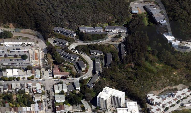
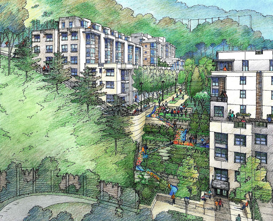
Westlake Urban, which purchased the 86-unit Kirkham Heights apartment complex at 1530-1585 5th Avenue back in 1976, is pushing forward with plans to level the existing 11-building complex and build up to 445 units across the 6-acre site, with six new buildings rising up to 40 feet in slope-measured height at the base of Mount Sutro.
In addition to 86 new rent-controlled units to replace the existing 86 rent-controlled units to be razed, 13.5 percent of the net new units would be provided at below market rates as the project’s Environmental Evaluation Application was filed prior to the passage of Proposition C last year.
And speaking of the Environmental Evaluation, the Environmental Impact Report (EIR) for the project is about to be prepared, the notice for which is slated to be published tomorrow and the formal scoping meeting for which has been scheduled for the end of the month (March 30).
The Kirkham Project would be the largest residential development in the history of the Inner Sunset.
And in addition to the 445 apartments, the plans for the project as designed by Van Meter Williams Pollack includes off-street parking for 252 cars and 445 bikes, with a series of terraces, paths and steps connecting the development to the Mount Sutro trail network above and the neighborhood below.
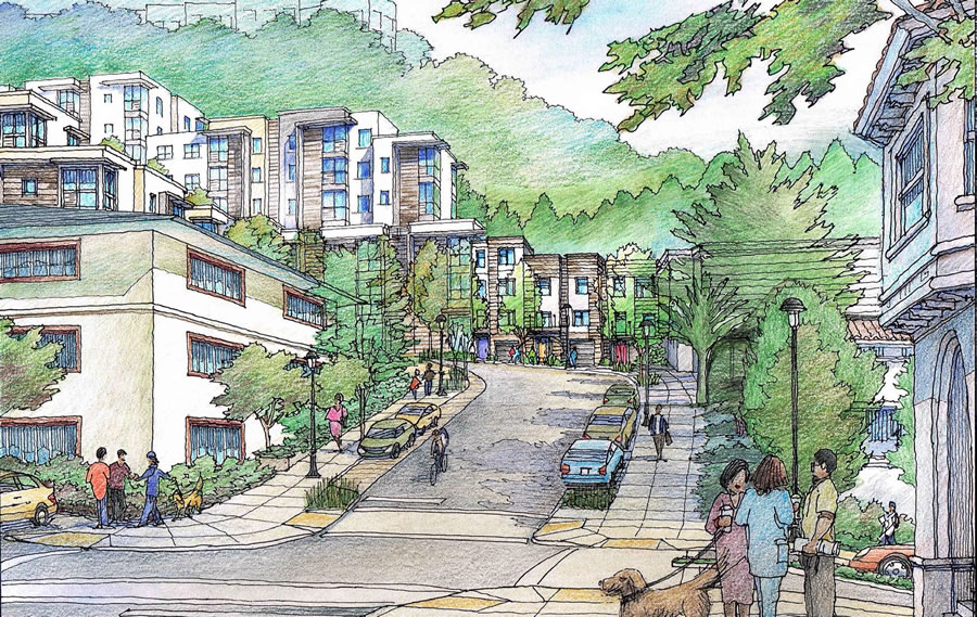
These renderings never cease to amaze me…people always strolling about, hanging out on their balconies checking all the action happening below.
Not enough children with balloons.
And puppies, where are the puppies?
And the encampments, where are the encampments?
The paucity of helium balloons and the absence of puppies are related phenomena.
It does seem impossible. Where are they going? What are they doing besides walking around? If there were some shops in the plans/renderings it would be more believable.
maybe someone set off a fire alarm?
Yeah just the same as in Communist Russia or Vietnam. What’s the big problem? That’s the new direction the country has headed. You have to take responsibility and not buy that new iPhone but peek out of your balcony you know! That’s just being smart!
The renderings are intended to show how the proposed structures might be used by residents and guests and how they could interact with the buildings. It is not meant to capture a specific hypothetical moment in the day of the planned development.
Generally, if a building has trails connections and walkways, people will use them. The same goes for balconies. No one is saying all the residents will always be on the trails or looking over their balconies, but some will do so at various points in time.
I am not sure why everyone here wants to take things so literally? I guess people just like to b**** when they post on the internet.
Is there a modeling agency that hires people to pose for those renderings? Seems like a pretty good gig.
Show of hands: Who has ever seen anyone out on a balcony enjoying a morning cup of coffee?
I do it all the time, starting this time of year. My balcony looks east and I get to watch the sun rising over the bay. I go out in a sweatshirt and a cup of coffee and read the NYT. It’s lovely.
What Happens to the multitude of current residents?
Maybe that’s who all those people milling about are…
Replacement units are proposed.
Otherwise, they can just move to Texas, like most rational working class people do?
The current 86 rent controlled units are being replaced one-for-one (and new affordable units are being built). Also, if the developer has to move the current residents out while the project is under construction, then the developer will have to assist them with finding replacement housing. That said, the proposal may involve a phased-demolition of the existing buildings, so that they are gradually replaced with new buildings and current residents can be moved into the new units.
How many parking spaces will be allocated to the 86 rent controlled units? If they only build around .5 spaces per unit, then those spaces will become very valuable. This neighborhood has about one car per employed person and over 80% of rented units have at least one car. Gonna be fun lugging your stuff up that hill from your residential parking zone J space on Locksley Ave. Or will this development be excluded…
BTW, the current marketing for the rent controlled Kirkham Heights Apts includes : “Easy access to highways 101, 280, 1 and 80. Short drive to downtown San Francisco, Sausalito, Berkeley and SF International Airport.”
Mark: I always assume the rendering is showing what people would be doing 10 minutes after a medium sized earthquake. As a bonus, it shows the buildings were not damaged.
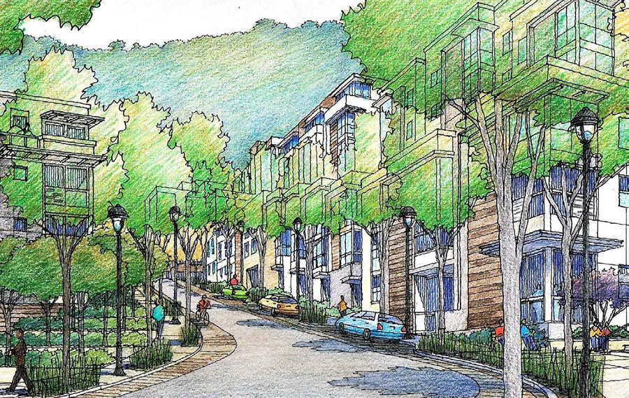
On a development like this, it would be instructive to know how much street parking is included. I’m guessing that the parking ratio exceeds 1:1 with that addition. If that is the case, I’m not concerned about the parking ratio. However, although I’m in general totally in favor of providing way less than 1:1, you’ve got to be honest that this is NOT an ideal location for car-free life and the totality of parking availability needs to recognize that.
As designed, the proposed project would yield a total of 12 on-street parking spaces within the development, for an overall parking ratio of roughly .6 spaces per residential unit, positioned to adhere to San Francisco’s “Transit First” policy.
that’s strange…you can see virtually all of them in the renderings then. From the aerial it looked like there would be a lot more street frontage. I’m going to bet that the final project will have a higher parking ratio.
Keep in mind that all of the parking in the very first rendering above already exists and is actually outside the project area.
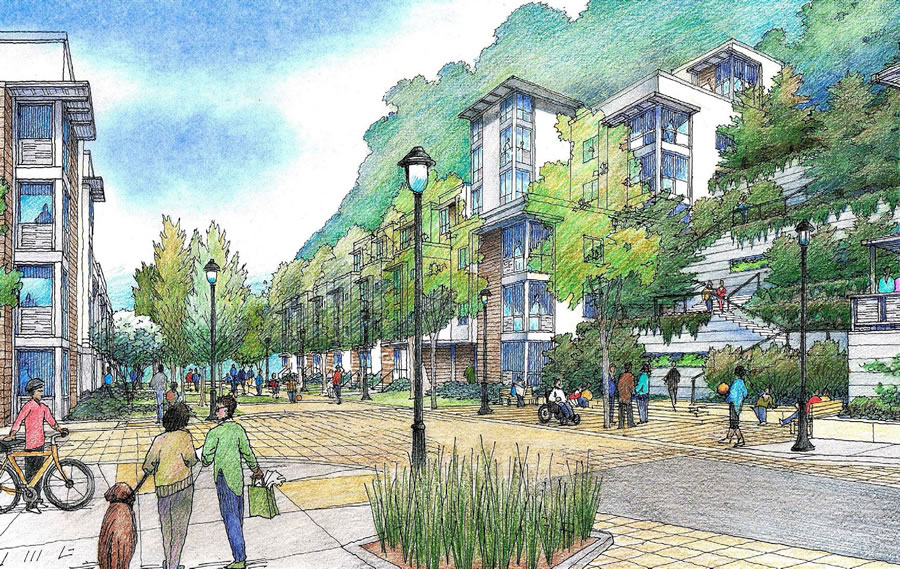
In addition, the proposed site plan reduces the street frontage accessible by car, with a large community terrace to the north, as rendered above, and a slightly smaller garden terrace to the south.
It’s about a 10 minute walk to the N-Judah, so better than most of western SF.
My friend take bus to Forest Hill and then metro to download in less than 25 minutes. N-Judah from 19th takes me 30 minutes or more on a good day. Lately it is breaking down on a daily basis though.
It’s about a 10 minute walk – up a steep hill on the return (with groceries, etc.), to the N-Judah – a train that is already always SRO at this location during rush hour.
FTFY
Don’t understand how the renderings can show so many people walking around when there are no shops or other commercial spaces to walk to, or cafes to hang around in. Cognitive dissonance. It would be more realistic if all the foot traffic was in a line going one of two directions, to Irving. and back from Irving.
A small corner store or cafe would do wonders for the project.
I really wish that were provided in more projects.
There might be a small bit of retail space that could be incorporated, but frankly all the residents can just walk to a few blocks to all the commercial establishments on Irving, Judah, 7th and 9th Avenue, etc (or take the bus if they are elderly or have a disability).
We already have enough EMPTY neighborhood commercial spaces in the city, and we need to stop insisting that every single residential building have commercial space beneath it. Even in very dense cities like New York, thousands of residential buildings are all-residential, not everyone lives above a restaurant, store, or bar (or wants to).
Tellingly, even on SS, most of the comments involve sniping about parking and aesthetics, and nobody cheering the fact that where once there were only 86 units there will now be over 5 times that many in a city with a crisis level of housing shortage, without the loss of any rent-controlled units – PLUS the City gets an additional 49 BMR units out of it, without any City subsidy. All of it on the West side, the part of the City that has not done nearly enough to shoulder its share of the City’s housing production needs.
Well people are generally wired to complain / critique rather than cheer. But yeah, it’s definitely a good development—let’s get it built!
I’ll cheer. It’s good looking and very urbane. I’m doubtful about the parking…but more power to them if they can get away with it.
I’m not reading that anyone is against the project. Questions/comments about the parking situation and aesthetics are valid.
What is “slope-measured height”? Wikipedia doesn’t know so neither do I.
Is it height measured from the lowest, highest, average, median height of the bare dirt?
Technically speaking, and with plenty of nuances, the following rules apply when measuring building heights on a slope, “the point above which such measurements shall be taken shall be as specified as follows:
(A) In the case of either (B) or (C) below, such point shall be taken at the centerline of the building or, where the building steps laterally in relation to a street that is the basis for height measurement, separate points shall be taken at the centerline of each building step.
(B) Where the lot is level with or slopes downward from a street at the centerline of the building or building step, such point shall be taken at curb level on such a street. This point shall be used for height measurement only for a lot depth not extending beyond a line 100 feet from and parallel to such street, or beyond a line equidistant between such street and the street on the opposite side of the block, whichever depth is greater. Measurement of height for any portion of the lot extending beyond such line shall be considered in relation to the opposite (lower) end of the lot, and that portion shall be considered an upward sloping lot in accordance with Subsection (C) below, whether or not the lot also has frontage on a lower street.
(C) Where the lot slopes upward from a street at the centerline of the building or building step, such point shall be taken at curb level for purposes of measuring the height of the closest part of the building within 10 feet of the property line of such street; at every other cross-section of the building, at right angles to the centerline of the building or building step, such point shall be taken as the average of the ground elevations at either side of the building or building step at that cross-section. The ground elevations used shall be either existing elevations or the elevations resulting from new grading operations encompassing an entire block. Elevations beneath the building shall be taken by projecting a straight line between ground elevations at the exterior walls at either side of the entire building in the same plane.
(D) Where the lot has frontage on two or more streets, the owner may choose the street or streets from which the measurement of height is to be taken, within the scope of the rules stated above. Where the height limits for buildings and structures are established by this Code, the upper points to be taken for measurement of height shall be as prescribed in the provisions relating to such height limits.”
Thanks. I made four guesses and they were all wrong!
That description reads like it is quite San Francisco specific. So the short answer is that height is referenced relative to the curb in the center of the building’s street address.
A corollary is that on a street where the slope runs perpendicular, buildings on either side of the street will effectively be allowed the same absolute height. But buildings on the downslope have a larger effective buildable volume since floors might be built below the street. They also have the better views 🙂
This clause is interesting:
… in other words if the parcel abuts multiple streets and you can declare an address on more than one street, choose the highest street.
Between the 445 units added here and the 149 units proposed at the church site at 250 Laguna Honda near Clarendon Ave, a lot more cars will be added to the already crowded 7th Ave/ Laguna Honda/ O’Shaughnessy corridor to the 280 and 101 freeways.
even though these projects are quite large, that really does next to nothing to the performance of the street. Everyone doesn’t come and go at the same time. Traffic is not a valid reason to oppose a project in an urban area (although everyone jumps on it).
The 45K of Lyft and Uber cars that are out in force every day are awaiting the challenge.
Also, of those that have to drive down 101, few will choose to live here. Many might switch to N + BART / Caltrain. Worth a study.
This location is also pretty good for cycling. Shouldn’t be too difficult to reach the wiggle from there.
I see this as being an excellent location for young professionals who don’t drive.
My bet would be that many of the people who live there will end up walking to and from their jobs at the UCSF Parnassus campus next door, much like the current residents (we used to live on 5th Avenue and met many of them en route or at the day care center on Kirkham–they joked that there should be zip lines to each location from the complex.) Between that and the short walk to the N I suspect that parking for cars is not going to be a big deal.
yes, this will be very attractive for UCSF employees. There are UC shuttles from Parnassus to the other UCSF sites, so it would probably be feasible for someone who works at Mission Bay, SF General, or elsewhere to live here and commute without a car.
The proposed project is a condo development on steroids, built on a former quarry site and and official landslide hazard slope.
As proposed it will pave nearly 100% of the 4.12 developable acres, wiping out nearly all the open space and tree canopy which exists among the existing eleven buildings that you can see in the aerial shot at the top of this document. You might check out the drawing of the proposed development on the Westlake Urban website.
The claim of 40 foot height is bogus. The buildings rise to 8 stories if you look at the proposed drawing, and count as ordinary people would count observing the development. The location of different entry points to the buildings allows the “new math” calculations. The project will add 1,000 people to the area, without sufficient infrastructure.
But, seriously, the new project will reap about $20,000,000/year to Westlake Urban while providing virtually no genuinely affordable housing to San Francisco’s current population. The project will not provide needed housing. It will provide market rate housing.
The developer estimates that about only 30 tenants will return to new “rent controlled replacement” apartments. The other 56 “replacement units” will begin at market rate rents, already beyond the means of the vast majority of local residents. Of the remaining 359 new units, 310 will always be market rate, unaffordable to all but the new folks arriving with high 6-figure salaries. Even the Below Market Rate units will be unaffordable to all but a few.
But the owner of Westlake Urban will be one happy camper. And the project will increase gentrification of the area, and motivate increases in commercial rents and residential rents, thus gradually increasing displacement of existing small businesses and residents. The project is being sold as “green” but it wipes out all existing green, in order to build 445 units. It falsely claims it will connect to the steep trails on Mount Sutro. The leader of Sutro Stewards says that can’t be done. It offers landscaped stairways.
An alternatively designed project designed to fit the site, instead of the plan to excavate up to a 60 foot high football field of rock and soil from the site to fit the demands for huge profits would be preferable for the Inner Sunset, and the City. An alternative project designed to fit the slope, double the housing, and provide a minimum of 30 – 40 % truly affordable units for working and middle class folks would actually dent the City’s extravagantly priced housing.
But SF’s administration and the State are not promoting deep affordability to truly meet the housing needs of local working and middle class folks. Too bad. This proposed project serves the needs of a developer, but not the needs of the majority of San Franciscans and their families or the needs of the local community.
good analyses — thank you Denis M.
When you surveyed the 310 households who will be able to afford the new market rate units, were they happy about finding a place to live in San Francisco? Or are they just the wrong kind of people?
Who is going to build these affordable middle class units, given endless NIMBY battles, land costs and permit fees? I suggest you sell your Westside house for $100,000 to do your part in truly solving the crisis? Because, after all, if the evil developer (sons of Satan* all) is being asked to forego all profits, why should the existing NIMBYs not be expected to do the same?
*Of course, your home was built by a virtuous multiethnic pioneer who constructed the structure by himself with recyclable green materials. No “developer” was ever involved in raping the landscape where you live in developing your existing neighborhood.
You and your neighbors could always step in and donate a housing unit to someone from the local working and middle class if you feel this strongly about affordability. It’s not that different from asking the state to do it.
The building heights are what they are. Building height is measured from the slope. Yes, we can also see the buildings will have 8 levels, but that is not how you measure building heights on sloping land. If you disagree with how height is measured, then push to change the law.
As for the affordable unit percentage, Proposition C does not apply because of the when the application was submitted for this project. Again, if you dislike it, then push to change the law.
I think the project is a good adaptive reuse of an under-built site, which will be a good fit for the area and bring much needed housing.
At the end of the day, if the project meets most of the current zoning, then it is likely to get approved.
I live a couple of blocks away from the proposed development.
Personally I think this is not bad at all. Mostly it makes more efficient use of a bunch of space that is already used for housing. As far as I’m concerned, more density is good, and more people in our neighborhood means more restaurants, more street life – more of what I live in a city for in the first place. The mix of rent-controlled and market-rate units is good. The demand for these kinds of units near UCSF is high. My only concern, as raised above, would be around parking and traffic.
Is this a better project than some other theoretical place to put density? Maybe not. Personally I think we should upzone to 6-8 stories along Lincoln, for example, where there’s good transit and the park. But those theoretical other projects don’t exist. We need more density in this city, and this is a thoughtful design to increase density within an existing development zone.
No objections from this local.
That small building on it’s own that you see in the near right hand corner of the photo is a 2 unit condo – the lower unit came on the market a couple of years ago and I remember seeing it and wondering how this project would impact it. I don’t think it ever sold.
I live in Kirkham Heights. My wife and I raised our children there. Although our unit is small, having a backyard that we shared with the other tenants in our building made it “family friendly.” The kids played back there all the time, within eyesight of the kitchen window. Tricycles, street chalk, ball games, and barbecues were favored backyard activities. We even have a small garden.
The Kirkham Project proposes to replace this with common spaces – the “Community Terrace” and the “Elderberry Garden” that will be shared by all tenants. There will be no privacy. These gardens also happen to be emergency vehicle access roads per the project plan. If the gardens are built as described in the plan’s Conditional Use Application, they will break several fire code regulations:
1) Fire access roads must have an acceptable surface capable of supporting 75,000 lb. fire trucks. I don’t think soil covered with plants is what they have in mind.
2) Fire access roads must have clearance from trees. The regulations are particular about clearance specifications. The diagrams show lovely trees between the garden “roads” and the buildings. The trees are clearly non-conforming with code.
3) Fire access roads that exceed 150’ in length must have a turn-around. The project plan marks the 150’ foot boundary as the limit, but the garden roads extend further. An ambulance entering one of these gardens followed by another emergency vehicle would be stuck.
4) The gardens are the only areas that are designated for aerial fire operations, but are only 20’ wide.
So, it seems inevitable that the final version of the Kirkham Project replaces the gardens with pure hardscape. This is what happened in another recent redevelopment (the Alchemy project located at the old UCSF Extension site). Their “gardens” turned into hardscape when finally built. This means that the only open space with even a touch of green will be stairs (I’m astounded they can get away will classifying stairs as open space) and the roof tops that will be available to penthouse dwellers.
Another major fire consideration is that there is one access road, and all traffic must pass through the 5th and Kirkham intersection. If you examine Appendix “D” of the California State Fire code you will see a regulation that residential developments with more than 200 units are required to have at least two access roads, whether or not the buildings have sprinkler systems. Here in San Francisco this decision is up to the discretion of the Fire Chief.
The plan will reconfigure 5th Avenue so it follows a grid pattern. The road will be shorter than its current winding configuration, and therefore, on average, steeper. The new configuration is steep enough that an exception to the fire code must be granted. The existing configuration has a very steep hairpin turn that will be eliminated. The new configuration will reduce the road width from its current minimum of 33’ to 26’. The existing turnaround at the top of 5th Avenue will be eliminated in favor of “Hammer head” turn-arounds.
Overlaying multiple fire code violations and reducing vehicle access scares me, frankly.
The Planning Department encouraged reconfiguring the road to a grid. In almost all of SF a grid makes sense to facilitate traffic at intersections. On a dead-end street, favoring a grid-like pattern seems like mindless conformity for its own sake. Sadly, SF seems to have arrived at a point where even slightly eccentric streets are unwelcome.
Another bad thing about the street reconfiguration: There are only two designated loading zones. Since half the units won’t have parking spaces this means there will be a large dependency on deliveries. Suppose 200 units of the 445 depend on grocery deliveries. Refrigerated or frozen food means you must be at home to receive delivery. Further assume that most people work during the day. This means that the loading zones won’t be able to handle the demand for the prime 6:00 pm to 8:00 pm grocery delivery time window. It doesn’t take much imagination to see this will be a mess. Also the loading zones will be as far as 100 yards from some of the units, and there will be no grocery cart available for the last leg of the delivery.
And by the way, grocery delivery trucks, UPS trucks and FedEx trucks are all too large to U-turn on a 26’ road. I checked. They will have to use those hammer head turns that will inevitably be illegally parked up – and are the entrances to those gardens.
Assume with 445 rental units that about 100 units turn over per year – an average stay of a little over four years seems about right. This means that at the end of each month we can expect 8 move-outs and move-ins. The prospects for those two loading zones are getting dimmer and dimmer.
Now let me tell you what I’m really worried about.
My family and I were evacuated from Kirkham Heights in February 1998 due to a landslide that occurred on the property. Rock and mud cascaded down to Kirkham Street, hitting the UCSF Building MR-4 (since demolished) on the opposite side of Kirkham, burying several cars in the UCSF parking lot, and rolling down Kirkham Street. We weren’t sure if the building would survive. It did, minus its side yard and fortunately we were allowed to return. The City placed concrete barriers at the corner of 5th and Kirkham to keep the intersection clear. The mud continued to roll down the street each time it rained. The landlord covered the hillside in burlap as a temporary protective measure.
Finally the rain stopped, things dried out and returned to normal. Kirkham Heights put in a retaining wall. It’s not an ordinary wall. Holes were drilled into the side of the mountain, steel cable inserted and then concrete was poured into the holes. The aluminum caps over the holes and the concrete beneath them are easily visible today. This is one of two active landslides on the property.
Behind 1580 5th Avenue is a 20’ high steel bin wall. This portion of the property is adjacent to Crestmont Overlook. The Crestmont Overlook EIR from a couple of years ago has a geologic map that labels the area behind the bin wall with one word – “Landslide.” The SF Public Library in its on-line photo archives has a picture of the landslide that occurred there in 1958. The notation with the picture says that residents were evacuated during that landslide as well.
UCSF did a landslide risk assessment of their Parnassus Heights property in 2005 using airborne LIDAR and computer simulation. Since UCSF owns property on three sides of the Kirkham Heights parcel, Kirkham Heights was included in the UCSF study. The results are given in terms of probability under different scenarios, the worst being “wet, seismic” conditions. Under that worst case, the study concludes the probability of landslide on the proposed redevelopment portion is between 75 and 100%.
The Kirkham Project proposes to remove both walls and excavate directly into two active landslides and this entire high-risk area. The U.S. Geological Survey studies risk factors for landslides. Excavation in areas of prior landslides is right at the top of their list.
And not just a little bit of excavation, mind you – over 60,000 cubic yards. Enough to cover a football field, including the end zones, with a layer of dirt and rock that’s 40’ high. The route that the trucks will take has not been disclosed.
It’s not clear whether a landfill site in California will accept the excavated material, or whether there is too much toxic residue for California to tolerate. This is an open question because of the site’s history. It was an illegal quarry in the 1940’s. It is unknown whether explosives were used, but historical accounts of quarrying indicate that using dynamite was common practice. Later, the Kirkham Company contracted with the Department of Defense for a sewer easement from the Nike missile installation on Mt. Sutro. This arrangement lasted for about 20 years starting in 1952 until the missile silo was decommissioned. It is unknown whether the military put any toxic waste through the sewer that runs through Kirkham Heights. We do know that there are instances when the U.S. military has been less than fastidious about its waste disposal habits. The sewer that was used still exists on the property. Finally, the current management has used Roundup from Monsanto Corp., a known cancer causing substance, as an herbicide on the property.
There’s much more, but I’ve already said enough.
I support redevelopment of the property, but not this project. I can envision a plan that doubles existing density without the risks associated with this plan. Conforming to current parking restrictions, eliminating the space inefficient driveways and carports could get us most of the way there with much lower impacts.
Thank you Roger. A very good analyses of the project all of which should be addressed in a full EIR.
My own 2 cents is that the amount of rock to be removed may have “haz levels” of naturally occurring lead and other heavy metals requiring special handling, trucks and disposal options, all of which carry their h=won costs and risks.
The California state rock is serpentine which is loaded with chyrsotile asbestos.
I have always wondered how it works when developers want to knock down an apartment complex? What are tenants rights and/or how do you organize among multiple owners in the same building? Anyone know?
My first reaction is I don’t like it. The current buildings are dated and could be redeveloped but what is proposed here is ridiculous.
Take the recent build out in Brotherhood Way (I think it’s called Summit). That development was taken way too far and ruined the park like surroundings and sticks out like a sore thumb. Not to mention the streets were made too narrow, as a result no sunlight ever reaches street level and most of the homes are in perpetual shade.
This could be another disaster like Brotherhood Way became. In short, this needs to be scaled way back to fit this location. The sad thing is the 400+ unites being salivated over could be thrown up in another part of the city that can support the added population. As currently proposed, it seems out of place.
UPDATE: Timing for Massive Inner Sunset Development Revealed