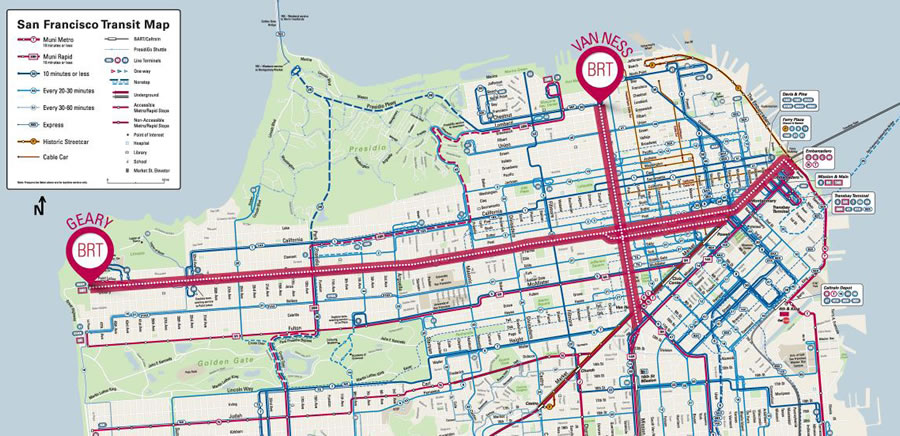
With construction of the Van Ness Bus Rapid Transit (BRT) project underway, the proposed Geary Corridor BRT line is now one big step closer to reality with the San Francisco County Transportation Authority Board having certified the project’s final Environmental Impact Report (EIR) last night.
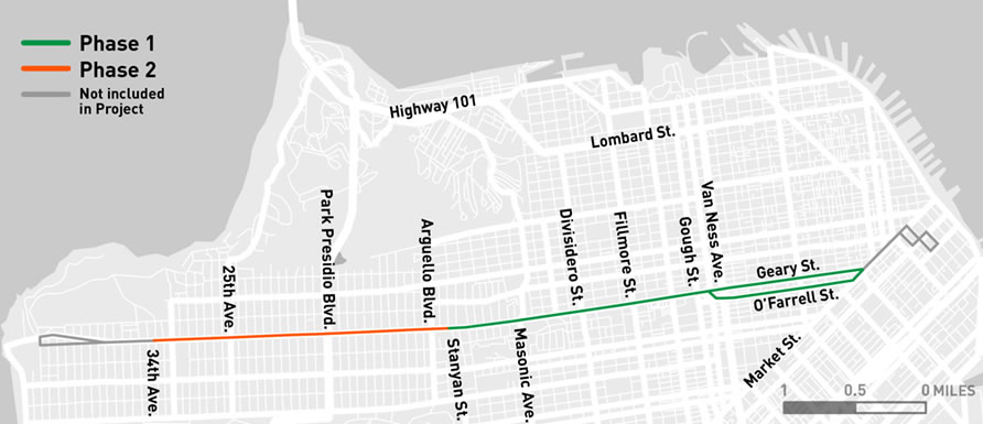
In the works for over a decade and contested by merchants and neighborhood groups along the 5 mile corridor, if the proposed Geary BRT plan is adopted by the San Francisco Municipal Transportation Agency Board, which is expected to happen by July, implementation of the $300 Million project, which would eventually stretch from Market to 33rd Avenue, could get underway this fall.
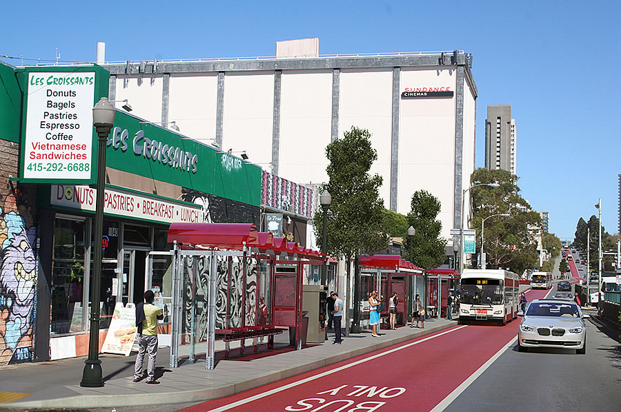
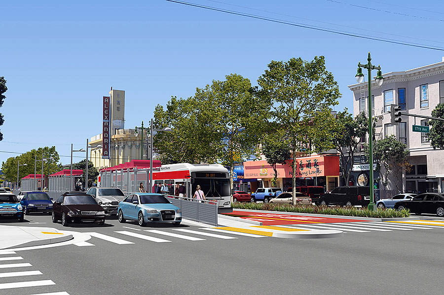
In addition to a whole host of streetscape upgrades – including new landscaping, lighting, and sidewalk improvements – the BRT line could shave up to 10 minutes from a future cross-town trip, a projected 24 percent improvement.
Construction on the meatier second phase of the Geary BRT project, which includes dedicated center-running lanes and consolidated stops from around Palm/Jordan to 27th Avenue, isn’t expected to commence until 2019 at the earliest.
Keep in mind that based on over 2,600 responses to the City’s solicitation for ‘visions’ as to where the next subway lines and connectors should be constructed in San Francisco, a subway line down the length of Geary Boulevard dominated the results.
And in fact, a light rail line, which was the first publicly-operated transit line in the United States, once served the Geary Corridor, opening in 1912 and eventually running from downtown to the beach. The rails were removed and the corridor was converted to bus service circa 1956.
When was this project launched? At least ten years ago. More? I’ve been hearing about it just about forever.
Fifteen years and $300M to get a red stripe painted down Geary – your city government at work.
That’s exactly what I was thinking. Maybe Trump can get Mexico to pay for it?
especially since we shield all of the illegal immigrants, even if they committ multiple felonies
The irony of this comment is that Mexico City implemented one of the world’s most successful BRTs. So yeah, lets bring the Mexicans here to build Geary BRT. They have proven they know how.
San Francisco. Where we don’t want to do anything that might upset anyone ever.
A city of cowards.
Let’s not get carried away.
And to think they used to call this The City that Knows How.
Well said!
BRT is a bit more than a painted red stripe, supposedly the signals will be synchronized and prioritized for buses. And the theory is that you can just plop tracks down in the bus lane eventually. But to me this is not the right direction – geary at least out to japantown really needs to be underground not surface rail, and so doing BRT will in my opinion make it harder to do subway later because the temptation will be to just track the BRT lane.
I think this really depends on the funding environment. If BRT results in increased ridership, I think that would improve the case for a future subway. There seems to be no-way/no-how on the subway plan at least at present (from what I can tell), so the options are really (a) do nothing or (b) BRT.
My personal belief is you take what you can get (even if incremental) and that makes it easier in the future for the bigger upgrade.
Agree with all you said – and frankly even if they were proposing to build a *bus* tunnel from Japantown to ~Market, I’d be supportive – because that would speed bus service through the slowest, most congested bottleneck area. But painting red stripes on the street is all we’re going to see for decades; even if the project’s complete by 2020 (read the fine print about the western “phase 2”), then SFMTA will want to “see how it operates” for several years before admitting failure .. .then another decade plus to “study” a subway, and another decade to build it … In short, this 50-year-old will be in his grave before there’s a subway even partly down Geary.
A bus tunnel that other lines could use like they have in Seattle makes too much sense
totally agree. once we settle for this crap, we will never get real transformative solutions.
Correction: “Bus Rapid Transit [sic]”, not a rapid transit line. Even the SFMTA admits that the red lanes will only shave off a couple minutes from the 38’s cross-town travel time. (While ripping out median plantings and forcing pedestrians to stand in mid-traffic bus stops.)
That’s what they actually said:
“Geary BRT would make bus service 20-24 percent quicker along the corridor, saving people on 38 Geary bus routes up to 20 minutes per round trip. More consistent wait times will mean buses arrive more frequently.”
This translate to up to 10 minutes saving one way.
The increase in reliability is often underappreciated. The bus lanes through the Mission honestly only result in a few minutes of saved time, but since they went down the reliability of the 14 and 49 are undeniably better. When busses actually keep the right frequency you get back a ton of the time you lose taking public transit.
About 2 months ago, I perused the SFMTA website and the materials at the time were discussing a 2 to 3 minute time saving across one-way service. If they’ve changed that, so be it – but as noted below, I *strongly* doubt the accuracy of their predictions.
and no mention here of the significant number of trees that will be killed in this process
Improved public transit can allow thousands more people to live in dense, already-developed areas. The alternative is for them to live in greenfield exurban developments, which (obviously) kill vastly more trees.
My god, there is, apparently, an equivalency for everything.
The city needs more trees. Give me an equivalency that refutes that…
BRT is a joke and hope all the citizens of Richmond continue to fight it. a true subway would be the best
I’ve never seen SFMTA materials claiming a 10 minute improvement – as of a few months ago, the PR materials being distributed in the Richmond were citing a 2 or 3 minute improvement, across the entire route.
If a 10 minute improvement equates to 24% reduction (let’s round to 25% for ease of math), I assume that means a reduction in travel time from 40 minutes to 30. Given that even the 38R (which skips many stops) has 22 stops along its inbound route (not counting starting and end points), if we assume a dwell time of just 20 seconds per stop (conservative), that’s 7.3 minutes tied up at stops, leaving 22.7 minutes for actually traversing the city. (A dwell time of 30 seconds per stops would leave just 19 minutes to actually roll along the route.) I find that to be a ludicrously optimistic estimate; even in one’s own car, travel from 48th Ave to the Transbay Terminal can take that long or longer.
Note the “consolidated stops from around Palm/Jordan to 27th Avenue”. How many stops does the 38R make on that stretch?
Per the SFMTA and SFCTA, the projected travel time savings of the BRT line versus future conditions is “up to 20 minutes round trip.”
Well from Divisadero to First & Market takes about 20 minutes in the morning on the 38R with the regular 38 taking about 5 minutes more. So just knocking out a couple stops can save a lot of time.
it takes me 36 minutes on the express bus from arguello to last stop downtown. their numbers are sh*t
OMFG, just get it done!!!
Clearly, these projects are simply intended to make it more difficult to drive cars in the city. Look at what’s happening on Masonic right now. And Van Ness. And Polk. And Mission.
what’s wrong with that? as the population of the city increases its not sustainable to add more cars into the roads, so people should start taking public transportation..
Gorkem, in the short term you are correct. In the long term not so much. Billions of dollars in transit that takes decades to complete is not the solution and is a legacy way of thinking. Privately funded autonomous transport is the future, at least for the first and last mile(s).
Think 20 years down the road when all cars have a wide array of sensors, plus vehicle to vehicle communications. Accidents will be a thing of the past and cars will be much, much smaller. Vehicles will re-route automatically based on traffic, and will be able to drive inches from one another to reduced unused space on roadways. You’ll be able to summon an autonomous Uber that is sized according to how many passengers and how much luggage are being moved. There is no reason there can’t be, say, 5x as many vehicle trips per day with no increase in congestion.
Sure I am happy with that.. This proposal doesn’t cost that much money, we can spend this amount for short term gains.. In the long term I still believe a good subway system outperforms self diving cars in high density areas where there are lots of pedestrians crossing the street.
So, the small businesses with bricks & mortar should force the people in the burbs that support them to take public transportation? So we’ll have more sm biz death?
Exactly: SF is getting bigger / more populous, so to avoid gridlock we have to get more people moving in smaller spaces = transit, bikes, walking. Pretty simple.
These projects merely worsen gridlock. A real solution would be to spend $Bs on underground transit. Painting red lines over city streets helps nothing.
Agree. And while we are there, nobody should be doing the tedious labor to navigate a car. It should done by autonomous driving or maybe traveling via underground hyperloop network. All these will happen one day. Meanwhile we do the best we can with BRT to move most people fast.
Painting red lines over city streets allows the buses on them– with tens of thousands of passengers– to be exempt from gridlock. That’s the point.
Where would the billions of dollars for a subway come from?
Tax the VC and tech companies. And if they scoff at paying and flee SF, even better.
build it and make the newcomers pay for it, and if they don’t pay enough then default on the bonds. That’s the public privateer partnership favored by Putin’s Puppet, aka PEOTUS.
Carrot vs. stick approach. It’s OK to make driving less attractive if you offer a fast, safe and reliable alternative. But SF and vicinity is lightyears away from that. I evaluate my options on a daily basis and and opt for Muni/BART no more than once a week, trending towards never.
Good. Traffic and congestion are bad things. To alleviate them, you need both the carrot (better transit, bike lanes, etc) and the stick (make it harder and more expensive to drive). And the most bang for the buck – new residential density should be clustered around existing major transit lines.
FYI if you ride in the old muni PCC streetcars on the current F line, you will sometimes see a sticker on the driver dashboard which lists B Geary line. So at least the streetcars are ready! Just need some tracks.
OHHHHHHH muhhh gaaaaawwwwwd…..JUST BUILD A TUNNEL! or elevate it!
Just get it OFF the same elevation as vehicular and pedestrian traffic! Then maybe you’ll have a REAL solution.
It is weird to me that nobody has suggested elevated light rail – seems like 19th ave and geary would be perfect for this. Then raise height limits to ~ 200 feet along the corridor.
Have you ever seen an elevated system that doesn’t look bleak at street level? I’m most familiar with Philadelphia’s Market Frankford line and I would not wish that on any other city. In addition every 20 years or so these systems require heavy maintenance which generally chokes off the streets (and business) below causing major disruption.
Yes. All the modern ones look great. Google Daegu Monorail.
And it costs $1 to ride. You’re killing me.
But this is Ess Eff. How about an elevated cable car ala AirBART.
the elevated in chicago looks very nice IMHO. An undground to Masonic with an elevated from masonic to parkpresidio and an elevated from all the way down 19th to COLMA BART would be amazing.
It would be way cheaper, faster and more fun if we used ziplines instead of buses. Seriously.
People, where is the money going to come from, especially if you want to do an underground system? My god, the relatively short subway line from approx 4th and Market or so to Chinatown was over a billion dollars and that is not online yet. I totally can see on the surface like the lines that go through the Sunset, but not underground. Just. Too. Expensive.
We need to emulate other countries and reduce the cost of transit construction.
This – tunneling a subway west of Masonic would be literally tunneling through sand – something they could have done easily with shovels and mules 100 years ago, let alone with modern tech. It’s ludicrous how expensive infrastructure projects have become.
In the old days we had shovels, mules, and hard working clever guys. Now we have tunneling machines, lasers, and greedy lazy fools.
Well, that’s pretty vague. What is it about other countries’ methods that makes it cheaper?
One thing we could do that’s simple and doable is to use the land used for construction for more profitable purposes. This is true for the central subway-see the Chinatown stop, for example, which is currently being turned into a large, one story entrance when it could be a lot more. It’s especially true for Bart, though, which is sitting on a ton of underused, well-located land around its stations. This has multiple benefits: not only the immediate income from rent, but also the service becomes more valuable when it connects these new locations. It even decreases maintenance and policing costs, since the transit system would only have to be responsible for a much smaller station area.
I wonder if the travel time savings are for the [R]apid bus, or for the regular local bus. Most commuters don’t bother with the local buses anyways, because they make every stop and it takes forever.
The R bus is already pretty fast, but if it suddenly has to share a land with regular local buses making all stops, that would actually increase travel times for a lot of people. Has this issue been brought up at all yet?
this is a collosal waste of money that will add way more problems than solving. maybe 10 minute shave off a trip from ocean beach to davis st, if you are not counting the stop times. From arguello, to downtown, the savings is expected to be 3 mins. That is uttely insane for $300M pricetag. And it will increase congestion in cars so much more by cutting down to 2 lanes (and often 1 due to uber). Pollution will increase, and traffic will be much slower. this is an idiotic plan that may have made snese 20 years ago. geary needs a subway, and this $300M could be a downpayment for truly transformative project
It also removes all left turns on Geary.
There was a city plan in the 1950s that created arterial roads, and the current planning pushes all traffic off of them onto residential streets. This will push all the Geary traffic onto Balboa, California, Euclid, Clement, and a lot more of it, because it will create tons of circular navigation, traveling three blocks to make up for a lost left turn…
TBH, this seems like at least part of the purpose. It downgrades the experience of driving because it satisfies a moralistic impulse, and makes a terrible transit system appear relatively better … and the businesses that die on outer Geary can be upzoned and developed into higher rise residential, which satisfies the developer interests that pull all the strings in city governance.
You nailed it. This is going to be a complete disaster.
What’s going to happen is that Waze and other navigation sytems are going to re-route vehicles from Geary to residential streets that never had much traffic. It will make life worse for pedestrians, cyclists and automobile drivers alike. There should be dedicated corridors for each type of transportation.
Maya, some left turns off Geary are being eliminated but many are being kept.
Agreed it’s idiotic; city leaders still think it’s 1980 (fear of height, density, speed).
Rezone all of Geary and create an aggressive blueprint for the next 50 years. increased height density bonus for developers as partial funding for undergrounding.
The added benefit of having 100k new homes not bad. (How ’bout 50% middle income housing for families?)
There is no vision and no real investment in this City’s infrastructure.
Even redoing Market Street has become an annual ‘prototyping’ festival. Sheesh.
This town is all about process and it cannot realize its greatest potential as an academic exercise.
Have no interest in competing with LA but they are undergrounding for the next gen.
Considering what LA county passed tax wise this past November for transportation is mind boggling. What got passed for BART to just do sate of good repairs and Santa Clara transportation to extend BART through San Jose this November is chump chain for what is going on done south. Go a little bit farther south and San Diego acted more like Contra Costa County.
San Fran is not in the league of any of this because Lee can’t even move Caltrains forward to the oversized, expensive Transbay bus shed. In the meantime another fixed transit bay crossing is a pipe dream while it is literally taking years to restripe a third lane that once existed on the San Rafael Richmond bridge. I would put blame on California but LA’s actions and progress blows that excuse out of the water.
Good points. Despite what SF likes to think, it is not in the league of LA or even Seattle.
Blame in this case can’t be put on California – though it has issues compared to other states. Texas is moving forward with HSR that will be privately funded. Between Dallas and Houston. How that turns out I have no idea – but I bet the chances of seeing a completed HSR in Texas are better than in California..
Forget Caltrans. SF can’t maintain the roads as it is. Ride around Lake Merced or down Sloat – the potholes and road conditions are atrocious. Cross to Daly City (towards Westlake Shopping Center) and the roads improve immediately after leaving SF proper. The greening going on in that area is great. Trees, shrubs that actually have some color. SF – nada. Trees are being removed and the Sloat median strip is neglected. Cleaned up once a year, dead plants removed with no replacements – you should see the DPW crew it takes to do that.
You get the government you vote for and in SF voters seem not to hold anyone accountable and to continue to approve bond measures which end up being mostly wasted money.
The HSR line in Texas is much shorter than the proposed HSR line in California. The California line has been politicized by SF and SJ politicians as they rerouted the system up the Peninsula and into a trophy downtown SF station. They should have run the line through the Altamont Pass and up the East Bay with a transfer to BART to SF at the Oakland City Center Station. Most if the line could have been above ground instead of tumeling through the expensive and nimby Peninsula r up to a dead end in downtown SF. San Francisco pol are going to make HSR so expensive in CA because of their provincial attitudes where everything has to begin and end in SF.
Oh, another Oakland plug – too late now, that train is gone.
And a dumb Oakland plug at that. He’s suggesting running HSR on new tracks parallel to BART through the East Bay rather than on tracks shared with electrified Caltrain. And why? So Oakland residents can feel like their town matters?
An above ground East Bay route would make much more sense and be much less expensive. A route over the Altamont Pass could be linked to BART at Oakland City Center and then make its way up to Sacramento using the current Amtrak right-of way. Why build HSR up the Peninsula and into a SF culdesac for billions more? The population center of the Bay Area is where the station should be, not spending extra billions to dig up the Peninsula and downtown SF so that San Franciscans can have a trophy station downtown.
No, it doesn’t make sense, but I know it’s pointless to argue with someone who thinks Oakland is the center of the universe. The Peninsula is already “dug up” by this thing called Caltrain which is being renovated anyway and connected to the “trophy station” that is half way built already.
Most importantly, the point of HSR is to shorten the travel time between SF and LA, so it has to go from SF to LA. They could probably save a lot of money by only building it from Burbank to Fremont, but that would be pointless.
HSR via Altamont Pass is a non-starter because it bypasses the Bay Area’s two largest cities.
Why do they waste all that money painting the roadway? Are people too stupid to read signs?
“Are people too stupid to read signs?” … Yes, sadly.
Road surface markings are signage, though some people are sadly unable to recognize this.
I assume you’re the paint salesman.
You illustrate why signs are often offered in multiple forms: some people compound their errors of recognition out of overconfidence in their assumptions.
I’m not saying let’s go kill all the stupid people….I’m just saying let’s remove all the safety signs and let the problem sort itself out like Darwin intended.
300 million to save 10 minutes one way?
Money better spent on tents for the homeless.
…says someone who without a doubt has already bought a tent and pitched outside their own front door for the homeless to move in.
And people here want even more development in the Richmond and Sunset, so we can throw even more hundreds of millions of tax dollars at helping a handful of people get downtown.
BRT is a great idea – but $300 million? Only phase 1 by 2019? That’s a bad joke right. BRT is a great idea because it is much cheaper and faster than light rail to implement- at least it is everywhere else in the world other than SF…. I feel like we have turned into the Byzantine empire….
Unfortunately, its not a joke and until SF voters start turning down city bond issues and completely sweep out the current PTB at City Hall and replace them with a reform group, nothing will change.
By the time phase 1 would be complete, the city would have poured another $750 million down the drain of enabling more of the aforementioned homelessness. Priorities, I guess.
Los Angeles has the right idea by going underground and the developers are building housing in advance of additional subway construction that was recently funded there.
Los Angeles is still a transportation nightmare with the public transit and subway as an afterthought.
No, Los Angeles had a rail transit system over 80 years ago that was far larger and more comprehensive than anything San Francisco had. They even had a subway! I believe I read somewhere that at one time L.A. had the second largest urban mass transit rail system in the country.
why does the north south line stop at market and not extend all the way to daly city through the mission and excelsior?….. most people riding the 14/49 would want it extended…..
It stops at Mission St not Market. Nevertheless, there is a BART line that runs “all the way to daly city through the mission and excelsior”. A BART line, ferXsakes.
move everything under ground. Then you become a real city; not a mound of drifting sand.