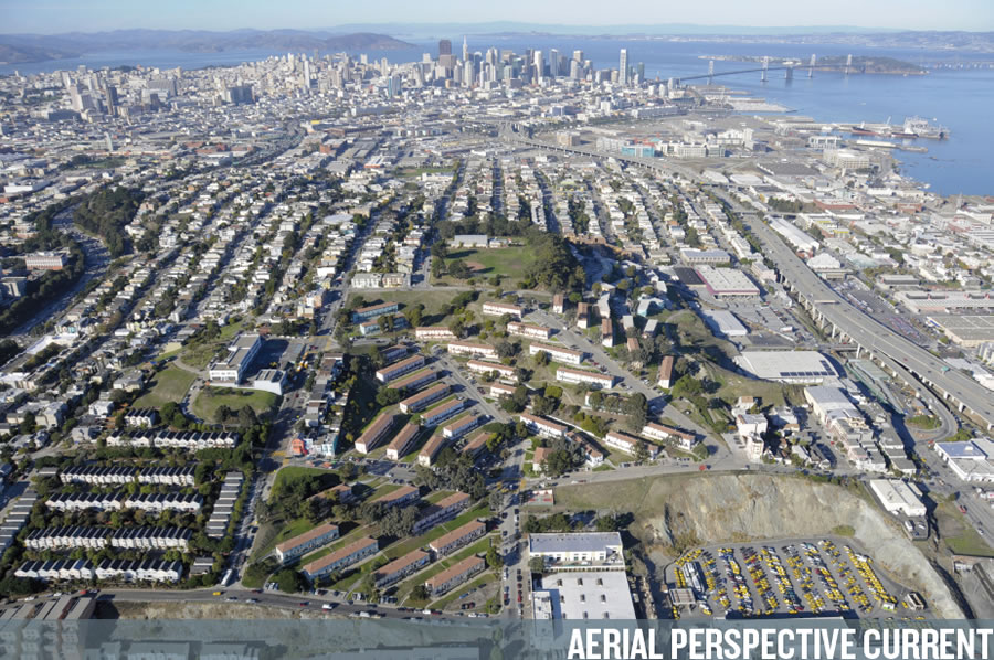
The master plan for redeveloping the entire 33-acre public housing development atop Potrero Hill with up to 1,700 new units of housing has been refined and the first public hearing to help clear the way for the ambitious project to commence has been scheduled for December.
As proposed, the Rebuild Potrero project, part of HOPE SF, would demolish and rebuild all 620 public housing units within the existing Potrero Terrace and Potrero Annex project area while adding 450 new Below Market Rate (BMR) units and 630 market rate units to the community.
In addition, up to 15,000 square feet of ground-floor retail or flex space and a 35,000 square foot Community Center with daycare and preschool facilities would be built along 24th Street between Arkansas and Missouri. Around 3.5 acres of redeveloped public open space, including a new 24th Street Park, are part of the plan as well.
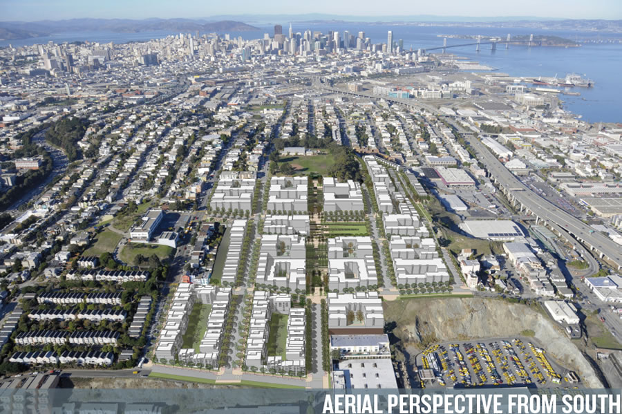
The 600 rebuilt public housing units would remain affordable housing, subsidized by the San Francisco Housing Authority, but would be managed and owned by BRIDGE Housing or related entities.
And if the plan is approved, the redevelopment would occur in three phases, beginning in 2015 and spanning around 10 years in order to minimize disruption to existing residents.
UPDATE: The Future Of Potrero Hill’s South Slope In Living Color.
This will be amazing, hugely and positively transformative. Build it yesterday.
Could they possibly make it more suburban?
Yes, they could. They could do detached single-story ranch homes. This is not midtown Manhattan, its the back side of Potrero Hill, and the density is (1) *entirely* appropriate, and (2) much more than is there now.
We’re building an entire portion of the city from scratch. Why is this more “appropriate” than single story ranches or 12 story buildings. It’s a blank slate, anything can be “appropriate”.
They’re not rebuilding it from scratch, there’s currently 620 public housing units on the property right now. And this is not a major transportation hub, it can’t handle high density unlike other areas in San Francisco. Building high density for the sake of high density is unfeasible.
And with this mediocre level of density it will never support adequate public transportation.
620 units that are being torn down and rebuilt from scratch. I’m not clear on why you saw my statement as wrong. Tearing down the entire thing and rebuilding everything (including the actual street grid!) is absolutely building something from scratch.
1700 units/ 33 acres = 50+ units per acre. More than high enough to support adequate public transportation.
Seems like a good idea to integrate the street pattern into the existing grid. Instead of isolating these buildings and creating a ghetto, it makes them feel like part of the community.
Funny, the one thing I don’t like is the loss of some curvilinear streets… though it’s certainly San Francisco’s way to impose a grid on the landscape, regardless of topography, so at least it matches that historical context.
curvilinear streets are terrible for walking
How so? I like that they vary the view, and give one respite from an awkward sun angle (depending on time of year).
grid system is much more efficient for actually walking somewhere. It is simple to imagine if you think about it and how one gets from point a to b.
curvilinear streets is a suburban invention that offers a bit of exclusivity. Really nobody is walking down the street who is not living there because there would be no purpose
Actually no. If point A and point B are not in a line, then a rectilinear grid forces you to walk longer. Having lived in cities with street grids as diverse as Boston, D.C., and San Francisco, the former two are great to walk in because often there’s a street curving or angling off in some odd direction that winds up saving you time.
Jeff this is city planning 101
A street grid is less efficient for cars and was predates wide use of cars for a reason. Curvilinear streets were an adaptation to cars
Anyway
Not true. Visit Miraloma Park which is one of the most walkable areas in the City. Curvillinear streets add intimacy and reflect the topography instead of paving it over.
Miraloma Park is one of the “most” walkable areas of the City? Um, what? Have you been to any of the neighborhoods in the city with lots of pedestrians?
LOL, have no idea what you are talking about. One of the reasons I did not buy a house in Miraloma park is because you can’t walk.
This is actually city planning 101 but maybe we are talking about two different things. I am talking about access to the city and you might be talking about taking a stroll to take the air and such.
Two words: Harvard Square. Couldn’t be a more screwy street plan, with curves, Y’s, and T-intersections galore – and it’s one of the most walkable, vibrant neighborhoods in the country.
Harvard Square is also an order of magnitude higher density than this absurd plan will be. I’m fine with curvy streets with 40,000 ppsm, this will be lucky to hit 10,000.
Zig, we all can’t be a stone’s throw from Clement or whatever. Some of us have young families and its way worth giving up that for walkability, green space and yes, curvy streets.
That said, being close to the “in” strips does not prevent curvy streets. Check out Seattle or St. Louis.
Dave, you’re still not making sense. Clement is not less walkable than Miraloma Park. Period. Perhaps there are reasons that you prefer Miraloma Park (all valid), but Miraloma Park being “more walkable” than Clement cannot be one of them, because it simply isn’t true.
People are confusing different aspects of “walkability”. A grid is the most efficient system to have access to everything else, regardless of topography. However, a curvilinear system that respects the topography is the easiest walking (or cycling) environment, although you might have to walk or cycle further to get to a particular destination. Because of the grid there are many areas in the City that are difficult to bike for instance…you end up going up and down and up and down very steep grades. I think in most places a grid is preferable in a city, but I recognize that sometimes accommodation to topography isn’t a bad thing.
The ones that have stairways are nice.
yeh and some people prefer curvilinear streets too. The point just being they don’t support pedestrian activity very well
That’s ridiculous. Going straight up a steep hill is terrible for walking. Curvilinear streets are great! The view changes a little with each step, you can keep the incline reasonable for walking, and it keeps drivers from going too fast, and makes them pay more attention to their driving.
They are not good in general for walking though. The first paper I googled in 2 seconds:
“Both increased intersection density and additional street connectivity were generally associated with more walking, biking, and transit use. Street patterns with gridded street networks, which tended to have higher street connectivity than average and much higher street network density, were associated with much more walking and biking. These results suggest that street network patterns are extremely important for encouraging non-automobile modes of travel. As our nation begins to focus on reducing vehicle miles traveled as a strategy to combat carbon production and cut energy use, it is increasingly imperative that we account for this relationship between the built environment and mode choice in our planning and design of the transportation system.”
@Zig Grids are only good for pedestrians because they offer lots of connectivity, i.e. they bisect each other often. Theoretically, curvilinear streets can do the same.
That said, I support the grid for this project. It will hopefully make it feel more like a part of the existing neighborhood.
Your quote refers to connectivity as the important factor. It is easy to make a non-grid netwok as connected, as a gridded network. Please provide a link to the full study.
Curvilinear is boring. Potrero Hill (with the exception of the subject property) is one of the most visually striking neighborhoods anywhere — precisely because of the grid system imposed upon the dramatic topography.
Why oh why are we underbuilding so drastically with this complete rebuild?
wish it was higher and denser along the eastern cliff (above the caltrain station) with much more market rate housing to pay for even more development. an extra 3 stories here wouldn’t steal anyone’s light or views and the proximity to the train and the T line would be prime for commuter living.
the current proposed ratios preserve a project environment. nicer housing for the people unfortunate enough to live there but still poverty warehousing.
the city will never get a handle on housing costs without addressing and benefiting from the market rate side of the equation.
Why not build it bigger!?
^ taller buildings to the southeast of the overall project absolutely would have cast a lot of the other buildings and open spaces in shadow
Yes, so?
So, the point was made that taller buldings wouldn’t take light away. They would.
actually they wouldn’t. they’d be on the steep downslope of the hill looking to the bay. most of the daylight here come from the southern and western light.
5 stories would be no problem, in fact there is a staggered 5 story condo complex below the public housing with great views and walkability to the train…an no impact on uphill light or views.
Agreed – if you can walk to caltrain (and even the T a couple more blocks), 5 stories is better.
Adding shadows is not “taking light away”.
says who? the public space would lose sunlight, clearly
Losing sunlight is not the same thing as “taking light away”.
Sure it is.
No it’s not.
What a waste of space– I guess we are not in a housing crisis after all.
Why does the finished project show the taxi parking lot – aren’t taxis going to be pretty much gone in the next 2 years?
Make it less of a project – extend the street grid and build it to blend in. As someone else mentioned, it’s too suburban.
And, rather than returning people for storage, give them $25,000 each to agree to be stored somewhere cheaper, like Madera, CA.
[Editor’s Note: Yellow Cab Appears To Be Staying Put, Expanding In San Francisco.]
There was a similar scheme proposed for Sunnydale. Whatever happened to that?
[Editor’s Note: Big Plans To Redevelop San Francisco’s Largest Public Housing Site.]
Nice idea but the density should be at least twice what is proposed and with at least 1/2 of the parking as it currently is being done
This is moving in the right direction but I would make it somewhat denser and include more more market rate apartments — mixed communities tend to safe and more vibrant. With respect to SierraJeff’s comments, I am unclear why it is so obvious that lower density is appropriate just because it is on the back of Protero Hill. The development basically links the Mission and the Dogpatch, both of which are slated to have significant amounts of high density buildings. In particular, some higher density units near Caltrain would make sense.
I don’t know how much linkage there can be with the Mission with 101 between them, nor with Dogpatch with 280 between them. With respect to the latter, there could be remediation if the proposed teardown to 16th St. were extended all the way back to Cesar Chavez. Traffic concerns might be addressed by replacing the current structure with a high speed roadway buried tunnel-like as with Presidio Parkway also affording integration of this project with Dogpatch by a “slope” covered with city blocks.
There can be connections between this and the Mission and Dogpatch, though the freeways will prevent true integration; my point was really more focused on why this area is inappropriate for denser development. SierraJeff has not come back and provided his rationale.
Re-integrating the Projects on Potrero’s SE slope with the adjacent street grid will work wonders in making it a less fearful environment – the fact no one but those who live in the housing ever think of going there currently is 40% of the problem (the other 60% is the economics of the City, which we I’m afraid cannot be fix through design).
Actually, the fact that many of the current residents are criminal scum is 100% of the problem. Let’s hope they sleep in the day the bulldozers show up.
The rendering makes it look like the streets are being regraded, with the exception of the street that starr king is on. Is this true? At least currently the steepness of the grade along the west side makes it a fairly difficult bike ride.
As long as the new management supervises the existing tenants better than before this should be an improvement.
I also wonder how market rate housing will sell there vis-a-vis the Shipyard project. Given the housing shortage entry market buyers will probably be motivated, I s’pose.
Market rate housing will sell there just fine. That is just a fabulous property. Glad to see this development finally taking shape.
Miraloma Park is among the most walkable neighborhoods in the City. Stand by my assertion. We moved here because of the non-grid streets. The Sunset was an option then but, yikes, what a depressing area. Block after block of grid streets, virtually no fronts – hate the paved over look. If only – the Sunset could have been special with a little imagination – some directed to stret pattern.
There are those who lament that Burnham’s grand post-1906 plan did not come about. They in part broke from the grid pattern, at least in part.
I am told the original Mission Bay plans called for not just canals but, heaven forefend, some non-grid streets.
Typical this plan – SF settles again for mediocrity. And few seem to care.
You can’t just say you stand by it without anything to back it up. Miraloma Park was developed to be a autocentric suburb within the city mostly after WWII. Transit ridership is much lower than average in that area. It is a very autodependant area and less walkable than the Sunset. Tell us please where you are walking to?
You seen to be confusing your preferences with something objective which is the grid in the Sunset is easier to walk
Miraloma Park is far from walkable simply for the fact that there’s nothing to walk to 🙂 That said, a stroll around there is nice.
There’s a strip mall that has a Mollie Stone, Walgreen’s, Starbucks, Bakery, Bar, Taqueria, Round Table, (crappy) burger joint, CVS and 18 dry cleaning places 10 minutes from my house in Miraloma Park. We take the kids there pretty frequently by foot. I’m also a 4 minute walk from the 36, an 8 minute walk from the 44 and a 10 minute walk from the 43, 48, and 52 (not to mention addl stops for the 44 and 36). It is walkable – I get downtown to work every day via a combo of walking, MUNI, and BART. It’s not downtown, but you can get by without a car.
I agree; I live in Miraloma Park and it is pretty transit-rich and definitely walkable. I prefer it over the monotonous gridiron of the Avenues. Though sometimes you have to walk farther than you would if it was gridded, there are pedestrian-only stair streets and passages that cut through some of the larger blocks.
This plan is certainly an improvement over the mess that exists now. But I agree with those who would prefer more density. The city will never get another chance to remake this area.
Sell that land to developers of market rate housing and build 10x the number of subsidized housing units somewhere else, like Bayshore, near candlestick etc.. Its ridiculous for subsidized housing and projects to use such choice land when living in projects is suppose to be a TEMPORARY situation. Selling that land could build more subsidized housing and pay for it many times over!!!!! Regardless, the density needs to be greater. It;s on the hill so build high-rises since NiMBY views won;t be blocked.
that’s politics for you!
There is merit to what you propose. The particular developmental history of this area of San Francisco aside, I’ve often wondered why this real estate was not more like Russian Hill.
Heck yeah! Use the market rate tax revenue to build and support 20x the number of housing in Modesto. If all it is is warehousing the chronic unemployable, as it is, it doesn’t need to be in a premiere job center
This makes too much sense.
Continue the street grid, sell off each parcel, take 10% of the cost of each parcel and build housing for the unemployable in Modesto or Madera. Relocate them and give them $5000 each to accept the new location.
We should add a requirement for public housing and BMR housing: All the resident needs to hold a job in SF to be eligible. SF can’t afford to subsidize housing for chronically unemployed people.
Also SF can’t afford to provide all the homeless people from all over the country. SF should only take care of homeless people who have worked or lived in SF prior to becoming homeless.
Your logic would seem simple but some of the supervisors we have would find something wrong with it.
Stitching this site back into the Potrero grid is a key improvement here. The other is a mixed residential community. Yes, make it all a little taller too. There are too few opportunities to increase density without opposition. In the rendering the buildings nearer to the OJ Simpson mural community center are at least 4 floors. How about extending that height a little further south?
The current situation is abysmal. It feels like a cross between military barracks and a prison.
Biggest complaints I have on this whole grid approach is:
1) laying an orthogonal grid over steep topography produces steep streets and sidewalks (just like the rest of Potrero Hill!) – Not an improvement; just to “connect to the rest of the nabe”, Also the whole plan ignores ADA requirements for accessibility.
2) the southern edge could benefit from much higher heights w/o impacting the north and could have spectacular views north if high enough.
3) Major lost opportunity for building on solid rock, not bay fill, providing higher density where least objectionable, and a lost opportunity for building new transit connections much needed on Potrero Hill
another problem with the grid. you can take a straight shot with a gun a block or 2 away and hit your target. with a winding street, sinpers cant work as easily
Super lame and insensitive comment.
Insensitive to whom? The current residents of those projects? To the neighbors it resonates quite well, I can tell you that.
But actually, part of the benefit of the grid pattern is that you get through traffic which dilutes the criminal dominance of the streets. Also, it’s easier for cops and emergency vehicles to get in and out safely. You might argue it doesn’t work that well in the Tenderloin but that place is much less of a ghetto than Potrero Terrace.
I read it as not so much insensitive but out of touch. Gangland shootings (which I think Spencer is referring to) aren’t executed with precision long distance sniper shots but instead at close range.
In addition to knitting the neighborhood back into the city, the grid has a number of advantages:
-there are views of the Bay from all E-W streets, which are lost in those parts of the City where the streets follow the topography; the grid is remarkably efficient, equally distributing traffic across the streets; it produces rectangular lots and hence buildings; it is legible to everyone, unlike the curvelinear subdivision.
UPDATE: The Future Of Potrero Hill’s South Slope In Living Color.