With the preparation of the proposed project’s Environmental Impact Report (EIR) now underway, we now have the anticipated timing for the massive 445-unit redevelopment of Kirkham Heights to share.
Assuming the development is approved by the City without any substantial delays, the project team is planning to break ground and demolish the existing structures on the site in early summer of next year (2018). The demolition would be quickly followed by a period of excavation, grading and site prep.
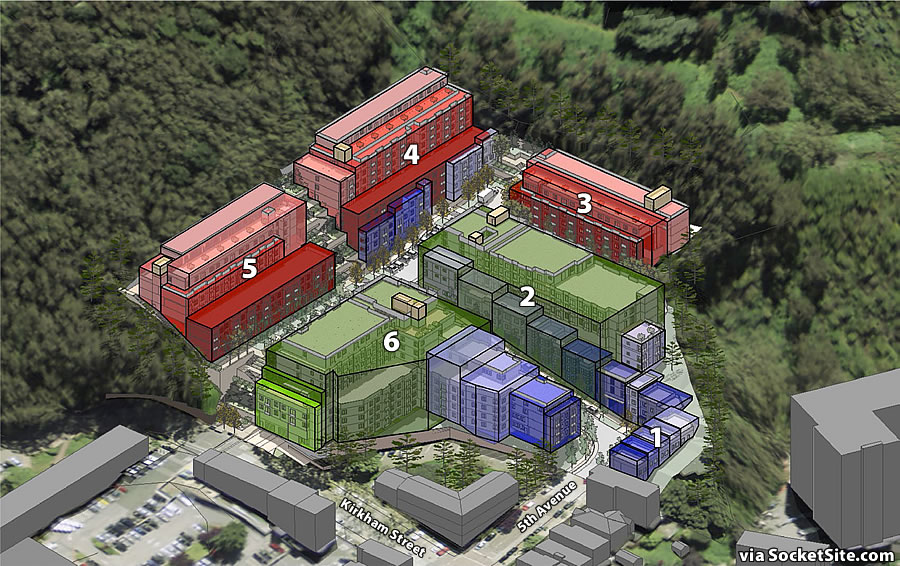
The six new buildings, as massed above and more detailed here, are slated to be constructed in the following order: Building 6, Building 2, Building 1, Building 3, Building 4 and Building 5.
Building 6, which includes 116 of the development’s apartments and 146 of its 252 off-street parking spaces, could be ready for occupancy and opened by spring 2020 with the remainder of the development ready for occupancy in winter 2020/2021.
All current residents of the existing 86-unit Kirkham Heights complex would need to be relocated prior to the Kirkham Project breaking ground but would have the option to return to new rent-controlled units as soon as Building 6 was completed. And the existing tenants would be granted “moving assistance” in both ways, but that doesn’t include securing a place to live during the two to three years of construction.
And with respect to the project’s proposed 252 off-street parking spaces, 30 are to be designated for returning residents.


They should do the same thing to Western Addition, only in phases and provide rental assistance during the build.
Then that dump and utter misuse of land can provide greater housing to both market and below market people while increasing the tax base and making the community prettier.
The irony is that they already did, although the results were less than stellar. Take two?
Right? To start, I imagine that our (SF) intentions would be a bit more ethical and that there would be a far more comprehensive study and subsequent plan in place—compared to 1960-whatever.
Regardless, the 12 square blocks or so between Geary-Fulton + Webster-Franklin are in some serious need of densification and neighborhood ameninity inclusion. Most importantly I’d be curious to hear what the general consensus of the people who live there is.
This rendering makes the project look much more bulky – and out of place – than the prior posting. And bizarre that they’re proposing to build closest to the entrance first – so all the residents in the new building get to enjoy construction vehicles going in and out all the time? (This also underscores and illustrates the comment from u/RogerHoffman on the prior post, about the lack of a 2nd access route – seems like there’s going to be a *lot* of car and delivery vehicle traffic up and down 5th…)
But if you look just next door at Avalon Sunset Towers, the bulk doesn’t seem so out of place.
Bad precedent should not be a model for future behavior. In any event, see how far your analogy gets you if you propose to build another Fontana Tower…
Avalon Sunset Towers are an eyesore reminiscent of Soviet era housing. While the bulk isn’t /too/ bad because they abut Mt. Sutro and that takes the edge off, they are still out of place.
Yep, looks like a big bulky complex in this rendering. Can only imagine how it will look after all the cost cutting and RE.
As for the Western Addition. First, it was a crime against humanity to level the hundred or so blocks back in the 60s. What they got was a dump. Might as well call it a prison. I agree with Joe…level it, start over and give the area the respect it deserves.
Aside from having to move out for two years and having no assistance during that time, getting to move back into a brand new rent controlled apartment with a dedicated parking spot seems like hitting one of the best lotteries this city has to offer.
One of the tenants is an eighty-eight year old retired nurse. She is on a fixed income and has no family left. She does not feel like she’s hit the lottery. Another tenant is disabled and would agree.
Planning Commission staff comes with such academic backgrounds as engineering, architecture or public policy. Yet they are empowered to assess whether or not the tenant relocation plan imposes health risks on certain tenants, a judgement call that is far from their area of expertise.
“One of the tenants is an eighty-eight year old retired nurse. She is on a fixed income…”
Okay? Maybe it would have been wise for her to purchase a residence of some kind 30 years ago, when it wasn’t that expensive, and then nobody would ever be able to ask her to move, even for a little while. She chose to rent an apartment for lord knows how long, and with that come certain tradeoffs. Without some kind of allowance for a plan like this, nobody could ever replace rental housing, and the buildings would collapse into dust because you’ll never have a moment when ALL the various sympathetic old ladies have moved out of their own volition.
Also, if she has no family here or anywhere else, is it that much of an issue for her to move somewhere less expensive in the meantime? I’m not advocating for throwing her in the street and feel she deserves the relocation stipend — but I feel like your choice of example is plucked straight from the Stereotypical Sob Story Newsletter. Life’s hard, and expensive, for everyone.
City should consider rezoning 5th Ave from Kirkham to Irving and Irving from 5th to 4th to allow ground floor retail. Let these folks pick something up on their way to the N-Judah, or at least make the walk less boring. Martha’s Coffee at 5th and Irving is a start, but seems to be the only business on the way. There are residential garages on the stretch that could be converted into retail if allowed.
FYI: A recent UCSF document lists all UCSF’s property holdings. Per the document, seventeen houses on the east side of 5th Avenue between Judah and Kirkham are owned by UCSF and provide faculty housing.
Nice project, too bad they can’t build it all at the same time as there would be too much construction noise for early tenants.
Will the developer need a variance for the height of the buildings? According to the SF height district map, the property is zoned to 40′ max. I wonder if all the buildings are 40′ from the graded level, but the buildings are staggered along the steep slope and give the impression of a taller structure.
All the proposed buildings are within the 40-foot height limit. See: Planning for Record-Setting Inner Sunset Project Moving Forward and the comments below said post for how the height is measured.
An important detail regarding the planning code’s interpretation of building heights: Buildings that are sectioned, such as these are, and have a 3-hour firewall between sections, are allowed to consider each section as a separate building, each with its own grade plane and roof elevation.
This means it is theoretically possible to design a building with many sections that steps all the way up the side of the mountain, yet is under 40′ tall per code.
How do they pull this off? Do they evict everyone? Are there any unit-owners that have to agree to this? Have always been curious how this works.
These are all rental units.
A “Development Agreement” – a contract between the City and the Developer – will dictate the terms of tenant relocation and returning rights. Nearly everything is negotiable with a development agreement, including waiving portions of the building or fire code. Among other issues, the developer has to make the tenant relocation plan appear attractive enough so that it is not politically toxic and kills the plan.
If the City negotiates hard, it can gain concessions from the developer in exchange for bending the code. In recent years a typical concession developers are asked to make is increasing the percentage of affordable housing.
Despite Prop. C’s 25% affordable housing mandate, this project was grandfathered in at 13.5% affordable even though it received no entitlements or approvals at the time Prop C passes (and still hasn’t, by the way).
The City’s negotiators haven’t gotten anything from this developer, but appear poised to give away a portion of 5th Avenue without compensation – the road will be made narrower.
One way to get more density in SF is to make the streets narrower. Brilliant!
For some reason, it seems really wrong to me that they are not numbered in construction order.
“The six new buildings, as massed above and more detailed here, are slated to be constructed in the following order: Building 6, Building 2, Building 1, Building 3, Building 4 and Building 5”
An interesting development. It seems like the City should connect Fifth to Crestmont above the development. Cul de sacs create a dangerous situation for fighting fires.
Is that connection even feasible? Though those two streets look really close horizontally, there’s a steep grade between them. Looks like a connector road would need to rise about 100′ over a horizontal distance of about 300′. that’s a 33% grade, really really steep, even by San Francisco standards.
Google Earth shows that the elevation change from the two ends of the roads is just shy of 200 feet. The distance between the two is 250 feet. Like you said, the grade would be far too steep.
Maybe some sort of switchback to reduce the grade? Existing street pattern in this neighborhood makes no sense….
Hmmmm. You’d need a half mile long switchback to overcome a 250′ difference at max 10% grade. That’s a big expensive project.
Actually this is still early in the process. The EIR is just underway and will/should take a number of the above comments into consideration. Plus the city – Mayor’s Office and OEWD – will have a say in the Development Agreement. The block diagrams shown do not reveal the final architecture – that won’t be known for at least another year or so. I think that the stated tilmeline is extremely ambitious and practicality suggests at least another year be added on.
UPDATE: Developer Spikes Plans for Massive Inner Sunset Project