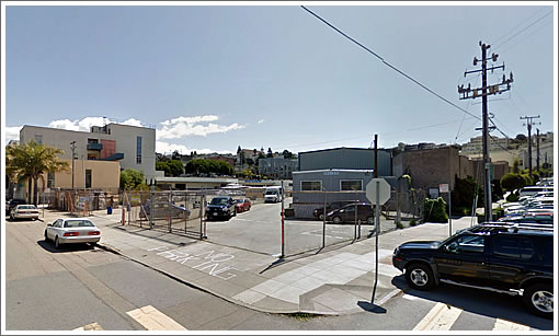
Related California, the Irvine based developer of The Paramount in San Francisco, has quietly filed a proposal to demolish the three one-story industrial buildings at 1601 Mariposa Street with plans to construct two buildings with 291 dwelling units over 5,300 square feet of commercial space and parking for 235 cars on the site across from Jackson Playground (and Anchor Brewing Company) at the base of Potrero Hill.
While we haven’t yet seen the design, the site is zoned for 40 feet and the development includes a mid-block pedestrian mews, connecting 18th and Mariposa Streets. And with 291 proposed units, which were not counted in Planning’s last report, the housing pipeline for the Potrero Hill/Showplace Square area is now over 3,000 units.
Looks good, though maybe the folks who wanted to develop the warehouse next door should coordinate with these developers. Given the slope of the hill on Arkansas, it might make sense to develop that part while they can still get access through the above site.
The developer should make a deal with Anchor to run a chilled line directly from their finishing tanks to metered taps in the new apartments.
@Adam – The PPA refers to lots 4005/001B AND 4006/006 and also mentions frontages on all four blockfaces.
Good news. That lot is ugly as is and totally out of place. I do think the Planning Dept. is going to require a reduction in hight, at least along 18th St. And of course they will not allow .80 parking spaces per unit. Potrero Hill is one of the few parts of the city where street parking is still bearable and it is official socialist policy that parking must be a pain in the arse everywhere.
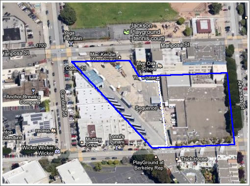
The lot is part of the old Western Pacific right of way.That accounts for its diagonal shape. Just south of there was a tunnel that began near 18th and Arkansas and emerged near 20th and Missouri. It burned in the 1960s, and some of the houses over the tunnel subsided.
Patrick: I believe that was the Southern Pacific right of way. The Western Pacific railroad terminated at Oakland (and San Jose) and never went to San Francisco, if memory serves right.
Pretty much all of the diagonal lots in the Mission are former RR right of ways.
http://www.davidrumsey.com/luna/servlet/detail/RUMSEY~8~1~214476~5501692:San-Francisco-And-Vicinity-Issued-B
This map shows the SP RR path as it curved through the Mission. You can also check out David Rumsey’s 1936/7 aerial of San Francisco and see how the railroad actually looked.
Interesting tid bit: Many of the lots are still owned by Southern Pacific. I have found small little corner lots (10sqft) that are in SP’s name.
Parking isn’t that great in the area. I used to work a block from there and every day all the streets nearby were 100% full.
good parking ratio: almost 1:1 again. The additional car store spots should reduce local congestion that could occur from new units
I’m ok with the parking ratio proposed here. and remember, this is the developer asking for less than 1:1 parking here (it’s in an area that requires 1:1 per current code).
Serge, actually, the tunnel belonged to Western Pacific Railroad, which had a small rail network in San Francisco that served the industrial district. It connected with the rest of the line via a rail ferry. The ferry terminal was located at the foot of Army Street (Cesar Chavez Street).
http://www.coopersvilleandmarne.org/Story-MemoriesRailsinSanFrancisco.html
http://www.youtube.com/watch?v=8aqxoPCJpBA
http://www.xconomy.com/national/2012/08/17/the-case-of-the-tilted-clubhouse-a-geographical-detective-story/attachment/potrero-hill-tunnel/
Odd, how does this make sense without the property at the corner of 18/Arkansas? How much are developers going to get out of this if building up the bus parking lot at a weird angle in the middle of the block?