The goal of San Francisco’s “Green Connections” project is to improve non-motorized access to parks, open space and the waterfront in San Francisco by re-envisioning target City streets and paths as ‘green connectors,’ “building on current efforts to create sustainable corridors that enhance mobility, green neighborhood streets, and improve pedestrian and bicycle access to community amenities and recreational opportunities.”
The connector streets “provide opportunities for greening and landscaping; enhancing wildlife habitat; managing stormwater; and calming traffic. They will be designed to encourage and support active transportation, to enhance urban ecology and promote stewardship and placemaking, making it easier and safer to connect to parks.”
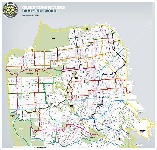
Tomorrow, San Francisco’s Planning Department will unveil a draft map of over 140 miles of potential ‘green connectors’ throughout the city, a network of 25 routes identified by a geographic start and end point, and a target species associated with the route:
1. Presidio to Bay: Monarch
2. China Beach to Bay: Pygmy Nuthatch
3. Market to Beach: Anna’s Hummingbird
4. Bay to Beach: Cedar Waxwing
5. Sunset to Hills: Green Hairstreak
6. Mission to Peaks: Anise Swallowtail
7. Precita Creek to Beach: California Buckeye
8. Islais Creek: Holly-leaf Cherry
9. Yosemite Creek: Red-winged Blackbird
10. Ingleside: Coast Live Oak
11. Lake Merced to Candlestick: Cliff Swallow
12. Lincoln Park to Zoo: Pacific Dunegrass
13. Presidio to Park Merced: Coast Buckwheat
14. West of Twin Peaks: White-crowned Sparrow
15. Marina Green to Dolores Park: West Coast Painted Lady
16. Excelsior: Western Fence Lizard
17. Tenderloin to Potrero: Western Tiger Swallowtail
18. Wharf to Yerba Buena: Wild Bees
19. Downtown to Mission Bay: Western Gull
20. Folsom Street: Red Admiral
21. Mission Creek to McLaren: Blue Elderberry
22. Bayview to Bay Trail: Black-tailed Jackrabbit
23. Ridge Trail: California Quail
24. Crosstown Trail: Coyote
25. Shoreline: Western Snowy Plover and Salt Marsh Harvest Mouse
The network will likely take at least twenty years to be built out, with the first six connectors (Bayview-Hunters Point, Chinatown, Potrero Hill, Tenderloin, Visitacion Valley, and Western Addition) slated to be designed over the next year.
While plugged-in people get a sneak peak today, the official unveiling will take place tomorrow, October 3, from 5:30 to 7:30 pm in the LGBT Community Center’s Rainbow Room at 1800 Market Street.
∙ Green Connections: Project Overview & Context | DRAFT Network Map
I hope it does not cost too much. I would rather pay medical insurance and pension to the employees rather than another nice project but not one that is ” absolutely” necessary.
I went to the website and opened and reviewed several of the pdf documents there. I still have no idea what a “green connection” actually is. Are they just closing off these streets to car traffic? Are they pulling up pavement and planting grass? Are they repurposing roads as bike and walking lanes? Entirely unclear from anything I could find.
This is the kind of project that makes SF look loonie. In implementation it might result in some nice streetscapes that are, in fact, greener. But the idea of creating corridors based around a specific species is pretty lunatic. I’m sorry, but the Coyotes are not going to recognize that a corridor has been created for them.
@curmudgeon: I’m glad to see that Planning Staff were thoughtful (and skilled) enough to make sure that the Coyotes and the Jackrabbits ne’re shall meet (could get ugly at coyote lunchtime …)
🙂
I’m always in favor of building a better network to help people get around on their own steam. And honoring our local species is grand. But put the two together and it just comes off as pretentious drivel. “I’m going to skate the Western Fence Lizard this morning.” What ? I’m so glad not to have been involved in what must have been the heated discussions required to narrow down the list of 25 species.
The city already has a great numbered bike route system. Why confuse people further by overlaying more network with a different (and quite verbose) naming? Just assign new numbers and subtitle the routes with the species. Speaking of overlaying, I hope someone overlaid this new network on the existing network to ensure that the two work well together.
The “U” shaped routes like 5 and 6 should be reconfigured so they’re useful for transportation as well as recreation. For example you could just take one of each leg from 5 and 6, connect them at the middle of the city, and create two east-west routes.
shza – The docs don’t get into too much detail on what would actually be constructed but we can expect that there would at least be a signage budget a la the existing network and the 49 mile drive. The docs allude to traffic calming which tends to be pretty inexpensive. Then there’s this: “Increase permeability of the ground surface to reduce storm water runoff”. What? What the heck does this have to do with creating recreational/transport routes? Looks like one of the stakeholders on this project got their pork poked in.
A quick glance at the network map shows that the routes tend to zigzag through lower traffic streets that are already more pleasant to walk, skate, ride, etc. Signage will help people find and follow those nicer but complex routes. Seems like a project that can improve the city at low cost.
No more filling stations, fewer cars, looks like the city is moving in directions that themselves will be sustainable. I live in the inner Sunset. You should see the life threats that those on two-wheelers take… all against the law. Talk about driving defensively!!!
Ahem… do any of you think that 7th avenue is not a busy street? (7th is a major route to USCF).
I really hope that they aim high and tear up the pavement and turn some roads into parks and trails. that would rock.
“Calming” traffic is such a disingenuous term. It usually means making driving ever more difficult which, far from calming drivers, infuriates them.
If they pull up the pavement on the bike routes so the grasshoppers can thrive, I’ll be thrilled.
I got rats running along my back fence. Does that count?
How is it that this is what concerns city planners and not the REAL problems of the city.
We are now known worldwide for our homeless problem and now for our filthy streets as well. And then there is MUNI! We have the oldest fleet of trains and bus vehicles in the country. (according to SaveMuni) Let’s fix the problems first and then we can worry about the coyotes and crickets.
Whatever this is supposed to be, do it conjunction with the Bike Coalition. The inevitable removal of select streets throughout the city should be done with the planning and necessary funding for the growing bike infrastructure in the works. Would seem that these two efforts go hand in hand.
I agree with shza– what the hell are these people planning? I have no idea what all this means: more bike lanes? Route markers, like the 49 mile drive? Are these streets to be closed, dug up, converted to grassy walkways? You can’t tell from their website.
I give this organization an F for its failure to communicate what they are up to. It’s obvious they spent a good deal of their funding on their nice graphics, which are full of vague platitudes and pretty pictures while providing no specifics about their scheme. I suspect they actually know what they want to do, but they seem afraid to tell us.
I am impressed though that they could be convincing enough to get funding for this boondoggle.
Muddle-headed projects like this should be killed quickly before they suck up the attention and money that should be spent on things we really need: decent public transportation, better schools, real help for the homeless, just for starters.
Just guessing steve, but I think that the project will lean more towards route markers and far away from tearing up streets. Most of the route segments are already pretty mellow so route markers are all that are needed to make them more useable. I agree though that the org putting this together needs to be a lot more specific on what they intend to do.
“Whatever this is supposed to be, do it conjunction with the Bike Coalition”
Why!? Why should the smallest slice get the most input? I would rather see Muni advocates have a say than the silly “Bike Coalition”. As a reminder, preiously on this site, as well as others such as the District 5 blog, it has been shown that bike ridership has not increased that much in the last 10 years. Muni ridership and auto traffic has however.
As also posted previously, the Masonic bike path was for approx. 20 bikes per hour during peak usage! Compare that to auto and MUNI ridership! So we take a lane of traffic away and are going to build a bike path?
The bike coalition shows that the loudest complainers get all the attention, while the vast majority of the city using Muni, walking, or using autos get punished instead.
I’d love to never hear the word “sustainable” again
Zig, thanks for the reminder.
I believe the Library of Congress will be banning ‘sustainable’ and ‘artisinal’ this year (neither, none too soon). 2013’s list already has anything with ‘crowd sourcing”, but the crowd-everything term will be percolating for another year.
Words lose their meaning, float around mindlessly and mellowly, and then get hijacked by marketing types or worse, politicians. We read Orwell’s essay on politics and words when we need a reminder of use of language for political (or corporate) gain.
@AntiCriticalMass — you miss the key reason why bikes are getting so much attention — growth potential — yes, biking is currently a small segment of the population, but as our city gets denser and more heavily populated, you can fit many more bikes into the same space that one car consumes. Thus, for the city to be functional in 20-30 years, it *has* to shift people out of their cars and into bikes and public transit. Anyone who is a forward looking leader gets this — that we cannot allow car use to grow with population growth — there is nowhere to add more cars to the streets — so we have to start now with a major shift to how we use our public spaces. Its true, some people will always need to drive (hand-caped and some elderly), but as the streets become safer and better designed for human use (i.e. less friendly to cars), more people will bike, walk, and use muni.
and yes, Muni really needs to be fixed too. The $$ going into improved bike infrastructure is *tiny* compared to what the city spends on muni, so its not like its an either/or question.
And, while muni is nice, I can generally get anywhere I want in the city faster by bike than by muni, so i see biking as a better choice.
^^^ What Bike4TheFuture said ^^^
SF is welcoming more people but has a limited footprint. The only way we can accomodate this is by increasing density but this means more people to move around. We can add a few more cars, but not that many. The next best thing is having more public transit, but that’s costly and slow to roll out. The fastest bangs for the bucks is having many of the new people embrace cycling.
Also, many of the new SF denizens are young. They can cycle, especially if they live/work here.
I also go faster than Muni (surface Muni, that is). One big upside is that cycling brings me from doorstep to doorstep. Muni doesn’t. Driving seldom offers you that option too.
A warning to all drivers out there who were planning to come this WE for Fleet Week: The northbound lane of the Embarcadero will be closed from Washington up, reserved to bicycles and emergency traffic.
But I am sure 1000s of drivers will still flock in and get stuck as usual while the show goes on. The fun never stops.
Find out more at the Green Connections meeting tonight at 5:30 PM at the LGBT Center, 1800 Market Street.
It seems most poster don’t know what it is. From my understanding, it is a trail map across San Francisco. It is like the San Francisco Bay Trail. It start off as a vision and in many parts unbuilt trail. Over the years people work to built it out and may in another generation it will be fully built out.
The first step of the green connection is this map and some I’ve already seen some big green signage posted on the street. Eventually this will serve as a vision to built out the network and trails.
San Francisco is a wonderful place to walk. I think this is a visionary project.
Did anyone go to the meeting? Any more info on how this project will be implemented?
Meanwhile, the real green space, backyards, are routinely reduced to tiny concrete covered patios or parklets.
The Audubon society and NOAH has noted that the reduction in large urban green spaces – notably the center of city blocks – that had nesting trees and leafy plants has decreased the number of birds by removing their nesting areas and destroying migration markers. Without migratory and local predatory birds, scavenger species (species that do not rely on insects for food, like pigeons and crows) move in. Rodents increase because neither pigeons nor crows attack rats because these birds don’t nest in trees.
Green doesn’t mean genuine greenery anymore, it’s a buzz word.
UPDATE: The Final Map For 115 Miles Of Green Connections To Crisscross SF.